Project Schedule Design Schedule: Field Field Office Construction - - PowerPoint PPT Presentation

project schedule
SMART_READER_LITE
LIVE PREVIEW

Project Schedule Design Schedule: Field Field Office Construction - - PowerPoint PPT Presentation

Project Schedule Design Schedule: Field Field Office Construction Concept of Advertise Inspection Review (Final Complete Operations Review Engineering) July 2014 July 1, 2015 August/ (Preliminary April/May 2014


slide-1
SLIDE 1

Project Schedule

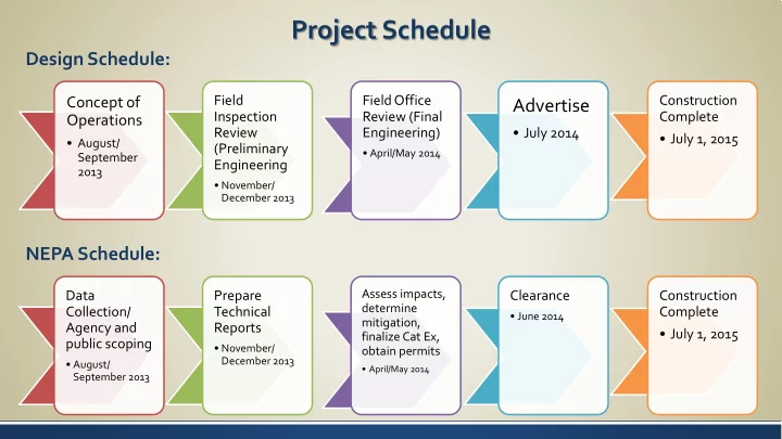
Concept of Operations

  • August/

September 2013

Field Inspection Review (Preliminary Engineering

  • November/

December 2013

Field Office Review (Final Engineering)

  • April/May 2014

Advertise

  • July 2014

Construction Complete

  • July 1, 2015

Data Collection/ Agency and public scoping

  • August/

September 2013

Prepare Technical Reports

  • November/

December 2013

Assess impacts, determine mitigation, finalize Cat Ex,

  • btain permits
  • April/May 2014

Clearance

  • June 2014

Construction Complete

  • July 1, 2015

Design Schedule: NEPA Schedule:

slide-2
SLIDE 2

Draft Purpose and Need

Based on six recent studies:

  • Efficient Use of Highway Capacity, November 2010
  • I-70 Reversible Lane Phase 1 Feasibility Study, August 2010
  • I-70 Hard Shoulder Running Report, July 2011
  • I-70 Mountain Corridor Mobility and Operational Assessment,

August 2011

  • I-70 Reversible Lane Phase II Feasibility Study, March 2012
  • I-70 Peak Period Shoulder Lane Feasibility Study, March 2013
slide-3
SLIDE 3

Draft Purpose

The purpose of the PPSL project is to:

  • Provide short-term eastbound operational

improvements.

  • Relieve traffic congestion during peak periods.
  • Be implemented within a short time frame.
  • Avoid substantial construction outside of the

existing I-70 highway footprint.

  • Be implemented in advance of longer-term

major improvements to the I-70 Mountain Corridor.

slide-4
SLIDE 4

Draft Need Statement

TRAVEL TIME RELIABILITY

  • Severely compromised
  • Affects tourism
  • Affects economic development
  • Affects transportation-dependent

commerce

slide-5
SLIDE 5

Draft Purpose and Need

MOTORISTS DIVERT TO ALTERNATE ROUTES

  • Causes congestion on the frontage road.
  • Causes reduced safety on the frontage

road.

  • Frontage road provides access to numerous

adjacent properties and has a lower speed.

  • Frontage road is not suitable as an alternate

route for I-70 traffic.

slide-6
SLIDE 6

Draft Need Statement

CONGESTION-RELATED CRASHES

  • Far more crashes occur in the eastbound

direction than in the westbound direction.

  • For rear-end crashes, 69% of total crashes

for eastbound and westbound occurred in the eastbound direction.

  • For sideswipe crashes, 70% of total crashes

for eastbound and westbound occurred in the eastbound direction.

slide-7
SLIDE 7

Draft Need Statement

  • Emergency vehicles have no other way

to get to an incident on I-70 than to try to maneuver around traffic that is stopped because of congestion.

  • The resulting delay in effective

incident management compromises safety, substantially inconveniences

  • ther travelers, and results in economic

and environmental impacts.

EMERGENCY SERVICE PROVIDERS ARE DELAYED AND COMPROMISED.

slide-8
SLIDE 8

Break

slide-9
SLIDE 9

ENVIRONMENTAL ISSUES For Analysis and Documentation

BRIEF indicates that the resource is not present or is present but will not be impacted. SOME indicates that the resource is present and may be impacted; further investigation and coordination will be required. FULL indicates that the resource will be impacted and may require mitigation; further investigation and coordination will be required.

slide-10
SLIDE 10

Full Assessment

FULL indicates that the resource will be impacted and may require mitigation; further investigation and coordination will be required.

Public Involvement

  • Will utilize the I-70

Mountain Corridor CSS process plus additional public involvement as appropriate Storm/Water Quality

  • Will do a full analysis

including development of measures consistent with the Clear Creek County SCAP and involvement of the SWEEP committee. Transportation

  • Will evaluate VMT

and VHT changes, changes in travel time and congestion, effects to safety and any mitigation needed to assure planned operation is safe. Visual/Aesthetics

  • Will be focused on

visual impacts of additional signage for the PPSL. Wetlands and other Waters of the US

  • Will conduct wetland

delineations in areas that may be physically impacted. Will analyze practicable alternatives to minimize or avoid

  • impact. Will

coordinate with the SWEEP Issues Task Force and the USACE.

slide-11
SLIDE 11

Some Assessment

SOME indicates that the resource is present and may be impacted; further investigation and coordination will be required.

Air Quality

  • Will evaluate changes in VMT and
  • VHT. Will conduct climate change

analysis plus mobile source air toxics analysis. Area is not in a non-attainment or maintenance area so no CO hot spot analysis is

  • needed. Will need to determine if

a conformity analysis is needed since the period of operation is so minimal. Environmental Justice

  • Will assess Census data to

determine the low income and minority populations. If the PPSL is tolled, the accessibility of this to low income and minority populations will be analyzed. Since the physical improvements are so minimal and there will be mobility benefits during peak hours, it is unlikely there will be disproportionately high and adverse effects to low income and minority populations. Floodplains

  • Likely minimal impacts except at

bridge replacement locations or retaining wall locations. Will involve SWEEP Issues Task Forces in discussions of analysis findings.

slide-12
SLIDE 12

Some Assessment

SOME indicates that the resource is present and may be impacted; further investigation and coordination will be required.

Hazardous/Solid Wastes

  • Will conduct testing to

determine presence of any hazardous or solid waste into historic mine waste. Since physical impacts are minimal, it is likely the anticipated level

  • f concern is low.

Noise

  • Will take existing noise

measurements and anticipate a NEPA level analysis looking at locations where travel lanes may move closer to residential

  • r other sensitive receptors.

CDOT has already determined the project is not a Type 1 project so no analysis is needed in compliance with the 2011 guidance. Recreation

  • Will evaluate impacts to rafting

and fishing, USFS access

  • points. Since physical impacts

will be so minimal, level of concern is low.

slide-13
SLIDE 13

Some Assessment

SOME indicates that the resource is present and may be impacted; further investigation and coordination will be required.

Section 4(f)

  • Will determine what

recreational Section 4(f) properties there are based

  • n ownership, public access

and inclusion in an adopted

  • plan. Will coordinate with

Section 106 task to incorporate any historic

  • properties. Will analyze for

de minimis impact. Since no new ROW is needed, anticipate something less that a full Section 4(f) evaluation. Socioeconomics

  • Will analyze effects to safety

and emergency services, economic effects of lessening of congestion during eastbound peak period, improvements in mobility. Wildlife/Fisheries

  • Will coordinate with CPW,

but anticipate minimal impacts because the physical impacts are so minimal. Will coordinate with ALIVE Issues Task Force. Threatened and Endangered Species (T&E)

  • Anticipate no T&E species

are impacted—except for South Platte River species.

slide-14
SLIDE 14

Brief Assessment

BRIEF indicates that the resource is not present

  • r is present but will not be impacted.

Paleontology

  • Similar to

the Twin Tunnels EA Right-of-Way

  • Minimal to

no additional right-of-way is anticipated to be needed. Section 6(f)

  • Will

coordinate with Clear Creek County, but anticipate no resources. Vegetation

  • Since

minimal physical impacts will

  • ccur.