PORT OF SAN FRANCISCO WATERFRONT LAND USE PLAN Prop H (1990) - - PowerPoint PPT Presentation
PORT OF SAN FRANCISCO WATERFRONT LAND USE PLAN Prop H (1990) required a Waterfront Land Use Plan Port property in BCDC jurisdiction Define Acceptable Uses Hotels prohibited on piers Prioritize Maritime Industry
WATERFRONT LAND USE PLAN
- Port Commission includes all Port property in planning process
- Waterfront Plan Advisory Board recommended draft plan in 1995
- Waterfront Design & Access Element added per Port Commission
- Port Commission approved Waterfront Plan in 1997
- Port, City, BCDC plan amendments, 1998-2000
- Prop H (1990) required a
“Waterfront Land Use Plan”
- Port property in BCDC jurisdiction
- Define “Acceptable Uses”
- Hotels prohibited on piers
- Prioritize Maritime Industry
REUNITE THE CITY WITH ITS WATERFRONT
- A Working Port
- A Revitalized Waterfront
- A Diversity of Activities and Opportunities
- An Interconnected Network of Public Parks, Walkways,
Open Spaces and Transportation Improvements
- Urban Design Embracing San Francisco’s Past, Present
and Future, Worthy of the Waterfront Setting
First Priority: MARITIME USES
ACCEPTABLE USES
Long-term Development & Investment
Interim Lease Policies to Maintain Port Revenues
- Maritime and Real Estate lease revenues support capital
improvements and Port maintenance
- Over 500 leases for Port large, small, local businesses
- Light industrial and other uses, consistent with City
zoning, until long-term development
- Most leases are 10 years or less
- Up to 30 year interim leases in S. Waterfront to improve
industrial lands
WATERFRONT DESIGN & ACCESS ELEMENT
Port and Planning Department + Urban Design TAC Design, Preservation, City, Port, BCDC professionals
- Public Access & Open Space Network
- Public Views
- Port Maritime Historic Resource Preservation
- City Pattern & Urban Design
- Architectural Design Criteria
- City Review: Waterfront Design Advisory Committee
WATERFRONT PARKS, PUBLIC SPACES, WALKABILITY
- Inter-connected network of parks, plazas, public access, and habitat
- Embarcadero spine to the north / Blue Greenway spine to the south
- Many recreational uses on land and from the water
- Compatible with maritime industry
- Promotes environmental stewardship and appreciation of SF Bay
SEQUENCE AND VARIETY
- Many types of public
- pen space experiences
- Inter-connected within a
5-10 minute walk
- Highlights diverse Port
maritime industries
WATERFRONT DEVELOPMENT OPPORTUNITY AREAS
An open space network + Variety of maritime uses + Development locations + Neighborhood character = Urban waterfront, knit into City fabric
EMBARCADERO HISTORIC DISTRICT
- Pier 45 (Fisherman’s Wharf)
to Pier 48 (Mission Rock)
- Finger piers, bulkhead
wharves, and the Seawall
- Highest preservation
standards
Pier 70 UNION IRON WORKS HISTORIC DISTRICT
- 54 historic resources
from 1885-1945
- Ship building, steel mills,
industrial innovation
- Ship repair continues today
5 WATERFRONT PLAN SUBAREAS
DEVELOPMENT PROJECT REVIEW PROCESS
PORT ADVISORY COMMITTEES
What’s happened under the Waterfront Land Use Plan?
- Assessed accomplishments, changes & needs, 1997-2015
- Fall 2014- Spring 2015 public comments; Final report: June 2015
- Led to Waterfront Plan Update Policy Issues
- Details at www.sfport.com/wlup
$1.6 billion in public and private investment 63 acres of new waterfront open space
44 new acres planned of waterfront open space
19 historic resources rehabilitated 7 derelict piers and wharves removed from the Bay AT&T Ballpark constructed 2 new waterfront neighborhoods planned
WATERFRONT PLAN SUCCESSES
SEA LEVEL RISE
How should the Port manage and prepare for climate change and sea level rise?
SEISMIC SAFETY
How should the Port strengthen the 4-mile Embarcadero seawall and improve seismic safety?
ENVIRONMENT
How should the Port update policies for environmental protection and sustainability?
HISTORIC RESOURCES & PORT FACILITIES
How should the Port prioritize investments in repair, maintenance and replacement of Port facilities, including historic resources?
OPEN SPACE
How can we expand recreational open space activities? How do we improve the Embarcadero Promenade and public realm that complement transportation improvements?
MARITIME BERTHING
How do we balance the needs of maritime berthing and accommodate more public access on piers?
TRANSPORTATION
How can we prioritize transportation services and improvements?
DEVELOPMENT
How much is left to develop, what are the priorities for such development, and how can the review process be improved?
FINANCES
What are the Port’s existing and future revenue sources? How does the capital and budget process advance Waterfront Plan objectives?
Waterfront Plan Update POLICY ISSUES
www.sfport.com/wlup Waterfront Plan Update Project
November 17, 2015
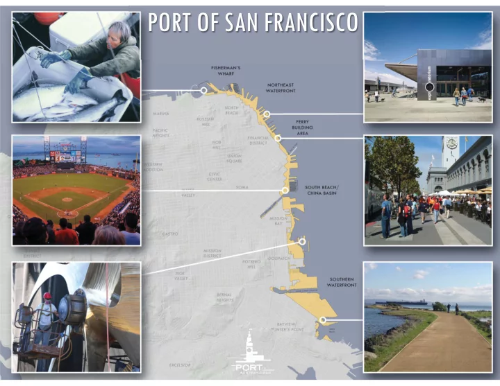
NEXT UNDERWAY ACCOMPLISHMENTS
Northeast & South Beach Subarea Planning
South Beach subarea planning Northeast Waterfront subarea planning