
SLIDE 1
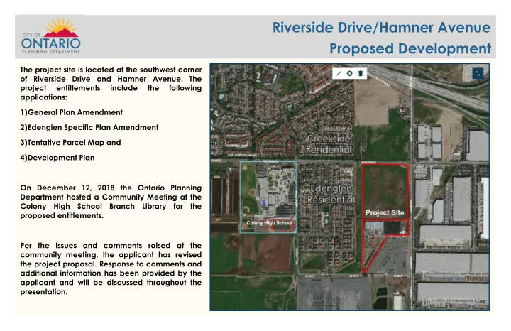
The project site is located at the southwest corner
- f Riverside Drive and Hamner Avenue. The
Riverside Drive/Hamner Avenue Proposed Development The project site - - PowerPoint PPT Presentation
Riverside Drive/Hamner Avenue Proposed Development The project site is located at the southwest corner of Riverside Drive and Hamner Avenue. The project entitlements include the following applications: 1) General Plan Amendment 2)
“Community members opposed the proposal to eliminate the commercial land use designations” The applicant's initial proposal was to change the General Plan land use designation from General Commercial and Business Park to Business Park and Industrial (maps displayed on the right).
In response to community comments the applicant performed an economic feasibility study and revised the proposed General Plan amendment to include (map highlighted in red on the far right):
4.13 acres of Community Commercial
located on the northeast corner of the project site.
3.51 acres of Business Park located on the
northwest corner of the site.
38.64 acres of Industrial located on the
southern portion of the site.
“Community members opposed the proposal to eliminate all commercial land use designations from the Edenglen Specific Plan” The applicant's initial proposal was to amend the Edenglen Specific Plan and change the land use designation from Community Commercial, Commercial/Business Park Flex Zone to Business Park and General Industrial. In response to community comments the applicant has revised the proposed amendment to include:
4.13
acres
Neighborhood Commercial located
the northeast corner of the project site.
3.51 acres of Business Park located
38.64
acres
Light Industrial located on the southern portion of the site.
The site plan on the immediate right was presented at first community meeting. In response to community concerns regarding the elimination of commercial land uses the site plan was revised (displayed on the far right of the screen). Building 1 was eliminated from the project site plan and has been reserved for a future commercial development. The 4.31 acres of commercial land can accommodate approximately 40,000 square feet of future commercial uses. No proposal for the commercial corner has been submitted to date. Building 2 is located within the proposed Business Park land use designation that allows for commercial and indoor recreational uses along with business park uses. Buildings 3, 4, 5 and 6 are within the Light Industrial land use designation which allows warehouse, light manufacturing and similar types of uses.
Development Plan Proposal from First Community Meeting New Revised Development Plan Proposal
Building 4—West Facing Building Elevation Building 3—West Facing Building Elevation Building 6—West Facing Building Elevation Building 2—West Facing Building Elevation
“Community members expressed concerns with the west building elevations and the need to create an attractive view for the adjacent residential community ” In response to community comments the buildings have been designed to have an office-like appearance and the western building elevations have been enhanced to provide an attractive view from the adjacent residential.
In response to community comments a combination of Southern Live Oak trees and Western Redbud trees will be planted along the western property lines within a landscape planter that varies in size from 6 to 23 feet wide. Additional landscape planters are provided directly adjacent to each building that range in size from 6 to 12 feet wide. Large plants will be used along the western property line in conjunction with screen walls to mitigate noise travel and create a more visually appealing view from the residential community .
“Community members requested a landscape buffer along the western elevation to buffer noise, light and soften views of the west facing buildings”
Southern Live Oak Western Redbud Western View of Proposed Project looking southeast
Cross-Section looking south from Riverside Area between Proposed Project and adjacent Residential
Building 3—North Facing Building Elevation Building 2—North Facing Building Elevation North facing view of the Project Site looking south towards Building 2, 3 and future commercial site Walkway provided in front of Building 2
Building 3—East Facing Building Elevation Northwest Corner view of the Project Site looking southeast Building 4—East Facing Building Elevation Building 5—East Facing Building Elevation
In response to community comments/concerns the project has been designed to minimize noise impacts to the residents. The truck yards have all been oriented away from the western property line. Screen walls that are 12-feet high have been included around the truck courts and have been strategically located along the western property line to block noise traveling off the
along with the 200-foot SCE utility corridor that separates the properties will substantially diminish any noise impacts to the adjacent residential community. A noise study was completed by Urban Crossroads (April 2020) that analyzed operational noise impact increases along the eastern property line of the Edenglen residential community. Urban Crossroads measured existing noise levels on October 10, 2019 and modeled the increased noise that will be generated by the proposed operations at the property. The study concluded that the operation of a typical warehouse distribution center would result in a noise increase of 0.3 dBA, which is generally indiscernible to the human ear. Furthermore, the placement of the buildings will assist in the reduction of traffic noise that currently exist from Hamner Avenue and help reduce wind and dust impacts from seasonal Santa Ana winds.
“Community members had concerns with potential noise impacts from the proposed industrial use and project ”
Riverside Drive Hamner Avenue Screen Walls
Proposed Screen Wall
“Community Members had concerns about Graffiti”
In response to community concerns, graffiti prone surfaces in highly visible areas, such as screen walls facing public streets were minimized and will be treated with a graffiti-proof coating . Wrought iron fencing is used where mitigation of noise and visual impacts are not a concern. Any graffiti that does occur on the property will be cleaned per City requirements within 72 hours of receiving notice.
“Community members had concerns about light Impacts from the Project”
Outdoor lighting will be shielded and oriented inward towards the project to minimize light pollution off-site. Dense landscaping and screen walls along the western edge of the property will further shield residents from any light pollution at night.
In response to community concerns the project has been designed to have truck traffic enter and exit primarily
Hamner Avenue. Hamner Avenue is a designated Truck Route and truck traffic will primarily be coming onto the project site from the nearby SR 60 Freeway I- 15 Freeway interchanges. Building 2 and future commercial development will have primary access from Riverside Drive. Buildings 3, 4, 5 and 6 will have primary access from Hamner Avenue. “Community members had concerns that the proposed plan would increase truck traffic on Riverside Drive ” The street frontages along Riverside Drive and Hamner Avenue will be improved (curb, gutter and sidewalk) and no parking will be allowed. The development of the project site will create more eyes on the street and discourage illegal uses such as street racing. In response to community concerns on-site security patrol will be provided for the property. On-site security will help prevent any undesirable use of the property at night or weekends and can alert law enforcement of any illegal activity occurring off-site and within the immediate area. “Community members had concerns with street parking of trucks along Hamner Avenue and undesirable uses of the public streets (such as street racing)”
Traffic is currently problematic on Riverside Drive and Hamner Avenue since the existing streets are not properly sized for the amount of vehicle traffic in the area. In response to community comments, the project will widen and construct new street improvements on Riverside Drive and Hamner Avenue and widen the intersection to improve the flow of traffic. These improvements will mitigate the traffic impacts that may be associated from the proposed project, and improve vehicular traffic flows along Riverside Drive and Hamner Avenue. These improvements include: Widening of Riverside Drive and H a m n e r A v e n u e t o accommodate more lanes (3 lanes in both directions), a new median
each street, neighborhood landscaped edge, new sidewalks (5 feet wide) and parkway landscaping (7 feet wide) along both street frontages. Widening the Riverside Drive a n d H a m n e r A v e n u e intersection to increase traffic flow and installation of new traffic signals. Installation of new traffic signals
Avenue at the driveway entrances to the project site.
“Community members voiced concerns about the project causing damage to Roads and Infrastructure”
Street widening, curb & gutter Street widening, curb, gutter, parkway & sidewalk Future traffic signal
Riverside Drive
Hamner Avenue Street Section
Hamner Avenue
Riverside Drive Street Section