
SLIDE 1
Pima ma Co Coun unty y Mu Multiple-Spe pecies Co Cons - - PDF document
Pima ma Co Coun unty y Mu Multiple-Spe pecies Co Cons nserva vation P n Plan an Pima County Office of Sustainability and Conservation Chapt apter er 1 1: Purpo pose a e and d Need ed Photo by Aaron Flesch What hat doe
Photo by Aaron Flesch
View from Diamond Bell Ranch, Brian Powell 2010
Year
1 2 3 4 5
Cost in Millions $
1 2 3 4 5 Existing Costs New Costs
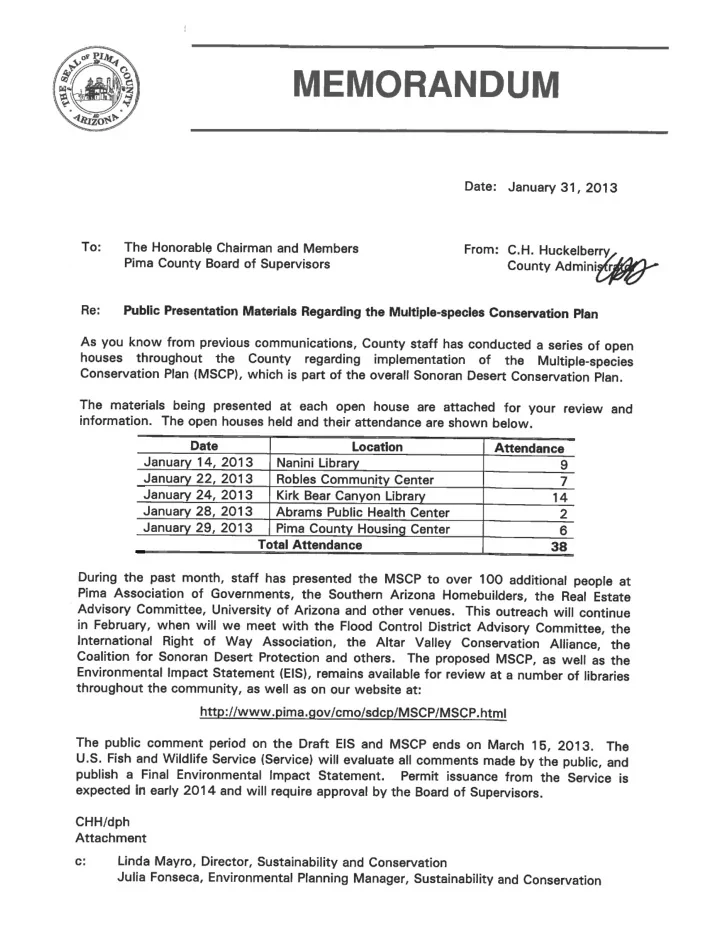
Multi-species Conservation Plan (MSCP), which, if approved by the U.S. Fish and Wildlife Service, will streamline public-sector and private-sector development compliance with the Endangered Species Act while protecting endangered species and their habitats. In the coming months, the public will have a chance to comment
process before it goes to the County Board of Supervisors for fjnal adoption.Tiis report reviews the history of the MSCP , its relationship with the award-winning Sonoran Desert Conservation Plan, what benefjts the MSCP will bring to the community, and what obligations the County, developers, and the taxpayers will have over time. Tie report also highlights other benefjts of conservation actions undertaken by Pima County, including economic, recreation, and health benefjts.
Sands Ranch in the foreground and the Mustang Mountains in the background. Sands Ranch contains some of the best grassland habitat in Pima County’s land holdings. This agave-studded ranch also provides important habitat for the endangered lesser long-nosed bat.
Tie Sonoran Desert Conservation Plan: A Blueprint for Urban Growth and Conservation
Pima County has a history of grappling with contentious land-use decisions, starting as early as the 1970s. Since that time, many residents have been concerned about rezoning decisions in exurban, natural areas where proposed developments have threatened to alter the natural environ- ment and cultural character. Concerns about the destruction of natural and cultural features to make way for housing, shopping centers, and roads often resulted in polarized hearings before the Board of Supervisors. Tiese land-use debates raged unabated through the late 1990s, when the cactus ferruginous pygmy-owl was listed as an endangered species under the Endangered Species Act. Tiat 1997 listing — and subsequent court battles — left the real estate market, individual developers, and the public sector uncertain about what was needed to comply with the listing and associated
bring compliance and certainty into balance. Tie situation with endangered species and development interests was not unique to Pima County; many other communities have similarly faced species’ listings under the Endangered Species Act. What made Pima County’s situation difgerent was the County used the listing decision as a catalyst to transform the conversation from a single-species conservation challenge into a regional vision for balancing economic development with the protection of our natural resources and cultural
known as the Sonoran Desert Conservation Plan (SDCP), has been to identify those areas where urban development is most desirable as well as those areas where conservation of rural landscapes and natural resources is preferred. In its implementation, this vision resulted in voter-approved bond funding to acquire open-space properties that conserve many species and their habitats, sustain ecosystem functions, protect cultural resources, and support the continuation of cattle ranching. Tiis vision continues today by way of current planning efgorts that are now more actively focusing
long-term sustainability of our community.
2
Pima County acquired the Raul M. Grijalva Canoa Ranch Conservation Park in 2001. Protection of lands like Canoa have become the hallmark of the SDCP. Photo by Chuck Park. The listing of the cactus ferruginous pygmy-owl as and endangered species marked the begin- ning of the community discussion that culmi- nated in the Sonoran Desert Conservation Plan (SDCP). Photo by Aaron Flesch.
Tie Endangered Species Act and Pima County
Tie ESA afgords certain legal protections to species listed as endan- gered or threatened. Under the ESA, it is illegal to knowingly “take” (kill, harm, or harass) a threatened or endangered species. However, Section 10 of the act provides for legal take of a listed species when: 1) the taking is incidental to an otherwise lawful activity (i.e., the intent
“Section 10”) permit is authorized, which details measures to avoid, minimize, and/or mitigate for that take. Tie cactus ferruginous pygmy-owl lost its endangered status in 2006, but the delisting did not eliminate the County’s need for a Section 10 permit. Tiis is because Pima County is located in one of the most biologically diverse regions in the U.S., and as a result, the number of listed species (16) is quite high relative to other areas of the U.S. In addition to those species that are currently listed, there are many more species found in Pima County that are being proposed or petitioned for ESA coverage. Tiis high number of currently or potentially listed species, coupled with continued development pressure on natural areas, Since 1998, when the SDCP was fjrst launched, it has received numerous awards as one of the nation’s most ambitious, locally driven conservation plans. Tiese accolades point to the SDCP’s incorporation of sound science and community values, which set the SDCP apart from most other plans of its type. Much of the early planning efgort for the SDCP was focused on conservation of natural resources. Considerable time and efgort was devoted to identifying those species that were most at risk by the expansion of residential and commercial development in unincorporated Pima County. Mapping the distribution of these species using geographic information system tools helped to determine if the County — through its land-use authority and land acquisitions — could contribute to the conservation of the species. Concurrent with the development of the scientifjc foundations of the plan were the workings of the SDCP Steering Committee, which was charged with a broad mission of representing community values and developing recommendations for Pima County on how to achieve compliance with the Endangered Species Act (ESA), particularly with regards to developing the MSCP . Tie Steering Committe was made up of self-chosen representatives from a broad swath of our commu- nity, including the real estate and mining industries, local ranchers, environmentalists, Native American tribes, and neighborhood groups.
3
The needle-spined pineapple cactus is an MSCP-covered species. It is possible that this species will be listed under the Endangered Species Act.
means that it will become increas- ingly diffjcult to avoid take of listed species. Given these circumstances, Pima County has continued to work with the community to develop the Multi-species Conservation Plan (MSCP) as the County’s ap- plication for a Section 10 permit. If approved by the U.S. Fish and Wildlife Service and adopted by the Pima County Board of Supervisors, the Section 10 permit will allow the County (and certain private development projects included under the permit) a specifjed level of take of listed spe- cies in exchange for implementation
to avoid, minimize, and compensate (mitigate) for that take.
4
Scope of the MSCP
Permit Area
Tie MSCP Permit Area (Figure 1) is the area within which the Section 10 permit will apply and is a subset of Pima County that includes: 1) Only those lands under the Pima County Board of Supervisor’s legal authority — principally private, unincorporated lands over which the Board has some regulatory authority — and those lands managed by Pima County for mitigation purposes; 2) all County-owned lands; 3) lands where Pima County constructs and maintains infrastructure on lands owned by another jurisdiction; 4) certain Arizona State Trust lands and Bureau of Land Management (BLM) lands that could be disposed to the private sector during the term of the permit; and 5) a subset of Arizona State Trust lands on which Pima County holds a grazing lease, including some lands outside of Pima County.
Aquatic habitats, such as this seasonal pool in the County’s Buehman Canyon property, provide important habitat for many rare species in Pima County.
5
Covered Species
Covered Species are those species that are (or could be) listed as threatened or endangered under the Endangered Species Act and that are likely to be negatively impacted by certain development activities within the Permit
based on more recent decisions about what activities to cover under the permit, as well as new information about the species themselves. Tie County is now proposing to cover 44 species (Table 1). Most of the species are not currently listed under the Endangered Species Act, but by including them within the scope of the Section 10 permit, Pima County will be assured that if any are listed as threatened or endangered during the 30-year term of the MSCP , no new conservation measures will be required of either the County or private development covered under the permit.
A l t a r W a s h B r a w l e y W a s h San t a C r u z R i ver P a n t a nMSCP PERMIT AREA - FEBRUARY 2011
Index Map Index Map Scale 1:250,000 1:2,500,000 The informato n d epi c te d o n th i s d i spl a y is th e re sul tPermit Area
Figure 1. Section 10 permit area. A subset of development activities that take place in the Permit Area will be covered under the County’s Section 10 Permit.
6
Taxon Common Name
Plants Pima pineapple cactus Needle-spined pineapple cactus Huachuca water umbel Tumamoc globeberry Mammals Mexican long-tongued bat Western red bat Southern yellow bat Lesser long-nosed bat California leaf-nosed bat Pale Townsend’s big-eared bat Merriam’s mouse Birds Burrowing owl Cactus ferruginous pygmy-owl Rufous-winged sparrow Swainson’s hawk Western yellow-billed cuckoo Southwestern willow fmycatcher Abert’s towhee Bell’s vireo Fishes Longfjn dace Desert sucker Sonora sucker Gila chub Gila topminnow Amphibians Chiricahua leopard frog Lowland leopard frog Reptiles Desert box turtle Desert tortoise (Sonoran population) Tucson shovel-nosed snake Northern Mexican gartersnake Giant spotted whiptail Ground snake (valley form) Invertebrates 12 species of talus snails
Table 1. Species that will be covered under Pima County’s MSCP. Species currently listed under the ESA are in bold. Pima pineapple cactus Gila chub Cactus ferruginous pygmy-owl Lesser long-nosed bat
7
Covered Activities
Private and County actions covered under the permit are called Covered Activities and are limited to grading and development of certain private land in unincorporated Pima County (see next paragraph) and County maintenance and construction activities, including capital improvement projects. Coverage for County activities also extends to some actions on ranchlands, including maintenance and construction of infrastructure, but not cattle grazing. Tie permit does not cover ground-disturbance activities by Federal agencies. Tie MSCP ofgers private property owners two avenues to gain the protection of the County’s permit.
for 14,000 square feet or more from Pima County. Grading activities will automatically be protected under the Section 10 permit whenever Pima County issues the grading permit, unless the property owner declines permit protection. Declining protection is known as “opting out.” If the owner does not opt out
cost to the property owner.
to a subdivision plat or development plan approved by Pima County. In these cases, the property owner must initiate the request for their development to be included under the County’s Section 10 permit and such action is at the discretion of the land owner. Tiis is the “opt in” method. Tie potential for such development to be included under the permit will be determined by eligibility criteria that include having an approved subdivision plat or development plan where the entire area is retained under a single owner- ship and where none of the development contem- plated by the plat or development plan has occurred. Tiere is a cost to the property owner when they choose to opt in. All fees are based on the fee-for- service principle. Everyone who opts-in will be required to pay an application fee and some may also be required to pay a compliance monitoring fee when natural open space set-asides within the development are dedicated as Section 10 mitigation lands. Tie County’s deliberations on the host activities that will be covered under the permit have resulted from
Many private-sector development activities, such as this residential construction, can impact endangered species. The Section 10 Permit will provide benefjts to some development projects, including certainty about compliance with endangered species regulations County development projects, including future construction and repair of bank stabilization along urban watercourses, will be covered under the Section 10 Permit. Photo by Regional Flood Control District.
8
numerous discussions with stakeholders and balanced with the County’s needs and obligation under the
Impact Statement (EIS), which is the U.S. Fish and Wildlife Service’s document that will accompany the County’s MSCP and be subject to public review. Alternatives range from only covering County activi- ties to covering all development activities for which the County issues a permit. Pima County believes that the suite of MSCP Covered Activities in the MSCP and the EIS’s preferred alternative is reasonable and prudent and that the mitigation needed to ofgset impacts from the Covered Activities is achievable.
Permit Timeframe and Expected Acres of Impact
Tie County is requesting a 30-year Section 10 permit to be divided into three 10-year phases. Tiis phasing strat- egy creates check points to monitor the plan’s implementation and efgectiveness. Prior to the end of the 30-year permit period, Pima County may decide to extend the permit or let it lapse. Regardless of whether the permit ex- pires after 30 years or is extended for an additional period of time, there will be some management and monitor- ing responsibilities that must continue indefjnitely. Pima County capped the amount of ground disturbance that will be covered under the permit at 36,000 acres, but the EIS will examine a range of alternatives that includes covering more or fewer acres. Tie map and description of the Permit Area (Figure 1; noted earlier) encompasses a much larger area than will ultimately be covered under the permit because exactly where private development activities will occur is unknown. However, County stafg developed a 30-year growth model to predict areas of
ty’s mitigation obligations under the permit.
Mitigation: Combining MSCP Needs with the SDCP Vision
Tie SDCP brought forward a landscape-level vision for conservation, and the MSCP will institutionalize many SDCP principles, especially with regard to long-term land conservation. Funded in large part by the 2004 Open Space bonds, the County now owns or leases over 200,000 acres that help the County meet key SDCP goals, but also provide the bulk of the land-based portfolio that Pima County will need in order to mitigate or compensate for the habitat loss caused by those public and private development activities that are covered under the Section 10 permit. Tie mitiga- tion approach that Pima County has put forward in the MSCP will require the County to have an aggressive and innovative conservation approach that seeks to match the scale of — and address the goals
.
The Pima pineapple cactus is an MSCP-covered species. The desert tortoise (Sonoran population) is not currently listed under the Endangered Species Act (ESA), but its declining numbers and increasing threats could result in the species listing.
During the development of the SDCP , the County convened a team of experts, known as the Science and Technical Advisory Team, which employed numerous sets of natural resource-related data to identify the relative importance of areas within Pima County (exclusive of the Tohono O’odham Nation) according to their value for conserving biodiversity. Tiis efgort resulted in the Maeveen Marie Behan Conservation Lands System (CLS; Fig- ure 2.), which is a map that incorporates key biological planning
prehensive Plan Update in 2001 and has since become a critical touchstone for many of the County’s planning endeavors and pro- cesses, including land-use decisions that come before the Board of
and quantitative natural open-space conservation goals for each
that in Biological Core Management Areas the guideline states that 80% of the area be retained as undisturbed natural open space; the goal for Important Riparian Areas is 95% natural open space; and the goal for Multiple Use Management Areas is 66 2/3% natural open space; etc.
9
Figure 2. The Maeveen Marie Behan Conservation Land System is a cornerstone of Pima County’s conservation activities, including the amount of land needed to ofgset development impacts are covered under the Section 10 Permit. The Bell’s vireo is an MSCP-covered species.
Tie CLS map is also integral to the County’s mitigation approach for the MSCP; it will be a primary tool in determining the acreage and quality of lands the County will need to provide as mitigation for Covered Activi-
are being impacted and the amount of that mitigation acreage must correspond to the percentage of natural
modeled future development onto the CLS map, Pima County estimates that approximately 116,000 acres will be needed to meet our Section 10 mitigation obligations. Tie lands that Pima County owns plus those the County currently holds under State grazing leases are a signifjcant down payment on this anticipated mitigation
and riparian forest to oak woodlands (Figure 4; next page). In addition to using bond-funded
tion lands, when a property owner desires protection under the Section 10 permit and exercises the opt-in method, Pima County intends to use natural open-space set-asides required by the Board of Supervisors during the rezoning process as mitigation (Figure 3). In this way, the MSCP honors the long-standing expectation that the private sector’s compliance with the CLS and SDCP would materially contribute to the County’s Section 10 permit. Additional legal protections will be placed on those natural open-space lands at the time they are designated as mitigation for Covered Activities. Tie purpose of these additional protections is to ensure that lands used for mitigation remain as permanent, undeveloped, natural open space. Ensuring the perpetual undeveloped, natural condition of these lands is required in order for the County to receive maximum mitigation credit for these lands.
10
Figure 3. Most land-use proposals that require a rezoning are required to provide natural open space set-asides to comply with the CLS. The natural open space set-asides shown here for the Santa Rita Mountain Ranch Specifjc Plan is an example of a CLS-compliant project whose open-space areas could be used as Section 10 mitigation land.
11
Figure 4. Since 2004, Pima County has acquired 13 active cattle ranches. Most ranches include both private land that is now owned by Pima County (shown in darker shades within most ranches on the map) as well as State and Federal lands, which the County leases (shown in lighter shades within most ranches on the map).
Land and Resource Management
Tie County is responsible for managment of County owned and leased mitigation lands to ensure that the natural and cultural resource values for which they were secured persists over time. How the County manages these lands for the benefjt of natural (especially biological) resources has a direct and critical relationship to the MSCP and, ultimately, the County’s receipt of the Section 10 permit. Current management efgorts focus on protecting important habitat communities like riparian areas, reducing the spread and adverse efgects of bufgel- grass and other invasive species, cleaning up illegal trash dump sites, and providing for recreational opportunities for people to enjoy resources without causing undesirable impacts. Because Pima County has acquired extensive lands with active livestock operations, management also focuses on maintaining the long-term health of these rangelands. Once Pima County has the Section 10 permit in hand, the current management activities will continue and will become a commitment under terms of the permit. Where natural open space set asides within a development are used as section 10 mitigation, management will remain the responsibility of the property owner. No additional, permit-specifjc requirements will be imposed on the private landowners or Home Owners Associations (HOA’s), but the landowner must comply with applicable County ordinances, adhere to any rezoning condi- tions that might have been applied by the Board of Supervisors if the property was previously rezoned, and conform with stipulations prescribed by the subdivision plat or development plan. In the execution of these responsibilities, specifjc attention will be placed
reasonable prevention of the spread of invasive species.
Permit Monitoring
As a recipient of a Section 10 permit, Pima County is obligated to provide the U.S. Fish and Wildlife Service with regular evaluations of how well it is doing in meeting the permit requirements. Tiis permit monitoring requirement has two components, compliance monitor- ing and ecological monitoring. Compliance monitoring demonstrates that Pima County has accurately accounted for take and subsequently provided the necessary amount of mitigation land. Ecological monitoring is more involved and requires the County to determine if implementation of the permit is having the desired environmental
being of individual species and their habitats throughout the 30-year permit period.
12
The lowland leopard frog is a Covered Species that will be monitored for the duration of the
the best lowland leopard frog habitat in southern Arizona. Monitoring the condition of resources, such as vegetation and ground cover, is a key aspect
the Section 10 Permit.
13
Pima County will also be assessing the efgects of climate as well as environmental threats such as invasive species because of the direct relationship these factors have in the long-term health of species’ populations and habitat
County will monitor the populations of 15 Covered Species, among them the Pima pineapple cactus, desert tortoise, two species of leopard frogs, and the cactus ferruginous pygmy-owl. Tie broad focus on species, habi- tats, and other environmental features follows the recommendation by the Science and Technical Advisory Team, which suggested that Pima County take a broader perspective and monitor a complement of ecosystem features (e.g., vegetation, water, climate, and land cover change) rather than focusing solely on tracking populations of individual species. Single-species monitoring is often the only focus of monitoring for Section 10 permits. As monitoring information is collected, the County expects to learn that some of its manage- ment activities have been successful while others may need to be adjusted. Tie intent is to make adjustments to on-going management activities with the expectation that these adjustments will have a favorable result on species and their
the responsibility of Pima County and any moni- toring that requires an on-the-ground presence will only take place on lands the County owns or lands on which the County holds a grazing lease. Annual Compliance Monitoring reports and Ecological Monitoring reports will be provided to the U.S. Fish and Wildlife Service. Tiese reports will also be available to any member of the public as well as the subject of regular updates to the Board of Supervisors.
A7 Ranch in the foreground with the Rincon Mountains in the background. A7 Ranch is the largest of the MSCP mitigation properties. Bufgelgrass is an invasive species that is prevalent throughout southern Arizona. It forms dense stands, which can lead to large and catastrophic wild fjres. Management and monitoring of this and other invasive species is an important priority for Pima County and for the MSCP.
Costs
Unlike most other communities with large-scale Section 10 permits, there are few commitments in the MSCP that would trigger new costs to the County (Figure 5.). Most of the elements proposed are already incorporated into — and funded as part
to the SDCP . Tie community’s investment in acquiring open space lands is a stellar example of getting a benefjt for dollars that have already been spent. As noted earlier in this report, the approximately 200,000 acres
bought and leased since 2004 will be used to fulfjll permit mitigation requirements. Approximately $139 million in bond funds was used to acquire these lands, which is a cost that the community has already sustained. To date, taxpayers have repaid a signifjcant amount of these bond funds. In fact, the aver- age contribution per property owner necessary to secure this portfolio of potential permit mitigation lands is only about $1.35 per month and as the County continues to pay ofg the outstanding balance, this amount will decline. Receipt of the Section 10 permit will carry some new costs, most of which will be related to those Ecological Monitoring tasks the County must perform under the permit in order to demonstrate that implementation of the MSCP is having an ecological benefjt. Current estimates indicate that the initial cost of this program will total approximately $570,000 annually for the fjrst few years and then level out at about $1.2 million annually as this monitoring program becomes fully implemented.
14
Year
1 2 3 4 5
Cost in Millions $
1 2 3 4 5
Existing Costs New Costs
MSCP/EIS Timeline and Public Review
Tie U.S. Fish and Wildlife Service is a federal agency subject to the requirements of the National Environmental Policy Act, which dictates a process by which the Service must evaluate the County’s Section 10 permit. Key considerations for the Service during the review period are the range of alternatives (one of which is the MSCP) and their potential to afgect the region’s human, natural, and cultural environment. At a time of their choosing, the Service will announce in the Federal Register that the County’s MSCP and the Service’s Draft Environmental Impact Statement are available for public review and comment. Tie review and comment period will be for 90
Figure 5. Annual cost of the MSCP and SDCP, by program element. It is important to note that most of the costs associated with MSCP imple- mentation are ongoing program costs (shown in purple). Only the ecological monitoring program would be a new and required element of the MSCP (shown in green).
Other Community Benefjts
At their core, the SDCP and MSCP are about seeking an appropriate balance between vital economic develop- ment and maintaining and enhancing key elements of the natural environment. Often missing in the classic growth vs. conservation debate is a discussion of the economic benefjts that natural resources provide to the economy beyond the traditional view of extracting value from the land for goods such as metals, timber, and
the environment. Water is one of our most precious resources and it can be used to illustrate the monetary benefjts of obtaining and improving conditions on those mitigation lands that are used for the MSCP (Figure 6). Maintaining miti- gation lands as natural open space allows natural processes to continue in a relatively natural state, as illustrated in the example as compared to developed land. Benefjts of ecosystem services become more tangible for some resi- dents of Pima County when fmood insurance premiums are con- sidered, a benefjt that would not be possible without the protec- tion of key properties in Pima County. Tie Community Rating System (CRS) is a Federal Emergency Management Agency program that provides discounts on fmood insurance premiums in communities that establish fmoodplain management pro- grams that go beyond the minimums set through the National Flood Insurance
15
various means, and meet with tribal offjcials to solicit their input. After the public comment period ends, the Service must address the comments, and if necessary, ensure that any new impacts be evaluated and reported in the Final Environmental Impact Statement. Tiis entire federal process is expected to take at least a year to complete, after which the Service will issue a Section 10 permit to Pima County.
Figure 6. Economic benefjts of maintaining natural areas including the role these areas play in redirecting fmoods, replenishing aquifers, and reducing fmood-insurance premiums.
given for preserving land as naturally as possible for low-density zoning and for acquiring and removing buildings from fmoodplains and maintaining them as natural areas. Residents of Pima County receive a 25 percent reduction in fmood insurance premiums based on the many elements for which Pima County is credited, including the purchase of fmood-prone
percent of communities nationwide that are able to pay the reduced rates for fmood insurance. Tie benefjts of mitigation lands also provide both economic and recreational benefjts that impact our quality of life and improve our regional economy. According to the Arizona Offjce of Tourism, the leisure and travel industry continues to outpace the gross domestic product of other export-based industries such as mining. Given that many activities of tourists are nature-based outdoor activities, the protection of open space for recreation can create tourist-based jobs. Tourism in Pima County accounted for more than 5 percent of total county employment in 2006, with an estimated $2.26 billion in revenue. Hunting, fjshing and wildlife viewing are also big revenue generators and together produced over $15 million in state tax revenue in Pima County in 2001. In addition to the fjnancial benefjts, preserving open space — particularly in areas close to the urban core — creates recreational opportuni- ties that promote healthy and active lifestyles. Unlike some other jurisdictions that have closed ofg mitigation lands to recreation, Pima County has been steadfast in allowing recreation to occur on these lands. Tie conserva- tion of open space at a landscape level also provides protections for the rich and varied cultural resources, from prehistoric artifacts to present-day rancher heritage. Tie SDCP and CLS have also been critical to multiple community discussions on how and where we accom- modate future growth. Tie products of such community discussions include the County’s Comprehensive Plan, the Joint City – County Water and Wastewater Study, and Imagine Greater Tucson. Tiese and other community-based conversations will continue to infmuence our transformation into a more livable and sustain- able community. In summary, the benefjts of preserving open space and the tools we have developed in response to an initial regulatory compliance issue have allowed the community to realize tangible fjnancial, health-related, and community-planning benefjts.
A Final Tiought
As the County concludes the decade-long development of the MSCP and stands on the verge of receiving the long-awaited Section 10 permit, we should refmect a moment on how far this journey has brought us as a com-
into a more civil discourse that recognizes that our economic vitality and the conservation of our unique natural and cultural heritage are equally important to sustain a vibrant community. While we have made much progress and realized both expected and unexpected benefjts, the lessons we have learned along the way will serve us well as we embark on the latest success of the SDCP: the adoption of the MSCP .
16
Section 10 mitigation lands, such the Sweetwater Preserve, are used for a variety of purposes, including recreation. Photo by Dean Knuth
PIMA COUNTY BOARD OF SUPERVISORS Ramón Valadez, Chairman • District 2 Ann Day • District 1 Sharon Bronson • District 3 Raymond J. Carroll • District 4 Richard Elías • District 5 PIMA COUNTY ADMINISTRATION C.H. Huckelberry • County Administrator Pima County Offjce of Sustainability and Conservation Linda Mayro, Director Report by: Text: Offjce of Substainability and Conservation Photos: Brian Powell unless otherwise credited Illustrations: Bill Singleton Layout: NRPR stafg
For more information about the MSCP , please visit our website: http://www.pima.gov/cmo/sdcp/MSCP/MSCP .html Or call the Pima County Offjce of Conservation and Sustainability at: (520) 740-6440.