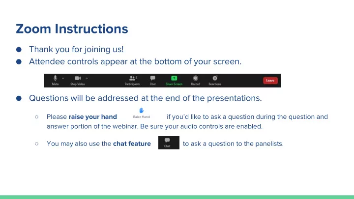
Zoom Instructions Thank you for joining us! Attendee controls - - PowerPoint PPT Presentation

zoom instructions
SMART_READER_LITE
LIVE PREVIEW

Zoom Instructions Thank you for joining us! Attendee controls - - PowerPoint PPT Presentation

Zoom Instructions Thank you for joining us! Attendee controls appear at the bottom of your screen. Questions will be addressed at the end of the presentations. Please raise your hand if youd like to ask a question during


slide-1
SLIDE 1

Zoom Instructions

  • Thank you for joining us!
  • Attendee controls appear at the bottom of your screen.
  • Questions will be addressed at the end of the presentations.

○ Please raise your hand if you’d like to ask a question during the question and answer portion of the webinar. Be sure your audio controls are enabled. ○ You may also use the chat feature to ask a question to the panelists.

slide-2
SLIDE 2

Vegetation Management & Defensible Space Ordinance in El Dorado County

Town Hall Meeting May 14, 2020

slide-3
SLIDE 3

Welcome and Overview of the Town Hall Meeting

slide-4
SLIDE 4

Presententations

  • El Dorado County Vegetation Management Program

Kristine Guth, Program Manager

  • Diamond Springs - El Dorado Fire District

Casey Randsdell, Fire Prevention Officer

  • CAL FIRE – Amador- El Dorado Unit (AEU)

Sherry Moranz, Division Chief

  • El Dorado Hills Fire Department/Rescue Fire Department

Ron Phillips, Fire Marshal/Division Chief

  • Questions
slide-5
SLIDE 5
  • Defensible Space
  • Why Vegetation

Management?

  • Shifting Gears
  • Understanding our

Ordinance

  • Compliance &

Monitoring

  • More Information

EDC Presentation Outline

slide-6
SLIDE 6

Area around a structure where combustible vegetation has been cleared, reduced or replaced. Space that acts as a barrier between a structure and an advancing fire AND between a structure fire and wildland. Fuels should be maintained in a fire-safe condition, year-round.

Defensible Space What is it?

slide-7
SLIDE 7

Why Vegetation Management?

  • Wildfire is a natural part of California’s landscape
  • In recent years, California has experienced large and devastating

wildfires

○ 2018 Camp Fire (Butte County): 86 deaths; 18,804 structures destroyed ○ 2018 Carr Fire (Shasta County): 8 deaths; 1,604 structures destroyed ○ 2017 Thomas Fire (Ventura, Santa Barbara Counties): 23 deaths*; 1,063 structures destroyed *21 deaths attributed to mudslides/debris flow in the burn scar

2017 Tubbs Fire (Napa, Sonoma Counties): 22 deaths; 5,643 structures destroyed

  • El Dorado County fires

○ 2014 King Fire (Pollock Pines, North County): 12 homes destroyed ○ 2014 Sand Fire (South County): 19 homes destroyed ○ 2007 Angora Fire (Meyers and South Lake Tahoe): 254 homes destroyed

slide-8
SLIDE 8

Collective Efforts

  • Vegetation Management

Projects

○ Fire Adapted 50 ○ Utility work ○ Shaded Fuel Breaks ○ Public/Private Partnerships

  • Road Brushing
  • Tahoe Basin
  • Fire Safe Councils
  • Homeowners Associations
  • Community Ordinances
  • City of Placerville
  • And more…
slide-9
SLIDE 9

Understanding Our Ordinance

El Dorado County Ordinance 5101, Chapter 8.09

Problem Identification Policy Cycle Formulation

Evaluation

Implementation Adoption

slide-10
SLIDE 10

EDC Ordinance 5101, Chapter 8.09*

Provides for the removal of hazardous vegetation and combustible materials situated in the unincorporated areas of the county to:

  • Provide enforcement of existing state law (PRC 4291)
  • Build upon the existing grassroots efforts being done

Countywide (e.g. Fire Safe Councils, FA 50, SOFAR, etc.)

  • Reduce the potential for fire, and
  • Promote the safety and well-being of the community

*Effective May 30, 2019; revision approved February 25, 2020

slide-11
SLIDE 11

The Ordinance…

  • DOES NOT require “clear cutting” or “moonscaping”.
  • DOES NOT address fences.
  • DOES NOT address clearing on public lands (e.g.

BLM, Bureau of Reclamation, US Forest Service, etc.)

  • DOES NOT address unimproved parcels/vacant lots

unless some clearance is required based on the good neighbor policy.

  • DOES NOT address roadways* and easements

unless it is the parcel owner’s responsibility and within the required 100 ft.

  • Applies in the unincorporated areas of El Dorado

County (the City of Placerville and South Lake Tahoe have their own ordinances). Additional regulations also apply in Cameron Park and El Dorado Hills.

slide-12
SLIDE 12
  • Vegetation management is an ongoing,

long-term activity

  • Involves presence and dialogue with

residents and landowners

  • Encourage and promote proactive

removal and voluntary compliance

  • Community meetings
  • Information and on-site education (CEAs)
  • Partner with local fire safe councils, fire

districts and others

Measuring Progress

slide-13
SLIDE 13

What does the Ordinance Address? How do I comply?

  • Applies to habitable structures
  • Within 30 feet of all Habitable Structures:

Maintain a roof free of leaves, needles or

  • ther vegetative materials.

Remove any portion of a tree that is within 10 feet of the top of a chimney or stovepipe

  • n a roof.

Remove all dead and dying grass, plants, shrubs, trees, branches, leaves, weeds, etc.

Remove flammable vegetation & items that could catch fire which are next to or below combustible decks, balconies, and stairs.

Remove or separate live flammable ground cover and shrubs.

slide-14
SLIDE 14

You are the Defensible Space Inspector – What do you see?

  • Combustible deck
  • Dead shrub
  • Flammable items (chair

cushion, bench, plastic containers, etc.)

  • Tree branches adjacent

to building/overhanging

  • Live, flammable shrubs

need to be separated

  • r removed
slide-15
SLIDE 15

What does the Ordinance Address? How do I comply?

  • Within 30 – 100 feet of all Habitable

Structures:

Cut annual grasses and forbs (e.g.) to a maximum height of 4 inches.

All exposed woodpiles must have a minimum of 10 feet clearance, down to bare mineral soil in all directions.

Remove dead and dying woody surface fuels and aerial fuels (e.g. tree branches).

Loose surface litter (e.g. fallen leaves, needles, cones, twigs, branches, etc.) permitted to a maximum of 3 inches.

Thin vegetation to create space between clusters of trees (Horizontal spacing).

Remove fuel ladders (Vertical spacing).

slide-16
SLIDE 16

Vertical Spacing Horizontal Spacing

Large trees do not have to be cut and removed, as long as all plants beneath them are removed. This eliminates the fuel ladder. Horizontal spacing depends on the slope of the land and the heighted of the shrubs or trees.

slide-17
SLIDE 17

You are the Defensible Space Inspector – What do you see?

  • Exposed wood pile with

less than 10 feet clearance.

  • Tree clusters
  • Fuel ladders
  • Loose surface litter
slide-18
SLIDE 18

You are the Defensible Space Inspector – What do you see?

  • Fuel ladders
  • Construction debris
  • Shrubs too close

together

slide-19
SLIDE 19

What does the Ordinance Address? How do I comply?

  • Within 100 feet of all Habitable Structures:

Logs or stumps embedded in the soil must be removed or isolated from other vegetation.

  • Other Requirements

Outbuildings and Propane Gas storage tanks shall have 10 feet of clearance to bare mineral soil and no flammable vegetation for an additional 10 feet around their exterior.

Address numbers shall be displayed in contrasting colors (4” min.) and readable from the street or access road.

Chimney and stovepipe openings with a screen between 3/8” and 1/2”.

slide-20
SLIDE 20

You are the Defensible Space Inspector – What do you see?

A cleverly disguised propane tank Flammable Vegetation

slide-21
SLIDE 21

Work with Your Neighbors

Many homes do not have 100’

  • f space between structures

and parcel lines. Property owners are required to maintain defensible space to their property line. Work with neighbors to help provide defensible space for their homes, and ask neighbors for help if their property threatens yours.

In most cases, the most effective solution is a cooperative approach between neighbors.

slide-22
SLIDE 22

2020 Defensible Space Inspections

slide-23
SLIDE 23

Defensible Space Inspections Conducted Annually in El Dorado County

  • CALFIRE does annual 4291 inspections

Countywide

  • Local Fire District defensible space inspections
  • CSD Ordinance inspections (e.g. El Dorado Hills

and Cameron Park)

  • HOA requirements
  • Tahoe Basin requirements
  • City of Placerville Ordinance*
  • El Dorado County Community Emphasis Areas*

* New in 2020

slide-24
SLIDE 24

County Emphasis Areas (CEA)

An area designated by the County for focused, proactive inspections. The County works with CAL FIRE to identify these areas annually.

  • Call volume to a specific area
  • Structural density of an area
  • Ingress/egress
  • Very High Fire Hazard Severity

Zone rating

  • Fire history/ignition history
  • Prevailing weather patterns
  • Wildland Urban Interface (WUI)
  • Topography
  • Existing PRC 4291 data

Methodology and criteria used to determine CEAs

slide-25
SLIDE 25
slide-26
SLIDE 26

2020 Defensible Space Inspections

slide-27
SLIDE 27

2020 CEA: Garden Valley Johntown/Garden Park

  • Beehive Drive
  • Chrysler Circle
  • Garden Park Drive
  • Hancock Court
  • Hancock Road
  • Hollow Oak Court
  • Hood Court
  • Johntown Creek Road
  • Kahala Road
  • Lazy Brook Trail
  • Lynx Ridge Road
  • McKinley Drive
  • Olympus Drive
  • Pyramid Court
  • Pikes Peak Circle
  • Providence Hill Road
  • Rainier Drive
  • Roller Coaster Road
  • Sailor Ridge Road
  • Shaker Lane
  • Shasta Road
  • Tamalpais Road
  • Tedlo Court
slide-28
SLIDE 28

2020 CEA: Pollock Pines Sly Park Area

  • Aerie Road
  • Agate Court
  • Bela Vista Drive
  • Bushwacker Lane
  • Diamond Court
  • Diamond Drive
  • Diolinda Court
  • Garnet Court
  • Garnet Road
  • Gold Ridge Trail (partial)
  • Jenkinson Circle
  • Lakeridge Drive
  • Lakewoods Drive
  • Lava Lane
  • Mountain Lake Drive
  • Nordic Lane
  • Opal Trail (partial)
  • Parkwoods Drive
  • Pearle Road
  • Pine Cone Drive
  • Pine Forest Drive
  • Retreat Lane
  • Sly Park Road (partial)
  • Starkes Grade Road

(partial)

slide-29
SLIDE 29

Compliance & Monitoring: Today through 2020

Ongoing

Community Education County staff, in coordination with Fire Safe Councils, CAL FIRE and local Fire Districts, will provide education to the public and property

  • wners on the ordinance.

February 2020

Notification Letters Properties in the identified areas will be mailed a notice that vegetation must be removed by June 1, 2020. A sample inspection checklist will be included with the letter and posted on the web.

June 1, 2020 & Beyond

Compliance Inspections Inspections will begin in the identified areas:

  • County Emphasis Areas (CEA)
  • Target Hazard Areas (TRA)
  • Wildfire Risk Areas (WRA)

Complaints reviewed and assessed, as appropriate.

slide-30
SLIDE 30

Defensible Space Inspections

Enforcement and Investigative Officials

Enforcement Official: Chief Administrative Officer or Designee Investigative Official: CAL FIRE, Fire Chief of any district in the County or Designee

Inspection(s)

A “Notice of Defensible Space Inspection” report will identify if the property is in compliance with the

  • rdinance or if violations

need to be corrected and a date for re-inspection. Multiple failed inspections will result in a Hazard Abatement Notice.

Enforcement

Violations of the ordinance, may initiate the following:

  • Meet and confer
  • Hazard Abatement

Notice

  • Appeals hearing
  • Forced abatement for

repeated non- compliance

slide-31
SLIDE 31

Where do I start...

...A few options

slide-32
SLIDE 32

Clear Pine Needles from Roofs & Gutters

slide-33
SLIDE 33

Limb Up and Thin Out Smaller Trees

slide-34
SLIDE 34

Chipping and Masticating

slide-35
SLIDE 35

Goatscaping or Targeted Grazing

slide-36
SLIDE 36

Mowing and Trimming

slide-37
SLIDE 37

Other Options for Land Clearing

  • Burn piles (in compliance with

AQMD rules and dates and CAL FIRE permits. Never leave unattended)

  • Eco-friendly sprays or mulching
  • Fire Safe Councils
  • Neighborhood co-op
  • Contractors (ensure they are

licensed and insured)

slide-38
SLIDE 38

Equipment Use Reminders

  • Mow and use equipment

before 10 am

  • Never mow on a hot or

windy day

  • String trimmers are safer
  • ptions than lawn mowers
slide-39
SLIDE 39
slide-40
SLIDE 40

Frequently Asked Questions

  • How do I get my neighbor to

comply with the Ordinance? What if my neighbor is a Local or State Agency?

  • How do I figure out who my

neighbor is?

○ EDC Assessor: 360 Fair Lane, Placerville, 530-621-5719

  • What about vacant parcels?
  • Can the County enter my property

at any time?

  • What resources are available?
  • What is the County doing to clear

roads?

slide-41
SLIDE 41

El Dorado County Ready Together

slide-42
SLIDE 42

Vegetation Management

El Dorado County (530) 621-4663 Vegetation@edcgov.us www.facebook.com/edcpreparedness

www.edcgov.us/government/CAO/VegetationManagement

slide-43
SLIDE 43

Dia iamond Sprin ings – El l Dorado Fir ire Protection Dis istrict

2020 Wildfire Mitigation Plan Emphasis Areas & Expectations

Partners with El Dorado County Vegetation Management and Defensible Space Ordinance No. 5101

Phone: (530) 626-3190 www.diamondfire.org

slide-44
SLIDE 44

Tim imeframes

  • Notification of Wildfire Risk Area Investigation efforts prior to June 1st
  • The County Ordinance refers to inspections as investigations
  • Initial Investigation: commencing after June 1st
  • Education and reasonable plan of actions per property
  • Effective communication between property owners and Investigators
  • Second Investigation: an evaluation of efforts made, and what has been

accomplished

slide-45
SLIDE 45

Kingvale Road Area

  • Roughly 15 Parcels
  • Sizing 5+ Acres Each
  • Lack of Ingress / Egress
  • Overall topography

allows for the heavy potential of wildfire

  • Fire History
slide-46
SLIDE 46

Church Mine Road Area

  • Roughly 25 Parcels
  • Sizing 5+ Acres to 10+

Acres Each

  • Lack of Ingress / Egress
  • Overall topography

allows for the heavy potential of wildfire

  • Fire History
slide-47
SLIDE 47

Finch Road Area

  • Roughly 29 Parcels
  • Sizing ranging from 1+ Acres

to 10+ Acres Each

  • Lack of Ingress / Egress
  • Overall topography allows for

the heavy potential of wildfire

  • Close proximity structure to

structure

slide-48
SLIDE 48

Obje jectives and Goals ls

  • Educate, assist, and gain compliance with property owners
  • On site investigations
  • How the Ordinance applies and effective efforts to meet it
  • Plan of action with reasonable timeframes
  • Goal: Achieve safety with each property
  • Community effort to prevent and prepare for wildfires
  • Encourage property owners to reach out and schedule an inspection

Phone: (530) 626-3190 www.diamondfire.org

slide-49
SLIDE 49

Cameron Park Fire Department What’s the latest?

Ordinance (No. 2020.03.18) updated in March 2020

  • Notable Items:
  • 1. This is Cameron Park’s third year enforcing the ordinance.
  • 2. February notices will no longer be sent out to property owners.
  • 3. Improved and unimproved parcel clearance requirements are clearly identified.
  • 4. Ordinance does not include the good neighbor policy.

Improved Parcels

  • Inspections occurred on 530 lots in April and May, and 30 letters were sent out for non-compliance.

Vacant Parcels

  • First inspections occurred early April. Over 300 parcels were inspected and 200 letters were sent out for non-

compliance.

  • Second inspections occurred early May and 115 letters were sent out for non-compliance.
  • If, by June 1, any improved or vacant parcel remains non-compliant, the hazardous vegetation and rubbish

may be abated and the owner will be responsible for all abatement-related costs incurred by the District.

slide-50
SLIDE 50

El Dorado Hills Fire Department

  • Wildfire Risk Analysis Completed in Spring 2020
  • Six Areas Identified for Defensible Space Inspections (DSI)
  • 400 +/- Parcels Identified for DSI by EDH/Rescue Fire Departments
  • DSI Scheduled to Begin in June 2020
  • Property Owners to Receive Written Notice in Late May Regarding DSI
  • Property Owners Encouraged to Contact Us to Schedule the DSI

916-933-6623 or www.EDHFire.Com

slide-51
SLIDE 51

El Dorado Hills Fire Department

  • Six Wildfire Risk Areas

Scheduled for Defensible Space Inspections

  • Latrobe Hills North Community
  • Latrobe Hills South Community
  • Ryan Ranch – Beaver Pond

Community

  • Salmon Falls Community
  • Salmon Valley Community
  • Kanaka Valley Community
slide-52
SLIDE 52

Questions?

slide-53
SLIDE 53

Panel Members

  • El Dorado County Vegetation Management Program

Kristine Guth, Program Manager

  • Diamond Springs - El Dorado Fire District

Casey Randsdell, Fire Prevention Officer

  • El Dorado Hills Fire Department/Rescue Fire Department

Ron Phillips, Fire Marshal/Division Chief

  • CAL FIRE – Amador-El Dorado Unit (AEU)

Sherry Moranz, Division Chief

  • CAL FIRE – Amador-El Dorado Unit (AEU)

Nate Barcklay, Battalion Chief

  • City of Placerville

Pierre Rivas, Director, Development Services

slide-54
SLIDE 54

El Dorado County Vegetation Management Fire Agency Partners

  • Georgetown Fire , 530-333-4111
  • El Dorado Hills Fire, 916-933-6623
  • CalFire, Amador-El Dorado Unit, 530-683-5229
  • El Dorado County Fire, 530-644-9630
  • Garden Valley Fire, 530-333-1240
  • Diamond Springs-El Dorado Fire, 530-626-3190
slide-55
SLIDE 55
  • Mosquito Fire, 530-626-9017
  • Pioneer Fire District , 530-620-4444

El Dorado County Vegetation Management Fire Agency Partners

  • Lake Valley Fire District , 530-577-3737
  • North Tahoe & Meeks Bay Fire 530-584-2344
  • Rescue Fire Department, 530-677-1868