
SLIDE 1
PUBLIC OPEN HOUSE
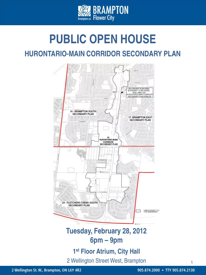
HURONTARIO-MAIN CORRIDOR SECONDARY PLAN Tuesday, February 28, 2012 6pm – 9pm
1st Floor Atrium, City Hall
2 Wellington Street West, Brampton
1
PUBLIC OPEN HOUSE HURONTARIO-MAIN CORRIDOR SECONDARY PLAN Tuesday, - - PDF document
PUBLIC OPEN HOUSE HURONTARIO-MAIN CORRIDOR SECONDARY PLAN Tuesday, February 28, 2012 6pm 9pm 1 st Floor Atrium, City Hall 2 Wellington Street West, Brampton 1 POLICY FRAMEWORK The 2006 Provincial Growth Plan requires that Major Transit
2 Wellington Street West, Brampton
1
support and ensure the viability of existing and planned transit service levels.
development wherever appropriate.
from various transportation modes to the transit facility, including consideration of pedestrians, bicycle parking and commuter pick-up/drop off areas.
accommodate local services, including recreational, cultural and entertainment uses.
implementation of rapid transit.
Gateway Mobility Hub, which will be planned to connect with the regional transit network and accommodate higher density mixed uses (residential, commercial, institutional, etc.)
Blvd area.
2
study between the cities of Brampton and Mississauga to develop a Corridor Master Plan that integrates rapid transit, land use and urban design from Downtown Brampton to Port Credit.
completes Phase One of the Municipal Class Environmental Assessment process, was issued for final comments in October 2010 and a Notice of Completion was issued in January 2011.
http://hurontario-main.ca/masterplan.html
the corridor featuring expanded mobility, vibrant economic activity, and liveable, mixed-use neighbourhoods.
planned urban structure while providing opportunities for mixed-use, compact, intensified Transit-Oriented Development along the corridor.
Rapid Transit service.
3
play
pedestrian networks
and more efficiently.
Hurontario/Main Street to four lanes for auto use and two reserved transit lanes. LRT to operate in shared lanes within segments that are currently four lanes as in the Main Street South Heritage Area.
4
transit solution for Hurontario/Main Street;
Steeles Avenue and Downtown Brampton be confirmed through the completion of planning, design and engineering work including further feasibility for that segment of the Corridor.
the Master Plan be used to draft implementing amendments to the Official Plan and the Comprehensive Zoning By-law and that steps be taken towards approval
Act.
http://hurontario-main.ca/PDFs/masterplan/Brampton.pdf
5
6
Commercial & Institutional);
ground level;
7
and transit focused shopping node at Hurontario and Steeles.
connected civic spaces.
network of open spaces.
canopy.
Washington D.C.
8
9
Corridor Secondary Plan (Area 55)” by including lands within the Hurontario Corridor that are presently part of Secondary Plan Areas 16, 17 and 24;
land use and policy changes intended to transform portions of the Hurontario/Main Corridor from auto-oriented uses to a mixed-use, compact, intensified, transit-oriented development;
and Steeles Ave. intersection including a transit terminal that connects the Hurontario/Main Street transit service to other conventional and higher order transit services;
range of maximum building height from 33 metres (10 storeys) to 78 metres (25 storeys) and a range of maximum density from 2 times site area to 4 times site area;
70% and 95% of the width of the front and/or side lot line;
0 metres and 5 metres; and, include other urban design policies consistent with transit-oriented development that encourage new building forms and attractive private and public spaces.
10
11
12
13
14
15
16
institutional, etc.
and maximum building height of 78 metres.
4 times site area.
from 70% - 75%.
metres to 5 metres.
to create a pedestrian-oriented streetscape.
transit, and prohibit surface parking between the street edge and the front wall of new buildings.
Gross Floor Area or portion thereof.
adjacent residential areas.
17
proposed for the Hurontario/Main Corridor Secondary Plan are intended to implement the long term planning vision for the area, the implementing zoning by-law includes a Holding zone (H) provision that generally allows existing permissions subject to requiring a minimum building height of 2 storeys and a maximum building height of 4 storeys, and requiring higher performance standards with respect to setbacks and continuous building frontage. Lifting of the Holding (H) symbol is dependent upon approval by the Region of Peel of a Functional Servicing Report and fulfillment of
i. commitment of funding for the development of higher
Corridor, which may also include the requirement for a Traffic Impact Study, or,
consideration of higher order transit, to be approved by the Region of Peel and the City of Brampton, if there is no commitment of funding for the development of light rail transit (LRT) infrastructure.
18
19
meetings on planning for the Hurontario-Main Corridor Secondary Plan. Additional meetings will be held with area residents prior to the City proceeding to a statutory public meeting later this year.
comments on the City’s proposal throughout the consultation period. Comments received will be taken into consideration prior to City staff preparing a Recommendation Report on the proposed Official Plan Amendment and Zoning By-law.
Comments can be placed in the drop box provided at this Open House or sent via email, fax or mail. Please see the comment sheet for contact information.
20