Mapping FOSDEM for accessibility The team Laura - - PowerPoint PPT Presentation

mapping fosdem for accessibility
SMART_READER_LITE
LIVE PREVIEW

Mapping FOSDEM for accessibility The team Laura - - PowerPoint PPT Presentation

Mapping FOSDEM for accessibility The team Laura https://codingcatgirl.de/ Created C3NAV Shin Ice Linux Sysadmin (Germany) Fosdem volunteer for different years Johan Van de Wauw Developing sensor solutions at


slide-1
SLIDE 1

Mapping FOSDEM for accessibility

slide-2
SLIDE 2

The team

  • Laura

– https://codingcatgirl.de/ – Created C3NAV

  • Shin Ice

– Linux Sysadmin (Germany) – Fosdem volunteer for different years

  • Johan Van de Wauw

– Developing sensor solutions at Fluves/Marlinks – Freelance data scientist – OSGeo, SAGA-GIS, Debian GIS

slide-3
SLIDE 3

Why

After State of the Map 2016 I'm looking for a volunteer to help FOSDEM make optimal use of OpenStreetMap and make the ULB Solbosch campus openstreetmap mapping

  • exemplary. I'm specificly thinking about indoor maps, wheelchair

accessibility and (hopefully) wheelchair routing. In my dream scenario, I could provide extensive interior mapping data, hand drawn wheelchair routes, pictures if needed and answers to whatever questions may arise, and we would end up with a campus map that allows wheelchair specific routing. Even if that is probably wishful thinking, I'm sure there's some potential for improvement, and I'd be glad to hear about that...

slide-4
SLIDE 4

Openstreetmap

slide-5
SLIDE 5

Openstreetmap

  • Temporary data
  • Floors
  • Wheelchair accessibility
  • Routing

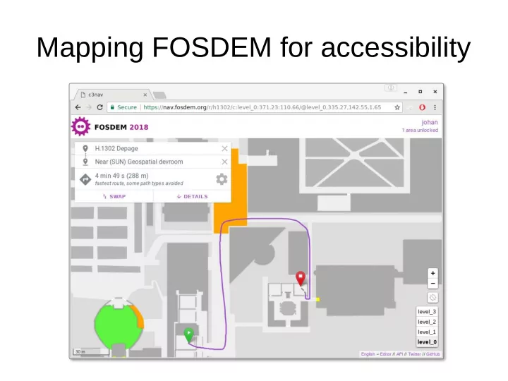
Proposal: use c3nav, an indoor navigation tool built for the CCC conference https://34c3.c3nav.de/

slide-6
SLIDE 6

C3NAV

slide-7
SLIDE 7

Challenges of indoor mapping

  • What is level 0
slide-8
SLIDE 8

Editor

  • (demo)
  • Hierarchic:
  • Level

– Space

  • Area
  • Obstacle
slide-9
SLIDE 9

Graph

slide-10
SLIDE 10

C3NAV supports more than we use

  • Elevation
  • Stairs
  • 3D export
  • Location based on wifi
  • Android app
slide-11
SLIDE 11

Coordinate system

  • Map was not originally projected
  • If we get this right we can use other tools to

work with the data

slide-12
SLIDE 12

Behind the scenes

  • C3NAV

– Python3 (3.6) – Django – Leaflet

  • Optionally

– Postgres – Redis – Celery – Memcached (tiles)

slide-13
SLIDE 13

Want more

  • https://nav.fosdem.org
  • https://nav.fosdem.org/editor/
  • Grab the data:

– https://nav-test.fosdem.org/data

  • Get C3NAV
  • Get our deploy scripts (ansible maps and maps-tileserver

roles)

– https://github.com/FOSDEM/infrastructure/tree/master/ansible/pl

aybooks/roles/maps

– https://github.com/FOSDEM/infrastructure/tree/master/ansible/pla

ybooks/roles/maps-tileserver

slide-14
SLIDE 14

Some stats

  • 3195 unique visitors
  • Approx 100k hits/day
slide-15
SLIDE 15

Discuss

  • Specific needs for a conference make C3NAV

very useful

– Perhaps we can import more from OSM / put data

back?

slide-16
SLIDE 16

Thanks for your attention

slide-17
SLIDE 17

Help clean up!

  • Take everything you see which does not belong here
  • Do the same when going through the corridor
  • If you have some spare time – go to the infodesks and help with

breakdown

  • Let me know if you make a report
  • You can give feedback on talks:
  • https://fosdem.org/2018/schedule/event/geo_fosdem/
  • Johan <at> gisky.be