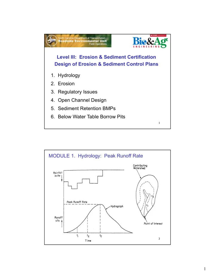
level iii erosion amp sediment certification design of
play

Level III: Erosion & Sediment Certification Design of Erosion - PDF document

Level III: Erosion & Sediment Certification Design of Erosion & Sediment Control Plans 1. Hydrology 2. Erosion 3. Regulatory Issues 4. Open Channel Design 5. Sediment Retention BMPs 6. Below Water Table Borrow Pits 1 MODULE 1.


  1. Level III: Erosion & Sediment Certification Design of Erosion & Sediment Control Plans 1. Hydrology 2. Erosion 3. Regulatory Issues 4. Open Channel Design 5. Sediment Retention BMPs 6. Below Water Table Borrow Pits 1 MODULE 1. Hydrology: Peak Runoff Rate 2 1

  2. Watershed Delineation • Water runs down slope and crosses contour lines perpendicular • Point of Interest (POI) is the location of a BMP (e.g. sediment basin) • Most Remote Point (MRP) is the most distant point on the watershed boundary • Watershed drainage area is the total land area that drains to POI (determined from a map) USGS Topo Maps: topomaps.usgs.gov ACME Mapper: mapper.acme.com 3 Watershed Delineation 2ft contours 1 1 in.=200ft 4 2

  3. Runoff Hydrograph Estimation Methods Runoff Hydrograph Two common methods: Peak Q = 60 cfs Rational Method: Peak Runoff Rate Soil-Cover-Complex (SCS): Runoff Volume Peak Runoff Rate Never combine these methods t c = 6.2 minutes 5 Rational Method for Estimating Peak Runoff Rate Q = (C) (i) (A) (Equation 1.1) Q = peak runoff or discharge rate in cubic feet per second (cfs), C = Rational Method runoff coefficient (decimal ranging from 0 to 1), i = rainfall intensity for a given return period in inches per hour (in/hr), and A = watershed drainage area in acres (ac). 10-year peak runoff, Q 10 = 30 cfs Examples: 25-year peak runoff, Q 25 = 45 cfs 6 3

  4. Return Period & Exceedance Probability T = 1 / P (Equation 1.2) P = probability of a precipitation event being exceeded in any year, T = return period for a specific hydrologic event (years). Return period for a rainfall event that has a 0.10 (10%) Example: probability of being exceeded each year is: T = 1 / 0.10 = 10-yr return period Return period for a rainfall event that has a 0.04 (4%) Example: probability of being exceeded each year is: T = 1 / 0.04 = 25-yr return period 7 Time of Concentration, t c Time for water to travel from the Most Remote Point (MRP) to the Point of Interest (POI) MRP Methods for estimating t c 1. Jarrett Shortcut Method 2. Segmental Method (TR-55) L H Need to Know: 1. Watershed Area, A (acres) 2. Flow Length from MRP to POI, L (ft) 3. Elevation Drop from MRP to POI, H (ft) POI 4. Land Use (assume graded, unpaved) 8 4

  5. Jarrett Shortcut Method: t c S = H / L flow (Equation 1.3) S = average watershed slope (ft/ft), H = elevation change from most remote point to point of interest (ft), and L flow = flow length from most remote point to point of interest (ft). A Jarrett = 460 (S) (Equation 1.4) A Jarrett = Jarrett Maximum Area in acres (ac), and S = average watershed slope (ft/ft). If the watershed area is less than the Jarrett Maximum Area, then t c = 5 min 9 Jarrett Shortcut Method: t c Example : For a watershed drainage area of 5 acres with an elevation drop of 10 ft over a flow length of 500 ft, what is the average slope and the Jarrett Maximum Area? Slope, S = H / L flow = 10 / 500 = 0.02 ft/ft Jarrett Max Area, A Jarrett = 460 (0.02) = 9.2 acres Since the watershed drainage area of 5 acres < 9.2 acres, use t c = 5 min Example : For a watershed drainage area of 7 acres with an elevation drop of 8 ft over a flow length of 720 ft, what is the average slope and the Jarrett Maximum Area? Slope, S = H / L flow = 8 / 720 = 0.011 ft/ft Jarrett Max Area, A Jarrett = 460 (0.011) = 5.1 acres Since the watershed drainage area of 7 acres > 5.1 acres, the Jarrett Shortcut does not apply, and a different method must be used. 10 5

  6. NRCS Segmental Method (TR-55) Shallow Concentrated Flow Unpaved Areas: t c = 0.001 (L flow ) / S 0.53 (Equation 1.5) Paved Areas: t c = 0.0008 (L flow ) / S 0.53 (Equation 1.6) t c = time of concentration in minutes (min), L flow = flow length from most remote point to point of interest (ft), S = average watershed slope (ft/ft). Note: Kirpich (1940) is another methods 11 NRCS Segmental Method (TR-55) Shallow Concentrated Flow Example : For a construction site watershed drainage area of 10 acres with an elevation drop of 12 ft over a flow length of 1000 ft, estimate time of concentration. Slope, S = H / L flow = 12 / 1000 = 0.012 ft/ft Assume that the area is unpaved, therefore use Equation 1.5: t c = 0.001 (L flow ) / S 0.53 = 0.001 (1000) / 0.012 0.53 = 10.4 minutes Use t c = 10 minutes If the elevation drop for this site was 30 ft, the calculated value for t c would be 6.4 minutes. It that case, use a t c value of 5 minutes for determining rainfall intensity since the lower t c produces a higher rainfall intensity and a more conservative estimate of peak runoff rate and basin size. 12 6

  7. Rainfall Intensity (in/hr): Table 1.1 http://hdsc.nws.noaa.gov/hdsc/pfds/pfds_map_cont.html?bkmrk=nc 13 Rainfall Data Need Intensity by Return Period and Duration Listed for some locations in Table 1.1 POINT PRECIPITATION FREQUENCY (PF) ESTIMATES WITH 90% CONFIDENCE INTERVALS AND SUPPLEMENTARY INFORMATION NOAA Atlas 14, Volume 2, Version 3 PF tabular PF graphical Supplementary information Print Pa AMS-based precipitation frequency estimates with 90% confidence intervals (in inches/hour) 1 Annual exceedance probability (1/years) Duration 1/2 1/5 1/10 1/25 1/50 1/100 1/200 1/500 5.18 6.34 7.14 7.92 8.46 8.94 9.34 9.79 5-min (4.76฀ 5.66) (5.83฀ 6.91) (6.54฀ 7.76) (7.22฀ 8.63) (7.68฀ 9.19) (8.08฀ 9.72) (8.40฀ 10.2) (8.74฀ 10.7) 4.15 5.08 5.71 6.31 6.73 7.10 7.41 7.75 10-min (3.82฀ 4.53) (4.67฀ 5.54) (5.23฀ 6.22) (5.76฀ 6.87) (6.11฀ 7.33) (6.41฀ 7.72) (6.66฀ 8.07) (6.91฀ 8.45) 3.48 4.28 4.81 5.33 5.68 5.98 6.23 6.50 15-min (3.20฀ 3.80) (3.94฀ 4.68) (4.41฀ 5.24) (4.87฀ 5.81) (5.16฀ 6.18) (5.40฀ 6.51) (5.60฀ 6.79) (5.80฀ 7.09) 2.40 3.04 3.49 3.95 4.28 4.58 4.85 5.18 30-min (2.21฀ 2.63) (2.80฀ 3.32) (3.20฀ 3.80) (3.61฀ 4.30) (3.89฀ 4.66) (4.14฀ 4.98) (4.36฀ 5.29) (4.61฀ 5.64) 1.51 1.95 2.27 2.63 2.90 3.16 3.40 3.71 60-min 14 (1.39฀ 1.65) (1.79฀ 2.13) (2.08฀ 2.47) (2.40฀ 2.86) (2.63฀ 3.16) (2.85฀ 3.43) (3.06฀ 3.71) (3.31฀ 4.05) 0 882 1 15 1 35 1 59 1 77 1 95 2 13 2 35 7

  8. Runoff Coefficient, C Table 1.2. Rational Method C for Agricultural Areas. (Taken from Schwab et al., 1971). Vegetation Runoff Coefficient, C Slope Sandy Loam Clay and Silt Loam Tight Clay Forest 0-5% slope 0.10 0.30 0.40 5-10% slope 0.25 0.35 0.50 10-30% slope 0.30 0.50 0.60 Pasture 0-5% slope 0.10 0.30 0.40 5-10% slope 0.16 0.36 0.55 10-30% slope 0.22 0.42 0.60 Cultivated 0-5% slope 0.30 0.50 0.60 5-10% slope 0.40 0.60 0.70 10-30% slope 0.52 0.72 0.82 15 Area-Weighted Average C value Example : Determine the weighted average runoff coefficient, C, for a 4-acre watershed with 1 acre of grassy field on clay soil at 3% slope and 3 acres of active construction on clay soil at 4% slope. Land Cover A C (A) (C) Pasture 1 0.40 0.40 Bare Soil 3 0.60 1.80 TOTAL sum = 4 sum = 2.20 Weighted C = 2.20 / 4 = 0.55 For this example, estimate Q if rainfall intensity, i = 5.80 in/hr: Q = (C) (i) (A) = (0.55) (5.80) (4) = 12.8 cfs 16 8

  9. Example: Rational Method Determine the 10-year peak runoff rate, Q 10 , for a 5-acre construction site watershed near Asheville with a flow length = 600 ft and elevation drop = 36 ft. The land uses are shown below: Weighted Runoff Coefficient: C = 3.10 / 5 = 0.62 Average watershed slope, S = 36 / 600 = 0.06 ft/ft Jarrett Max Area = 460 (0.06) = 27.6 ac; Since 5 < 27.6, use t c = 5 min Rainfall intensity for 10-year storm, i 10 , is determined from Table 1.1 for a 5-minute rainfall in Asheville: i 10 = 6.96 in/hr 17 Peak runoff rate, Q 10 = (0.62) (6.96) (5) = 21.6 cfs Example: Rational Method Determine the 25-year peak runoff rate, Q 25 , for a 4-acre construction site watershed near Charlotte with a flow length = 500 ft and elevation drop = 20 ft. The Runoff Coefficient, C = 0.60 (cultivated tight clay soil) Average watershed slope, S = 20 / 500 = 0.04 ft/ft Jarrett Max Area = 460 (0.04) = 18.4 ac; Since 4 < 18.4, use t c = 5 min Rainfall intensity for 25-year storm, i 25 , is determined from Table 1.1 for a 5-minute rainfall in Charlotte: i 25 = 8.00 in/hr Peak runoff rate, Q 10 = (0.60) (8.00) (4) = 19.2 cfs 18 9

  10. Worksheet 1.1 Estimate the 25-year return period peak runoff rate from a watershed near Greensboro that is 5x1.96 inches on a map (scale: 1inch=200ft). The watershed has an average slope of 5.5% and a weighted average runoff coefficient of 0.65. C = 0.65 A = 9 ac (1000ft x 392 ft) t c = 5 min [A Jarrett = 460 (0.055) = 25 which is greater than 9] i 25 = 7.46 in/hr (Table 1.1) Q 25 = (C) (i) (A) = (0.65) (7.46 in/hr) (9 ac) = 44 cfs 19 Worksheet 1.2. Estimate the 10-year peak runoff rate, Q 10 , for a 20-acre construction site watershed near Raleigh with a flow length = 2000 ft and elevation drop = 60 ft. The land uses are half forest and half bare soil. Assume tight clay. Land Use A C (A) (C) Forest 10 0.40 4.0 Bare soil 10 0.60 6.0 sum = 20 ac sum = 10.0 Weighted Runoff Coefficient: C = 10 / 20 = 0.5 Average watershed slope, S = 60 / 2000 = 0.03 ft/ft Jarrett Max Area = 460 (0.03) = 13.8 ac; Since 13.8 < 20, use other method Segmental Method: t c = 0.001 (2000) / 0.03 0.53 = 12.8 min; use t c = 10 min Rainfall intensity, i 10 = 5.58 in/hr Peak runoff rate, Q 10 = (0.5) (5.58) (20) = 56 cfs 20 10

Download Presentation
Download Policy: The content available on the website is offered to you 'AS IS' for your personal information and use only. It cannot be commercialized, licensed, or distributed on other websites without prior consent from the author. To download a presentation, simply click this link. If you encounter any difficulties during the download process, it's possible that the publisher has removed the file from their server.

Recommend


More recommend