Information about the site we need to take into account Before we - - PowerPoint PPT Presentation

information about the site we need to take into account
SMART_READER_LITE
LIVE PREVIEW

Information about the site we need to take into account Before we - - PowerPoint PPT Presentation

Site considerations Information about the site we need to take into account Before we start designing a new scheme, we complete ACCESS AND MOVEMENT ACCESS AND MOVEMENT Access & Movement We have looked at the pattern of roads around the


slide-1
SLIDE 1 0 10 100 200M N Scale 1:5000@A3

Access & Movement

+11.5 +11 +10.5 +10 +9.5 +12 +12.5 +9.0 9.0 +9

0 10 50 100M N Scale 1:2500@A3

Environment & Site features

Woodland TPO tree Hedgerow Flood Zone 2 Contours (0.5m intervals) Listed Buildings Scheduled Archaeological Monument Archaeological Protection Area Site Boundary Noise Contour NEC A Noise Contour NEC B

EAST WEST South-West prevailing wind direction SUN PATH

Mature tree

ACCESS AND MOVEMENT We have looked at the pattern of roads around the site, the best places to get in and out and connections to the surrounding area for cars, cycles and pedestrians. We have also looked at the provision of public transport around the site. We will use this information to design the entrances, key streets, cycleways and paths for the development and look at how public transport can be integrated with the scheme. ENVIRONMENT We have looked at all the environmental features on and around the site. This will tell us which need to be protected and incorporated into our design as well as identify potential problems such as fmooding or noise which will require an appropriate design solution.

Stream on the western boundary. View of the castle. Historic hedgerows. Adjacent primary school.

Things to think about

Before we start designing a new scheme, we complete an assessment of the site and the surrounding area as they are at the moment. We record those features we will need to take into account in our design. All of the relevant considerations, whether they fjx the way

  • ur scheme will have to be designed or give us a real
  • pportunity to make the most of a particular feature,

are shown here.

1 3 5 7 9 11 2 4 6 8 10 12

Good pedestrian access to local facilities. Linking the site into the local walking network. Looking at sustainable transport options. Looking at the capacity of key road junctions and undertaking necessary improvements. Providing ample parking onsite. The variety of characteristic historic buildings.

Information about the site we need to take into account

Site considerations

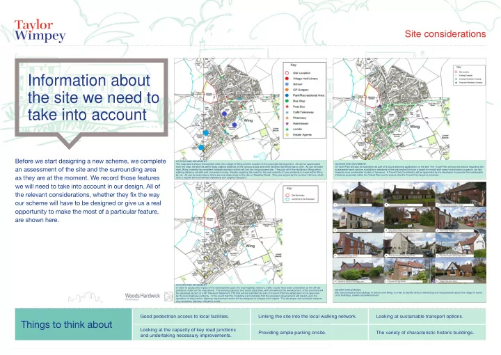
ACCESS AND MOVEMENT The map above shows the facilities within the village of Wing and the location of the proposed development. As can be appreciated from the map, the site lies within easy walking distance of the various shops and other facilities that Wing has to offer. As can be seen right, Wing currently has excellent footpath provision which will link into the proposed site. This puts all of the facilities in Wing within walking distance via safe and convenient routes, thereby negating the need for the vast majority of new residents to travel within Wing by car. As can be seen above, there are bus stops close to the site on Stewkley Road. They are served by the number 165 bus, which runs a regular service between Aylesbury and Leighton Buzzard. ACCESS AND MOVEMENT A Travel Plan will also be submitted as part of a future planning application on the site. The Travel Plan will provide advice regarding the sustainable travel options available to residents of the site and will include a target for modal shift away from single occupancy car use towards more sustainable modes of transport. A Travel Plan Coordinator will be appointed by the developer to promote the sustainable initiatives proposed within the Travel Plan and to ensure that the Travel Plan target is achieved. ACCESS AND MOVEMENT In order to assess the impact of the development upon the local highway network, traffjc counts have been undertaken at the off-site junctions circled on the map above. The existing capacity and future capacities, with and without the development, of the junctions will be assessed as part of a full Transport Statement (TS) that will be submitted as part of a future Planning Application to be approved by the local Highway Authority. In the event that this modelling demonstrates that the proposed development will impact upon the

  • peration of the junction, highway improvement works will be designed to mitigate their impact. The developer will contribute towards

any necessary highway mitigation works. DESIGN INFLUENCES We have looked at the buildings in and around Wing, in order to identify what is interesting and characteristic about the village in terms

  • f its buildings, streets and environment.
slide-2
SLIDE 2

A distinctive character. Safe, convenient and direct paths & cycle routes. Making the most of the land and existing features. Access to existing facilities. Well located, well managed open space. Finding your way around.

How we approached the design of the site

Design process

Things we took into account

We use the site considerations to help us produce design proposals. It is important that the design process takes full account of the physical features

  • f the site, its setting and connections to its
  • surroundings. Our new development must also take

into account the existing character of the local area.

MOVEMENT IN AND AROUND THE SITE We have looked at the pattern of roads around the site, the best places to get in and out and the most desirable routes for cars, cycles and pedestrians both across and around our site. We used this information to design the entrances, key streets, cycleways and paths for the scheme. THE DESIGN OF THE NEW HOMES The distinctive characteristics of Wing have strongly infmuenced these early design sketches for the architecture of the new homes, in order to make the new development feel part of the village and to ensure that the buildings will be high quality and attractive. PUBLIC AND OPEN SPACE We have looked at what the areas around our proposed scheme are used for, the boundaries of the site and the physical features

  • f the land itself to identify the most appropriate place for open spaces. the pattern of streets, pedestrian and cycle routes help us to

decide where we could form features such as squares and junctions. We then consider how the different buildings can frame those streets.

Stewkley Road High Street Dormer Avenue Primary on site road loop Secondary access route Private driveways New pedestrian crossing Pedestrian access green corridor Trim trail Public open space Intersecting routes Vehicular & pedestrian movement corridor connecting views of open space Pedestrian green access Long distance views Vehicular access

slide-3
SLIDE 3

Key Facts

This former allotments site at the corner of Stewkley Road and Dormer Avenue is identifjed by Aylesbury Vale District Council as a suitable development site which is capable of accommodating approximately 50 new homes. In October 2013 this site was also part of the Parish Council’s consultation, and was considered by attendees to be the best site for development. The Parish Council have advised us that there are three main topics that they are keen to see addressed:

  • Retaining the existing green spaces, and creating an ecological

corridor to the open countryside.

  • Ensuring there is enough parking for the new homes, to make sure

existing residents of Wing are not affected.

  • The traffjc implications of the new homes.

We will design the scheme with these matters in mind and will ensure that mature trees and hedgerows are retained, with the western element of the site providing an ecological and wildlife corridor, acting as a screen to the development and reducing the potential visual impact upon the existing landscape. Car parking will be provided which will meet the Council’s parking standards, and the traffjc implications will be studied in detail and works to the highway network in and around Wing will be undertaken where necessary. Taylor Wimpey will discuss the scheme with the local community of Wing again, once the proposals have been progressed further. This will be prior to the submission of any planning application for the site. Please feel free to share your thoughts with members of the team, as your views will help to shape the form of this new development.

Site accessed from Dormer Avenue. Ecological buffer a key part of the proposals. Parking provided to meet local standards. Green spaces retained and enhanced. Attractive pedestrian link through the site. Open, green feel to the development.

Our designs for the Stewkley Road Allotments site

Scheme proposal

slide-4
SLIDE 4

Key Facts

Preliminary design concepts for the site. 2-storey houses, mostly with garages. Street trees and landscaping giving a rural feel to the streets and spaces. Streets and houses which will fjt with the character of the village. A spacious feel, particularly where the buildings overlook the woodland. An attractive, safe environment which will enhance the village.

Our designs for the Stewkley Road Allotments site

Scheme proposal

slide-5
SLIDE 5

Key Facts

Views to Castle Hill and Church retained. Existing Boundary Vegetation retained. Retained Boundary vegetation provides good visual barrier. Existing Footpath retained. Western Boundary Provides Ecological Green Link. Landscape Character features retained.

Our designs for the Stewkley Road Allotments site

Design process

slide-6
SLIDE 6

Key Facts

Woodland retained and enhanced for wildlife. Existing pathway retained and enhanced. Informal Tree Lined streets creating a rural feeling. Wooden Play area provided. Green links formed from Dormer Avenue to retained woodland. Safe pedestrian link to High Street.

Our designs for the Stewkley Road Allotments site

Scheme proposal