
SLIDE 1
CHISWICK CURVE SITE CONTEXT North Circular Road M4 / Great West - - PowerPoint PPT Presentation
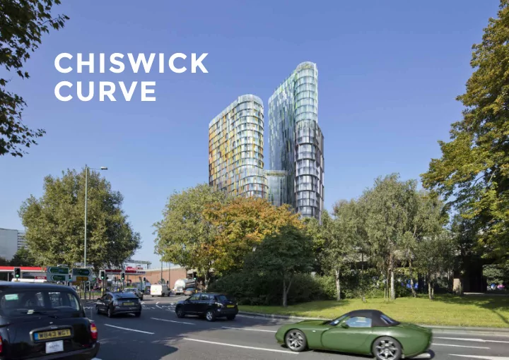
CHISWICK CURVE SITE CONTEXT North Circular Road M4 / Great West Road (A4) Site Chiswick High Road Chiswick Roundabout South Circular Road Kew Bridge Station Aerial view illustrating the sites setting Development Context The Golden
Site
Kew Bridge Station M4 / Great West Road (A4) Chiswick High Road North Circular Road South Circular Road Chiswick Roundabout
Aerial view illustrating the sites setting
Development Context
The Golden Mile: The Beginning
reduce high levels of unemployment after WWI
to construct their iconic Art Deco buildings along the corridor
Wallis House, originally designed by Wallis, Gilbert and Partners The Firestone Factory, by Wallis, Gilbert and Partners The Gillette Factory, by Sir Banister Flight Fletcher
Development Context
The Golden Mile: Present Day
A4 A4 M4 M4 M4 M4 1 3 4 7 6 8 9 10 5 2
multi-national companies such as Glaxo-Smith Kline, Sky, and Mercedes.
Site Location
SITE M4 FLYOVER CHISWICK ROUNDABOUT LARCH DRIVE B & Q GUNNERSBURY CEMETERY WHEATSTONE HOUSE VW SHOWROOM ESSO BRENTFORD FOUNTAIN LEISURE CENTRE KEW HOUSE SCHOOL NORTH CIRCULAR ROAD A 4 G R E A T W E S T R O A D CHISWICK HIGH ROAD SOUTH CIRCULAR ROAD W E L L E S L E Y R O A D
since 1990s
the Golden Mile
the North and South Circular Road, Chiswick High Road, Great West Road (A4), and the M4 motorway
Heathrow Airport and Central London
elevated M4 Flyover.
View 1 Existing unoccupied Site View 2 Traffjc at Chiswick Roundabout Keyplan View 3 Low quality paving around the Site View 1 Undercroft of the M4
4 2 1 3
Existing Local Character
Development Summary
Summary
workspace
landscaped atrium
car club, 70 residential)
484 residential, 2 Retail/cafe) Scheme Benefjts
the site
principal junctions and underpass
uses
integrated into architectural facade
Basement Residential Playspace Creative Workspace Terrace Creative Workspace Communal Hub Gallery Café Atrium
Illustrative Design Development Section through the Ground Floor and Offjce Workspace Levels
Residential Residential Playspace Offjce Workspace Offjce Terrace Retail Atrium Basement Plant / Refuse
Section through the Lower Floors
The ground fmoor comprises the double height publically accessible atrium, three residential lobbies, fmexible retail A1/A3 space, cycle lobbies, and ancillary space.
ATRIUM A1/A3 A1/A3 RESIDENTIAL LOBBY RESIDENTIAL LOBBY RESIDENTIAL LOBBY REFUSE HOLDING AREAGround Floor
Illustrative View of the Publically Accessible Atrium
The workspace fmoors offer high quality, fmexible
which provide communal facilities, such as double-height event spaces between levels.
Offjce Workspace
Offjce Workspace
Illustrative View of the Creative Workspace Interior
Public Realm & Landscape Design Principles
06 Provide play
07 Extend and improve the
existing cycle network
08 Promote a sustainable
landscape
09 Provide a seamless
integration of landscape and architecture
10 Provide a publicly
accessible roof garden
01 Strengthen Pedestrian
Connections
02 Sculpt a new public space 03 Humanise the environment 04 Create shelter from wind
and noise
05 Amplify nature inside
and out
B B C C C C C C B B A
Essential public realm and highway works within the application boundary: Section 278 highway works to crossings and key connecting spaces: Aspirational public realm and Landscape works to improve the wider environment
B C A
Illustrative Wider Landscape & Public Realm Improvements
Illustrative Wider Landscape & Public Realm Improvements
Sketch illustrating initial thoughts for the pedestrian approach towards the arrival space from the South West
A composition of three forms on a triangular site Two slender forms from Gunnersbury Cemetery view Steps clustered around the middle datum
Massing Concept
120.290 AOD (East building Volume Lift Overrun) 109.005 AOD (West building Volume Lift Overrun)
Building Height
West Elevation
Photo of Strand on the Green which inspired the earth tone colour palette for the building (Image: Strand On The Green Association)
Appearance
Facade Overview
Vertical fjns Wedged balcony Digital advertising Feature coloured glass Feature coloured glass shadow box Horizontal fjns
Illustrative View from Chiswick Roundabout (South)
Illustrative View from Chiswick High Road
Detail of Digital Advertising along the M4
Site Prevailing Winds
Sustainability
conjunction with sustainability and energy consultants, XCO2 Energy to explore, identify and optimise the environmental and energy performance of the Development
and building orientation and responds to constraints including noise and air quality
and LBH’s Local Plan (Substantive Version Part 1 - May 2015)
by 33.9% (when compared to Part L of the Building Regulations (2013) and will meet the London Plan of 35% through carbon offset payment
Construction rating of ‘Excellent’
ensure a fabric-led approach to sustainability including a parametric facade study and solar radiation analysis to inform the design and integration of solar shading elements
The Proposed Development has been designed with a holistic sustainability strategy to deliver a socially and environmentally responsible scheme
5+ 4.5 4.0 3.5 3.0 2.5 2.0 1.5 1.0 0.5 0.0 Average Daylight Factor (%)
Site layout and building orientation Computational modelling to sunlight and daylight in apartments
1 3 10 14 15 11 6 4 2 7 8 9 12 13 5
Sustainable Features
1 Rainwater Harvesting 2 Photovoltaic Panels 3 Sedum Roof Planting 4 High-Performance Glazing 5 Insulated Cladding Panels 6 Solar Shading Fins 7 Heat Recovery in Apartments 8 Acoustic Consideration 9 High Glazing Specifjcation for Offjce Levels 10 Rainwater Attenuation 11 Biodiversity & Planting 12 Amenity Spaces 13 Improved Cycle Connections 14 Combined Heat and Power System 15 Water Effjcient Appliances and Fixtures
Sustainability
Key Plan
Hounslow Conservation Areas Ealing Conservation Areas Proposed Conservation Areas World Heritage Site World Heritage Site Buffer Zone Borough Boundary Site Grade I Listed Building Grade II* Listed Building Grade II Listed Building Locally Listed Parks and Gardens Richmond Conservation Areas
View 2 - Gunnersbury Park, The Round Pond (Looking South)
View 4 - Gunnersbury Cemetery (Looking Southeast)
View 10 - Kew Bridge Road, Junction with Kew Road (Looking Northeast)
View 13 - Kew Bridge, South End (Looking North)
View 21 - Kew Green (Looking North)