
SLIDE 1
water quantity limits for managing water takes at low flows - - PowerPoint PPT Presentation
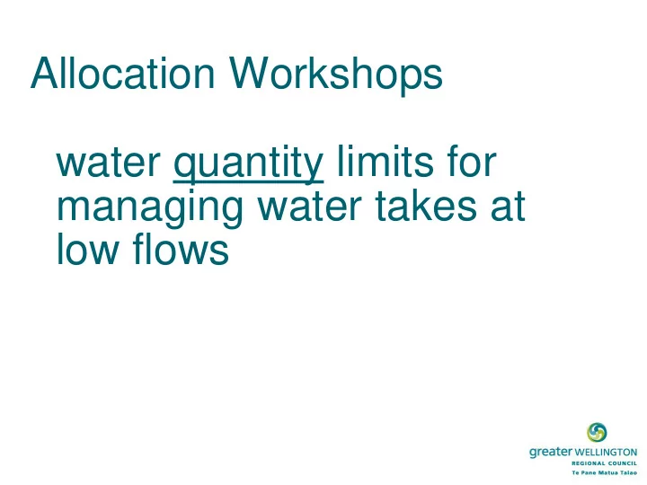
Allocation Workshops water quantity limits for managing water takes at low flows Purpose Refresh on the modelling work Confirm flow dependent values Confirm subset of values that can be modelled, surrogates Think about
River Minimum flow (L/s) Flow at which non- essential takes cease (L/s) MALF 7 day (L/s) * = estimate Minimum flow as proportion of MALF Kopuaranga River 270 310 87% Waipoua River 250 375 67% Waingawa River 1100 1700 1420 77%, 120% Parkvale Stream 100 140* 71% Mangatarere Stream 240, 200 165 145%, 120% Waiohine River 2300 3040 3570 64%, 85% Papawai Stream 180 210 86% Upper Ruamahanga River 2400 3605* 68% Otukura Stream 95 100 95% Tauherenikau River 1100 1300 1350 96% Lower Ruamahanga River 8500 12565* 68%
River Allocation (L/s) MALF 7 day (L/s) * = estimate Allocation as proportion of MALF Kopuaranga River 150 605 25% Waipoua River 129 490 26% Waingawa River 920 1835 65% Parkvale Stream 151 140* 108% Mangatarere Stream 473 330 143% Waiohine River 1005 3180 32% Papawai Stream 340 210 160% Upper Ruamahanga River 954 2400* 40% Otukura Stream 140 100 140% Tauherenikau River 233 820 28% Whole Ruamahanga River 8046 12565* 64%
Comment from community member Location feedback received Need to protect favourite swimming holes. Greytown Increase in slime in the Waiohine further down. Greytown 15 years ago was full of fish, but now muddy Moroa water race. Greytown Waihenga Bridge – 12 years ago everyone swum there. Then people
Martinborough Kayaked down The Ruamahanga river - Te Ore Ore Bridge. Seen slime on the bottom. Passed Wardells – river was very low. The worst part is the Cliffs – people scared to swim after the publicity. Rivers are not as dirty as the media say. Carterton Cliffs in high flows aren’t swimmable because MDC releases from the wastewater treatment plant. Whangaehu Lost deep pools due to flood protection although less rubbish. Gladstone Waipoua – Ruamāhanga confluence not swimmable. Gladstone At our place you’ll swim in mud (North of Mauriceville). Kopuaranga In places where willows have been removed you can now see the stones in the river – rivers moving quickly. The spots we go to are important. Focus on them. Kopuaranga
Relative sub catchment value based on predicted distribution of native fish