SLIDE 1 Creamer’s Field
- 1. Permafrost Tunnel
- 3. APEX
- 2. Farmer’s Loop
Goldstream Tanana Flats fire scars 1930, 1970, 1985, 2001, 2010
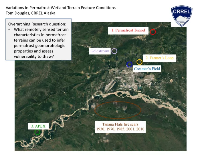
Variations in Permafrost Wetland Terrain Feature Conditions Tom Douglas, CRREL Alaska Overarching Research question:
- What remotely sensed terrain
characteristics in permafrost terrains can be used to infer permafrost geomorphologic properties and assess vulnerability to thaw?
SLIDE 2 Creamer’s Field
- 1. Permafrost Tunnel
- 3. APEX
- 2. Farmer’s Loop
Goldstream Tanana Flats fire scars 1930, 1970, 1985, 2001, 2010
Variations in Permafrost Wetland Terrain Feature Conditions Airborne LiDAR in 2014 and 2016 Airborne hyperspectral in 2016 Historical imagery to 1949 UAV testing and spectral meas. Ground based LiDAR
- Veg. spectral reflectance
Repeat thaw depths/active layer dGPS surveying Vegetation assessments Vegetation manipulations Moisture content, pH, Eh Microbiology Thermal measurements Electrical resistivity tomography Snow surveys Coring to 15 m depth
SLIDE 3 Permafrost Tunnel- thermokarst driven hydrologic change Gently sloping upland terrain. 10m high ice wedges covered by ~3m of silt Advanced thermokarst hydrologic change Downslope sedimentation/redistribution
Permafrost Tunnel
Initiation of thermokarst In the last few years June-September Precipitation: 2014: 223% above mean 2015: 156% above mean 2016: 183% above mean
SLIDE 4
Farmer’s Loop- Worldview 2 image and repeat LiDAR 2014-2016 LiDAR (meters) 500 m 500 m
SLIDE 5
Farmer’s Loop- Worldview 2 image and galvanic electrical resistivity tomography 500 m
140 120 60 20 E levation in meters 100 80 40
E lectrode spacing 6 meters R MS error: 16.4
R esistivity in ohm-me ters 100 200 400 800 1600 3200 6400 12,800
Trail Trail Distance in meters 200 100 300 400 500
Birch-white Spruce forest WC: 30-100 g/g Treed fen WC: 30-100 g/g Tussocks and shrubs WC: 100-800 g/g Black spruce/moss forest WC: 30-100 g/g
SLIDE 6
Birch-white Spruce forest WC: 30-100 g/g Treed fen WC: 30-100 g/g Tussocks and shrubs with increasing shrub density WC: 100-800 g/g Black spruce/moss forest WC: 30-100 g/g
Repeat thaw depth measurements along four 500 m long dGPS surveyed transects- one summer Trail Trail Farmer’s Loop
SLIDE 7
Birch-white Spruce forest WC: 30-100 g/g Treed fen WC: 30-100 g/g Tussocks and shrubs with increasing shrub density WC: 100-800 g/g Black spruce/moss forest WC: 30-100 g/g
Trail Trail Farmer’s Loop
SLIDE 8
Birch-white Spruce forest WC: 30-100 g/g Treed fen WC: 30-100 g/g Tussocks and shrubs with increasing shrub density WC: 100-800 g/g Black spruce/moss forest WC: 30-100 g/g
Trail Trail Farmer’s Loop
SLIDE 9
Trail Trail
Birch-white Spruce forest WC: 30-100 g/g Treed fen WC: 30-100 g/g Tussocks and shrubs with increasing shrub density WC: 100-800 g/g Black spruce/moss forest WC: 30-100 g/g
Tussock site: 60 cm <0°C in mid November Farmer’s Loop
Transition zone Ice cemented silt
SLIDE 10
Trail Trail
Birch-white Spruce forest WC: 30-100 g/g Treed fen WC: 30-100 g/g Tussocks and shrubs with increasing shrub density WC: 100-800 g/g Black spruce/moss forest WC: 30-100 g/g
Repeat thaw depth measurements along four 500 m long dGPS surveyed transects- 4 years Similar repeat patterns across all four transects Farmer’s Loop
SLIDE 11 2015 2016 2015 2016 2016
Depth in cm 10 20 30 40 50 60 70 80 90 100
APEX site- snow depths in 2015 and 2016- repeated patterns of ecotype/terrain-snow relationships
- Hoping to have IceBridge fly all sites in March, 2017 coincident with a large snow campaign
Thomas.a.douglas@usace.army.mil