Upper Thames River Conservation Authority Harrington Hall and - - PowerPoint PPT Presentation

upper thames river conservation authority harrington hall
SMART_READER_LITE
LIVE PREVIEW

Upper Thames River Conservation Authority Harrington Hall and - - PowerPoint PPT Presentation

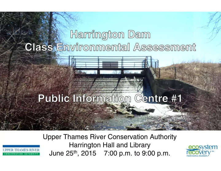
Upper Thames River Conservation Authority Harrington Hall and Library June 25 th , 2015 7:00 p.m. to 9:00 p.m. Harrington Dam Study Area Harrington Dam was acquired by UTRCA in 1952, and the dam was repaired and the pond enlarged shortly


slide-1
SLIDE 1

Upper Thames River Conservation Authority Harrington Hall and Library June 25th, 2015 7:00 p.m. to 9:00 p.m.

slide-2
SLIDE 2

Upper Thames River Conservation Authority Public Information Centre

Harrington Dam Study Area

Harrington Dam was acquired by UTRCA in 1952, and the dam was repaired and the pond enlarged shortly after the structure was acquired. The dam controls a drainage area of 12 square kilometres of mostly agricultural lands, forming a reservoir of approximately 3 ha located on Harrington Creek (a tributary of Trout Creek) with an estimated volume of 20,000 cubic metres. The dam structure consists of a concrete spillway (total head of 3.3 m) with a 65 m long earthen embankment to the west and a 20 m long earthen embankment to the east. The Harrington Dam and Conservation Area is owned by the UTRCA; however, the Township of Zorra pays 100% of operating costs for the dam.

Wildwood Reservoir

WITHIN HARRINGTON CONSERVATION AREA

Harrington Dam

slide-3
SLIDE 3

Harrington Dam and Area Description

The Harrington Dam is approximately 90m to 95m long, with two earthen embankments flanking a concrete spillway. The earthen embankments of the dam are founded

  • n soil overburden, rather than bedrock or

engineered soil. Some areas of the Harrington Conservation Area have been restored and enhanced by community groups and schools. The dam spillway is considered to have an inadequate capacity for safety and stability purposes; the water level in the reservoir can be adjusted by adding stop logs to the spillway. The Harrington Dam is located within the Harrington Conservation Area; the adjacent mill building has recently been restored by the Harrington Community Club. The dam contains water year round and includes approximately 3.3 m of head acting across the dam.

Upper Thames River Conservation Authority Public Information Centre

slide-4
SLIDE 4

Problem Statement: Why is a Class EA Necessary?

Significant concerns related to the structural integrity and hydraulic capacity of the Harrington Dam have been identified through recent engineering assessments.

  • Acres International. July, 2007. Dam Safety Assessment Report for Harrington Dam: Identified

issues with insufficient spillway capacity, spillway instability and embankment stability

  • Naylor Engineering Associates. September 2008. Geotechnical Investigation Harrington Dam

Embankment Stability Assessment: The existing dam does not meet current standards and is not considered stable under existing conditions

A Class Environmental Assessment has been initiated to evaluate a range of alternatives to address the identified issues in consideration

  • f the environmental, social, economic, and technical aspects of the

dam.

Upper Thames River Conservation Authority Public Information Centre

slide-5
SLIDE 5

Class Environmental Assessment Process and Problem Statement

WE ARE HERE

Upper Thames River Conservation Authority Public Information Centre

Class EA Process for Conservation Ontario Class Environmental Assessment for Remedial Flood and Erosion Control Works

PIC 1

Develop and Evaluate Alternatives That Can Address the Problem Statement

PIC 2

Select Preferred Alternative and conduct Environmental Impact Initiate Class EA Publish Notice of Intent Establish Community Liaison Committee as Necessary

In a nutshell:

  • Publish Notice of Intent to advise all affected about

the study

  • Undertake a program to collect background

information and relevant data on the study area

  • Prepare a characterization of the study area as it

relates to the problem statement, this includes technical, social and cost factors

  • Develop alternatives that could address the issues
  • Evaluate alternatives against a criteria (technical,

social and cost)

  • Select the preferred alternative
  • Prepare concept level plans to depict the preferred

alternative

  • Prepare the EA report (project plan) and file for 30

days

slide-6
SLIDE 6

Public Participation as Part of the Class EA Process

The process requires that proponents make public contact at two occasions, typically the Notice of Intent and Notice of Filing. These Notices invite interested members of the public to review and comment on the study process and results. The UTRCA has elected to conduct three Public Information Centres (PICs) in addition to the two mandatory public contact notices, to deliver information to the community and to receive comments, feedback and input into the study. The PICs occur:

  • June 2015 – Introduction to the Study and Class EA Process
  • September 2015 (planned) – Presentation of Baseline Characterization and

Potential Alternatives

  • November 2015 (planned) – Presentation of Preferred Alternative

Upper Thames River Conservation Authority Public Information Centre

slide-7
SLIDE 7

Topographic Survey Aquatic Biology Geotechnical Engineering and Hydrogeology Civil Engineering (Dam Structure and Hazard Assessment) Water Quality Sediment Quality Terrestrial Biology Hydrology

Field Data Collection and Site Characterization

Upper Thames River Conservation Authority Public Information Centre

A range of technical, environmental, and social factors will be characterized at the study site to provide insight into the generation of potential alternatives for the dam, as well as the evaluation of those alternatives.

Sediment Survey Archaeology Cultural/Social Environment Fluvial Geomorphology

slide-8
SLIDE 8

Field Data Collection and Site Characterization – Sediment Survey

Upper Thames River Conservation Authority Public Information Centre

slide-9
SLIDE 9

Upper Thames River Conservation Authority Public Information Centre

For further information please contact:

Next Steps and Contact Information

  • Mr. Rick Goldt, C.E.T.

Supervisor, Water Control Structures Upper Thames River Conservation Authority 1424 Clarke Road London, Ontario, N5V 5B9 Tel: 519-451-2800 ext. 244 Fax: 519-451-1188 goldtr@thamesriver.on.ca

  • Mr. Wolfgang Wolter

Senior Project Manager Ecosystem Recovery Inc. 550 Parkside Drive, Unit B1 Waterloo, Ontario, N2L 5V4 Tel: 519-621-1500 Fax: 226-240-1080 wolfgang.wolter@ecosystemrecovery.ca

Next Steps for our project team include:

  • Compile and review feedback from this Public Information Centre
  • Complete field investigations and characterization of the study area
  • Develop alternatives for the Dam to present at the next Public Information Centre, currently

planned for September 2015

  • Determine if community interest exists for a tour of dam reconstruction and removal projects in

southwestern Ontario

To provide feedback and comments to the project team, please send all correspondence to the project email address:

harrington_dam@thamesriver.on.ca