
SLIDE 1
Public Review of Draft Boulder County Floodplain Maps
Apr il 12, 2018 Boulde r County Par ks & Ope n Spac e
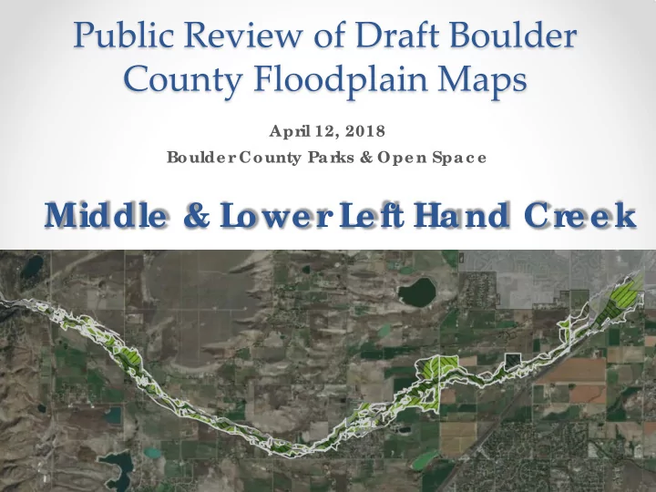
Middle & L
- we r
Public Review of Draft Boulder County Floodplain Maps Apr il 12, - - PowerPoint PPT Presentation
Public Review of Draft Boulder County Floodplain Maps Apr il 12, 2018 Boulde r County Par ks & Ope n Spac e Middle & L owe r L e ft Hand Cr e e k HOUSEKEEPING Sign- in she e t Ne wsle tte r s & F lye r s
Apr il 12, 2018 Boulde r County Par ks & Ope n Spac e
rin Coope r, Boulde r County
COM (CWCB)
rin Ma y, F E MA
Why is this study be ing c onduc te d?
loodpla in de line a tions a re ofte n outda te d
E MA, Sta te s, Communitie s
he Sta te of CO initia te d CHAMP a fte r the F lood of 2013
Why doe s it impac t you?
lood Insura nc e Ra te Ma ps tha t impa c t insura nc e ra te s (ba se d
Whe r e will the r e be c hange s?
www.c olor adohazar dmapping.c om
www.c olor adohazar dmapping.c om
What happe ns ne xt?
he re a re still multiple re vie ws tha t will oc c ur, so da ta is subje c t to c ha ng e
form
his is a first look for you to g e t your input we ll in a dva nc e of da ta fina liza tion
Whe n will c hange s go into e ffe c t?
E MA will re vie w da ta in spring / summe r 2018
lood insura nc e Ra te Ma ps la te 2018/ e a rly 2019
a ppe a l ma ps with te c hnic a l da ta
Upda te d vs. E ffe c tive Disc ha rg e s of the 100- yr F lood E ve nt
L e ft Hand Cr e e k (@ Ho ve r Rd)
ffe c tive F E MA – 4,610 c fs
L e ft Hand Cr e e k (@ Hwy 119)
ffe c tive F E MA – 4,610 c fs
L e ft Hand Cr e e k (@ N 73rd St)
ffe c tive F E MA – 6,330 c fs
L e ft Hand Cr e e k(@ N 63rd St)
ffe c tive F E MA – 6,330 c fs
L e ft Hand Cr e e k (@ Hwy 36)
ffe c tive F E MA – 6,700 c fs
E stimate d Pe ak Disc har ge s E xpe r ie nc e d in 2013 F lood
L e ft Hand Cr e e k (@ Hwy 119)
8,700 c fs (100-500 yr e ve nt)
L e ft Hand Cr e e k (@ N 63rd St)
7,000 c fs (100-500 yr e ve nt)
L e ft Hand Cr e e k (@ Old Sta g e Rd)
3,520 c fs (50-100 yr e ve nt)
r e nt maps fr
in mode l de ve lopme nt
e data available
1981 study: CHAMP:
What’s not in the maps?
CDOT Hwy 36 bridge
F e de r al Role (F E MA)
lood Risk Mapping
lood Risk Manage me nt
lood Insur anc e – available to anyone in Boulde r County
State Role (CWCB)
lood Risk Mapping
L
County)
lood r isk mapping par tic ipation
Ultimate Go al – Pr
ife , He alth, & Safe ty
Now Boulde r County is r e vie wing the CHAMP hydr aulic s and floodplain mapping Summe r 2018
E MA will r e vie w the CHAMP hydr aulic s and floodplain mapping
County to adopt CHAMP floodplain as “be st available data” E ar ly 2019 CHAMP Pr e liminar y F lood Insur anc e Rate Maps issue d 2019 F E MA Appe als Pe r iod for CHAMP mapping 2021 F E MA F lood Insur anc e Rate Maps be c ome e ffe c tive all date s sub je c t to c hang e
Early 2018 Mid 2018 Late 2018 Early 2019 2019 2021+
Hatc he d laye r s ar e same laye r type s as online ; pr inte d in c olor for e ase of vie wing Blue = F loodway Gr e e n = F lood F r inge Or ange = 500- ye ar F loodplain
Solid c olor ar e as =
c urre nt re g ula to ry flo o dpla ins
L e tte r s = Ma p Zo ne s
http:/ / BoCoF loodpla inRe ma pping .c om
What we ’d like to le ar n fr
r e vie w:
Comme nts!
DE ADL INE for c omme nts for this ar e a: MAY 6th
Re ma pping Point of Conta c t: E rin Coope r floodpla inma psc omme nt@boulde rc ounty.org