
SLIDE 1
Public Review of Draft Boulder County Floodplain Maps
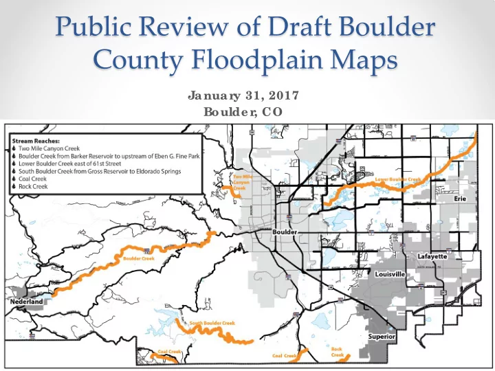
Januar y 31, 2017 Boulde r , CO
Public Review of Draft Boulder County Floodplain Maps Januar y 31, - - PowerPoint PPT Presentation
Public Review of Draft Boulder County Floodplain Maps Januar y 31, 2017 Boulde r , CO HOUSEKEEPING Sign- in she e t Ne wsle tte r s & F lye r s L oc ator Map (add your dot!) Snac ks, r e str ooms, e tc .
Januar y 31, 2017 Boulde r , CO
rin Coope r, Boulde r County
lliott, CWCB
COM (CWCB)
c omme nt be fore the F E MA a ppe a l pe riod
Why is this study be ing c onduc te d?
loodpla in de line a tions a re ofte n outda te d a nd inc orre c t
E MA, Sta te s, Communitie s
he Sta te of CO initia te d CHAMP a fte r the F lood of 2013
Why doe s it impac t you?
lood Insura nc e Ra te Ma ps tha t impa c t insura nc e ra te s (ba se d
Whe r e will the r e be c hange s?
www.c olor adohazar dmapping.c om
www.c olor adohazar dmapping.c om
www.c olor adohazar dmapping.c om
What happe ns ne xt?
he re a re still multiple re vie ws tha t will oc c ur, so da ta is subje c t to c ha ng e
form
his is a first look for you to g e t your input we ll in a dva nc e of da ta fina liza tion
Whe n will c hange s go into e ffe c t?
E MA will re vie w da ta in spring 2017
lood insura nc e Ra te Ma ps in fa ll 2017
a ppe a l ma ps with te c hnic a l da ta
2018/ e a rly 2019
nc our age c ommunity input to impr
ac c ur ac y
ar ly adoption to pr
e side nts
De stro ye d struc ture a lo ng the Middle St. Vra in
Mode le d Disc har ge s of the 100- yr F lood E ve nt
Boulde r Cr e e k (@ Hwy 287)
e ase )
ffe c tive F E MA – 12,700 c fs
Boulde r Cr e e k (b e lo w F
e ase )
ffe c tive F E MA – 11,650 c fs
South Boulde r Cr e e k (a b o ve
E ldo ra do Spring s)
ffe c tive F E MA – NA
E stimate d Pe ak Disc har ge s E xpe r ie nc e d in 2013 F lood
Boulde r Cr e e k (@ Hwy 287)
9,000 c fs (~50 yr e ve nt)
Boulde r Cr e e k (b e lo w F
4,818 c fs (~50 yr e ve nt)
South Boulde r Cr e e k (a b o ve
E ldo ra do Spring s)
2,120 c fs (<25 yr e ve nt)
Mode le d Disc har ge s of the 100- yr F lood E ve nt
T wo Mile Canyon Cr e e k (@ L
inde n a nd 4th St)
e ase )
ffe c tive F E MA – 699 c fs
Coal Cr e e k (@ Hwy 93)
ffe c tive F E MA – NA
Roc k Cr e e k(@ Hwy 128)
ffe c tive F E MA – NA
E stimate d Pe ak Disc har ge s E xpe r ie nc e d in 2013 F lood
Coal Cr e e k (ne a r Pla invie w Rd)
3,900 c fs (> 100 yr e ve nt)
F e de r al Role (F E MA)
lood Risk Mapping
lood Risk Manage me nt
lood Insur anc e – available to anyone
State Role (CWCB)
lood Risk Mapping
L
County)
lood r isk mapping par tic ipation
Ultimate Go al – Pr
ife , He alth, & Safe ty
Now Boulde r County is r e vie wing the hydr aulic s and floodplain mapping Spr ing 2017 F E MA will r e vie w the hydr aulic s and floodplain mapping, Boulde r County to adopt floodplain as “be st available data” L ate 2017 Pr e liminar y F lood Insur anc e Rate Maps issue d E ar ly 2019 F lood Insur anc e Rate Maps E ffe c tive *a ll da te s sub je c t to c ha ng e
c
c
500- ye ar floodplain 100- ye ar floodplain floodway
Some maps on your table s have dr aft laye r s in c olor s (not gr ay)
Hatc he d laye r s ar e same laye r type s as
inte d in c olor for e ase of vie wing
Solid c olor ar e as =
c urre nt re g ula to ry flo o dpla ins
L e tte r s = Ma p Zo ne s
http:/ / boc ofloodpla inre ma pping .c om
Dire c t link: http:/ / a rc g .is/ 2fF 4CZY
e xt b o x with a lte rna tive me tho d
Website
e xt b o x with a lte rna tive me tho d
Website
e xt b o x with a lte rna tive me tho d
Website
e xt b o x with a lte rna tive me tho d
Website
Uppe r r ight hand c or ne r
uc tur e loc ations – ac c ur ate ?
k?
aphic de tails
flow
ms
e vision, te ll us WHY
ADL INE for c omme nts for this ar e a: F E BRUARY 28th
Re ma pping Point of Conta c t: E rin Coope r floodpla inma psc omme nt@boulde rc ounty.org