
SLIDE 1
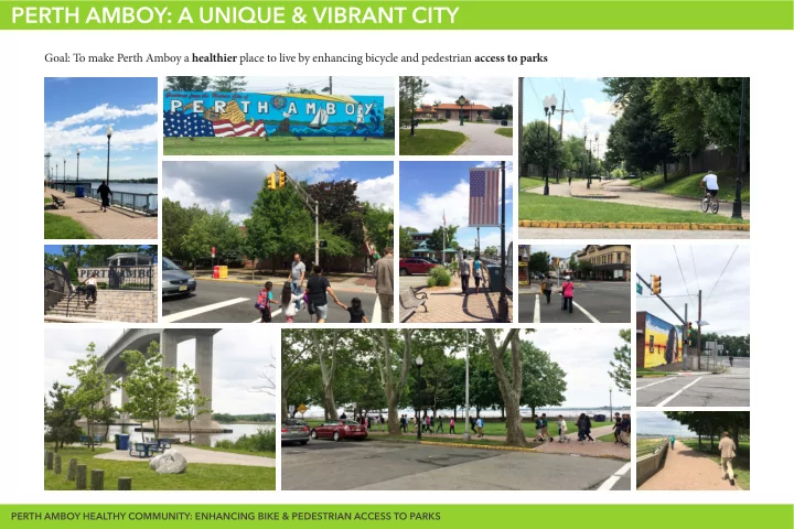
PERTH AMBOY: A UNIQUE & VIBRANT CITY
Goal: To make Perth Amboy a healthier place to live by enhancing bicycle and pedestrian access to parks
PERTH AMBOY HEALTHY COMMUNITY: ENHANCING BIKE & PEDESTRIAN ACCESS TO PARKS
PERTH AMBOY: A UNIQUE & VIBRANT CITY Goal: To make Perth Amboy a - - PowerPoint PPT Presentation
PERTH AMBOY: A UNIQUE & VIBRANT CITY Goal: To make Perth Amboy a healthier place to live by enhancing bicycle and pedestrian access to parks PERTH AMBOY HEALTHY COMMUNITY: ENHANCING BIKE & PEDESTRIAN ACCESS TO PARKS ASSESSING EXISTING
PERTH AMBOY HEALTHY COMMUNITY: ENHANCING BIKE & PEDESTRIAN ACCESS TO PARKS
´
Perth Amboy BLUEPRINT FOR ACTION
Making Perth Amboy a great place to live, learn, work and play! 1C P A B P P
JANUARY 2016
City of Perth Amboy, Middlesex County, New Jersey Master Plan Recreation Element
State of New Jersey Department of Community Affairs Local Planning Services PREPARED FOR THE CITY OF PERTH AMBOY PLANNING BOARD September 2013 101 South Broad Street Phone: 609-292-3000 Trenton, NJ 08625Data collection menu developed to align with NJDEP Complete Streets guidelines for potential future funding
Infrastructure that Supports Walking Infrastructure that Supports Biking Safe Crossings Opportunities for More Open Space
network
Existing bike/pedestrian infrastructure in relation to existing open space and proposed transportation
Proposed Circulation Network
!^
! ! ! ! ! ! !^
! ! !^
!Æ b
! ! ! ! ! ! ! ! ! ! ! ! ! !! ! ! ! ! ! ! ! ! ! ! ! ! ! ! ! ! ! ! !^
!^
! ! ! ! ! ! ! ! ! ! ! ! ! ! ! ! ! ! ! ! ! ! ! ! ! ! ! ! ! ! ! ! ! ! ! ! ! ! ! ! !! ! ! ! ! ! ! ! ! ! ! ! ! ! ! ! !! ! ! ! ! ! ! ! ! ! !! ! ! ! ! ! ! ! ! ! !! ! ! ! !! ! ! ! ! !! ! !! !^
Bike Racks
Path Type Pedestrain Walk !Benches Project
Bike Lane Shared Lane Markings Existing Shared Use PathOpen Space
Shared Path UseRail
Options for Bike Lane or Shared Lane Markings Sidepath 0.175 0.35 0.7 MilesExisting Plan Areas
William Warren Park Truxton Park2
State Str Willow Pond ! Park P f e i f f Francis Street Park e r B l v d Route 4403
y Blvd1
Rudyk Park er e Con v v A y Ambo Waters Stadium Route 440 Brace^
! Ave eet Bike and Pedestrain Trail Washington Park High Str Hall Ave New Bruns4
wick Ave Washington Street Dufy Park Patton enter Park Neal J Lucey Park ! ! ! ! ! F a y e t t e S t r e e t Smith Street ! M a r k5 ^
! ! ! e t S t r ! e e t^ b Æ
! ! ! ! ! ! ! ! ! ! ! ! ! ! ! ! ! ! e e t ! ity Hall Square^
!^
! ! ! ! ! ! ! ! ! ! ! ! ! ! e e t ! ! ! ! ! ! ! ! ! ! ! ! ! a t e r S t r ! ! ! Harborside ! ! ! ! ! ! Waterfront Park ! ! ! W ! ! ! ! ! ! ! ! 2nd Street Park ! ! ! aledonia and Roessle! r !Parl ! ! ! ! S wsk er !! ! ! ! ado i Wat front Park ! ! ! ! ! ! ! ! ! ! ! ! ! ! ! ! ! ! ! ! ! ! ! ! ! !!! ! ! ! ! !^
Bike Racks Path Type Pedestrain Walk Open Space Potential Benches Project Bike Lane High Potential for Open Space ! Shared Lane Markings Rail Existing Shared Use Path Medium Potential for Open Space Shared Path Use´
Open Space Options for Bike Lane or Shared Lane Markings Low Potential for Open Space Sidepath 0.175 0.35 0.7 MilesStreet & Sidewalk Maintenance
d . ! a r ve Rd l . G o F ori ! ! . Maurer Rd ! . . ! . . ! ! ! . ve A . ! y ! .Legend
n ve S rvi a t t e r S w id e e . ! D h ! . d . ! S a . ! r e tCirculation Plan
. ! ! . lvd M S t M n a . ! rke a t B tP
ery r SATH TYPE
G v n´
Future Open Space Perth _Amboy _OutlinePotential Open Space
F i d a G rLegend
Open Space Potential
High Potential for Open Space Medium Potential for Open Space 0.175 0.35 0.7 Miles Low Potential for Open Space´
Open Space Future Open Space Credit: Groundswell Design Group
W O O D B R I D G E E G D I R B D O O W
5 3 E T R E V A H N Y O A L E L B A W V E B R M U A N S W I C K A V E W A S H I N G T O N S T T S H G I H
Centr Business al District
NE W YORK SOUTH R A AMBOY R I T A N R I V E R
D R E V O R G A D I R O L F
City Hall Square Harborside Waterfront Park Caledonia and Roessler Park Tennis Courts Sadowski Waterfront Park 2nd Street Park Neal J Lucy Park Seaman Street Playground YMCA Train Station Basketball Courts Bike and Pedestrian Trail Waters Stadium Rudyk Park Francis Street Park Willow Pond Park Dalton Field Columbus Circle Park Washington Park Park Patton Center Park Riverview Drive Bike and Pedestrian Trail Truxton Park William Warren Park et ee re t S d n 2n 2 u y y
T
y y al a
F L O O O R I D D D A
n t T
A
gton ing h Was n un F i Health Connectors Existing Activity Zones Waterway Connectors Opportunity Zones Potential Rail Greenway Existing Schools Proposed New High School Health Connectors –major city connections for active bike and Potentail Rail Line Greenway pedestrian usage Activity Zones–areas with high activity and recreational potential Existing Schools Waterway Connectors–access to water activities such as canoeing, Proposed New High School kayaking, boating, and fshing Focus Zones–areas highlighted for improved connection ideas
Street and Sidewalk Enhancements
Bike lanes and signage where appropriate
(crosswalk striping, accessible ramps, sidewalk repairs, etc.)
Linking Streets and Parks
Permeable, engaging park edges to pull visitors Easy connections between activity nodes Obvious access points for parks Clear signage for healthy street connectors
H I G H S T H A L L A V E A M B O Y A V E To Woodbridge Rudyk Park Bike and Pedestrain Trail Waters Stadium Francis Street Park Basketball Courts Ashley St Thomas St Alpine St Jacques St Myrtle StCelebrate Park Entrances
More visible park entrances to encourage visitors in (signage, colorful visual cues, etc.)
existing “desire paths”– informal worn paths created by repeated foot or bike traffic
To Amboy Ave TNew Pocket Parks
Small green oases that increase City open space, particularly in underserved areas
dense urban hardscapes
WASHINGT Neal J ON ST Lucy Park N E W B R U N S W I C K A V E B a r r a c k s S t c Madison A e v Commer e St t S e t a t S S m i t h J e S fg t e r sPotential Pocket Park Location – Parcels identifed in the brownfelds survey that appear vacant or underutilized
PERTH AMBOY HEALTHY COMMUNITY: ENHANCING BIKE & PEDESTRIAN ACCESS TO PARKS