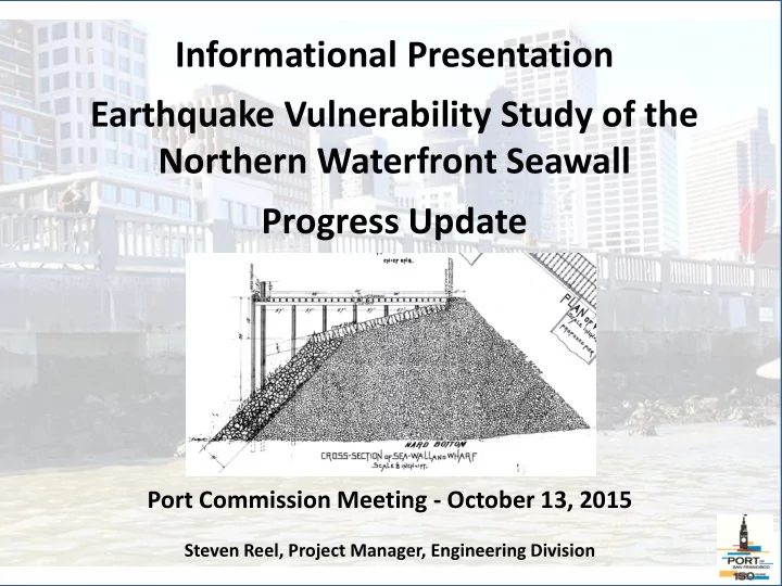
SLIDE 1
Informational Presentation Earthquake Vulnerability Study of the Northern Waterfront Seawall Progress Update
Port Commission Meeting - October 13, 2015
Steven Reel, Project Manager, Engineering Division
SLIDE 2
1850s San Francisco near downtown
SLIDE 3 Great Seawall 1878 - 1915
- Planned in 1870, constructed 1878 to 1915
- Four Miles Long, Located hundreds
- f feet Bayward of Shoreline
- Created 700+ acres of new land.
SLIDE 4
160 Years Later
PIER 45 PIER 50
SLIDE 5 PROMENADE
Design & Construction
Choose elevation that has worked well, approximately 8- 1/2 feet above Mean Sea Level and 3 feet above the Highest Recorded Tide
SLIDE 6
Section 11 Design - October 15, 1909
SLIDE 7
Section 11 Construction – June 8, 1910
SLIDE 8
Section 11 - Today
SLIDE 9
22 Historic Seawall Sections – 1924 Map B, A, 1, 2, 3, 4, 5, 6, 7, 8a, 8b, 8, 9a, 9b, 9, 10, 11a, 11, 12, 13, 46, 48 55 Combinations of Bulkheads and Wharves
SLIDE 10
Vulnerability Study Contract Information Prime Consultant - GHD/GTC Joint Venture GHD – Multinational Firm, SF Office GTC – SF LBE Geotechnical Firm 25% LBE Subconsultant Participation Goal $425,000 Contract Target Completion early 2016
SLIDE 11
Vulnerability Study Contract Scope High Level Screening Approach based on Available Information Phase 1: Comprehensive Information Review and Evaluation (COMPLETE) Phase 2: Vulnerability Analysis (UNDERWAY) Phase 3: Mitigation Alternatives and Recommendations (UNDERWAY) Peer Review by Separate Contract (PENDING)
SLIDE 12 Vulnerability Study Contract Scope
- Establish Zone of Influence
- Develop detailed subsurface maps &
profiles
- Generate site specific earthquake hazard
ground shaking data
- Analyze rock dike for stability and upland
areas for lateral spreading and settlement
- Structural analysis of select bulkhead walls
and wharves
SLIDE 13 Vulnerability Study Contract Scope
- Map utilities and assess impacts
- Assess post earthquake flood hazards
- High level economic impact analysis
- Develop conceptual level mitigation
measures
- Rank and prioritize areas for mitigation
and/or detailed investigation
SLIDE 14
Zone of Influence – Study Boundary
SLIDE 15
Subsurface Mapping – Artificial Fill Thickness
SLIDE 16
Subsurface Mapping – Artificial Fill Thickness
SLIDE 17
Subsurface Mapping – Young Bay Mud Thickness
SLIDE 18
Subsurface Mapping – Young Bay Mud Thickness
SLIDE 19
Subsurface Mapping – Bedrock Elevation
SLIDE 20
Subsurface Mapping – Bedrock Elevation
SLIDE 21
Representative Sections Section B - Vicinity of Pier 43
SLIDE 22
Representative Sections Section 1 - Vicinity of Pier 39
SLIDE 23
Representative Sections Section 3 - Vicinity of Pier 29
SLIDE 24
Representative Sections Section 7 - Vicinity of Pier 3
SLIDE 25
Representative Sections Section 8b - Vicinity of Ferry Building
SLIDE 26
Representative Sections Section 9a – Vicinity of Howard St.
SLIDE 27
Representative Sections Section 12 – Vicinity of Pier 38
SLIDE 28
Representative Sections Section 46 – Vicinity of AT&T Park
SLIDE 29
Structural Sections Bulkhead Wall & Wharf – Pier 9 Area
SLIDE 30
Structural Sections Bulkhead Wall & Wharf – Pier 17 Area
SLIDE 31
Structural Sections Bulkhead Wall & Wharf – Pier 26 – 28 Area
SLIDE 32
Structural Sections Bulkhead Wall & Wharf – Pier 38 Area
SLIDE 33
USGS WORKING GROUP ON CALIFORNIA EARTHQUAKE PROBABILITIES 2014 UPDATE 72% PROBABILITY OF MAJOR EARTHQUAKE BY 2044
SLIDE 34
1906 vs 1989 Loma Prieta Earthquake Ground shaking recorded in Germany
SLIDE 35
SLIDE 36 Next Steps
- Complete Initial Draft of Vulnerability
Results, end of 2015
- Peer Review, end of 2015
- Final Draft of Results & Recommendations
early 2016
- Inform efforts to improve resiliency,
Waterfront Land Use Plan Update, and Climate Change Planning
SLIDE 37
QUESTIONS