geonode david kennewell hydrata com
play

Geonode David.Kennewell@Hydrata.com Geonode Summit 2018 Turino, - PowerPoint PPT Presentation

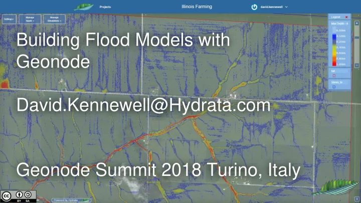
Building Flood Models with Geonode David.Kennewell@Hydrata.com Geonode Summit 2018 Turino, Italy The ANUGA finite volume numerical model ANUGA is open-source software for the simulation of the shallow water equation. Open source


  1. Building Flood Models with Geonode David.Kennewell@Hydrata.com Geonode Summit 2018 Turino, Italy

  2. The ANUGA finite volume numerical model ● ANUGA is open-source software for the simulation of the shallow water equation. ● Open source development is led by the Australian National University and Geoscience Australia. ● Used to analyse flood, tsunami, dam-break, bridge design, river restoration, erosion management… ● Written in Python (most) and C (computational components) https://github.com/GeoscienceAustralia/anuga_core

  3. Traditional Flood Study Online Flood Study vs ● Stored on a specialist’s hard -drive. ● Stored in Geonode. ● Hard to update. ● Update online. ● Hard to manage change. ● Can track change. ● Expensive licensing can restrict ● Open source model licensing stakeholder access for scenario allows for accessible scenario testing testing and collaboration.

  4. Interactive demo: https://hydrata.com/anuga Training video: https://youtu.be/Xztwz3sEDvs GitHub: https://github.com/Hydrata

  5. How does it work?

  6. “Vanilla” Geonode Geonode/ Maploom Geonode Rest Api Django ORM Anugabase User Interface django app postgres Anuganode GSConfig compute machines Geonode_data Geoserver postgis GSConfig Amazon S3 Anugabase django app

  7. Some lessons learned ● Commit to a cloud vendor, but no too much (for example, use IaaS, not Paas) ● Always script the server build process (for example: vagrant, shell scripts and ansible) ● The most effective way to namespace data in this case is to prepend identifiers onto any data filenames when they are uploaded or created: merewether_dem_myfreeformLayerNameHere.shp Project id Data type id Description 10 chars 3 chars the rest These datasets can then be filtered/classified/secured by the UI or APIs as required, anywhere in the app.

  8. Please do get in touch. It would be great to: • Partner on a project together • Collaborate on Geonode development • Set you up with a free trial for hydrata.com • Receive feedback (bonus points for this!) david.kennewell@hydrata.com

Download Presentation
Download Policy: The content available on the website is offered to you 'AS IS' for your personal information and use only. It cannot be commercialized, licensed, or distributed on other websites without prior consent from the author. To download a presentation, simply click this link. If you encounter any difficulties during the download process, it's possible that the publisher has removed the file from their server.

Recommend


More recommend