SLIDE 1
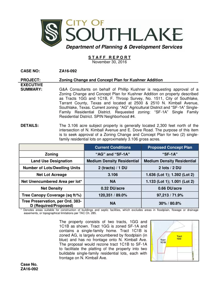
Case No. ZA16-092 S T A F F R E P O R T November 30, 2016 CASE NO: ZA16-092 PROJECT: Zoning Change and Concept Plan for Kushner Addition EXECUTIVE SUMMARY: G&A Consultants on behalf of Phillip Kushner is requesting approval of a Zoning Change and Concept Plan for Kushner Addition on property described as Tracts 1GG and 1C1B, F. Throop Survey, No. 1511, City of Southlake, Tarrant County, Texas and located at 2500 & 2510 N. Kimball Avenue, Southlake, Texas. Current zoning: “AG” Agricultural District and “SF-1A” Single- Family Residential District. Requested zoning: “SF-1A” Single Family Residential District. SPIN Neighborhood #4. DETAILS: The 3.106 acre subject property is generally located 2,300 feet north of the intersection of N. Kimball Avenue and E. Dove Road. The purpose of this item is to seek approval of a Zoning Change and Concept Plan for two (2) single- family residential lots on approximately 3.106 gross acres.
* Denotes areas suitable for construction of buildings and septic facilities, which excludes areas in floodplain, flowage or drainage easements, or topographical limitations per TAC Ch. 285.
The property consists of two tracts, 1GG and 1C1B as shown. Tract 1GG is zoned SF-1A and contains a single-family home. Tract 1C1B is zoned AG, is largely encumbered by floodplain (in blue) and has no frontage onto N. Kimball Ave. The proposal would rezone tract 1C1B to SF-1A to facilitate the platting of the property into two buildable single-family residential lots, each with frontage on N. Kimball Ave. Current Conditions Proposed Concept Plan Zoning “AG” and “SF-1A” “SF-1A” Land Use Designation Medium Density Residential Medium Density Residential Number of Lots/Dwelling Units 2 (tracts) / 1 DU 2 lots / 2 DU Net Lot Acreage 3.106 1.636 (Lot 1); 1.392 (Lot 2) Net Unencumbered Area per lot* NA 1.133 (Lot 1); 1.001 (Lot 2) Net Density 0.32 DU/acre 0.66 DU/acre Tree Canopy Coverage (sq ft/%) 120,351 / 89.0% 97,213 / 71.9% Tree Preservation, per Ord. 383- D (Required/Proposed) NA 30% / 80.8%
Department of Planning & Development Services
SLIDE 2
Case No. ZA16-092 VARIANCE REQUESTED: ACTION NEEDED: Consider 1st Reading Approval of Zoning Change and Concept Plan ATTACHMENTS: (A) Background Information (B) Vicinity Map (C) Concept Plan Review Summary No. 3, dated November 30, 2016 (D) Surrounding Property Owners Map (E) Ordinance No. 480-722 Full Size Plans (for Council members only) Link to PowerPoint Presentation Link to Project Narrative and Variance Request Link to Plans Page 1 - Concept Plan Page 2 - Drainage and Utility Plan Page 3 - Tree Conservation Analysis Link to OSSF Assessment Link to Surrounding Property Owner Responses STAFF CONTACT: Ken Baker (817) 748-8067 David Jones (817) 748-8070
Current Regulation Request
Subdivision Ordinance No. 483, as amended, Section 8.01D, states that all side lot lines shall be perpendicular to the right of way lines or radial in the case of a cul-de-sac or curvilinear design. The proposed lots do not meet the requirement for perpendicular lot lines. Applicant requests a variance with approval of the Concept Plan to allow lot lines as shown.
SLIDE 3 Case No. Attachment A ZA16-092 Page 1 BACKGROUND INFORMATION OWNER: David Meers III APPLICANT: G&A Consultants on behalf of Phillip Kushner PROPERTY SITUATION: Generally located 2,300 feet north of the intersection of N Kimball Avenue and E Dove Road and addressed as 2500 & 2510 N Kimball Avenue. LEGAL DESCRIPTION: Tracts 1GG and 1C1B, F. Throop Survey, No. 1511, City of Southlake, Tarrant County, Texas, approximately 3.106 acres. LAND USE CATEGORY: Medium Density Residential CURRENT ZONING: “AG” Agricultural District and “SF-1A” Single-Family Residential District PROPOSED ZONING: “SF-1A” Single-Family Residential District HISTORY:
- The property was annexed into the Town of Southlake in 1957 as “AG”
(Ord. No. 082).
- A permit was issued in December 1983 to construct a 2,500 square
foot single-family residence on the property.
- A permit was issued in December 1983 to construct a 1,450 square
foot accessory building on the property.
- A permit was issued in April 1984 to construct a septic system on the
property.
- "SF-1A" Single-Family Residential District zoning was placed on Tract
1GG with approval of Zoning Ordinance No. 480 in September 1989. SOUTHLAKE 2030 PLAN: Future Land Use Plan The 2030 future land use designation for the site is Medium Density Residential and Floodplain which are defined in the Southlake 2030 plan as follows: MEDIUM DENSITY RESIDENTIAL Purpose: The purpose of the Medium Density Residential land use category (shown in
- range on the adjacent map) is
to promote a neighborhood setting primarily comprised of single family detached houses.
SLIDE 4 Case No. Attachment A ZA16-092 Page 2 Definition: The Medium Density Residential category is suitable for any single-family detached residential development. Other suitable activities are those permitted in the Public Parks/Open Space and Public/Semi-Public categories previously discussed. FLOODPLAIN Purpose and Definition: The Floodplain category (green on the page 3 map) illustrates areas designated by the August 1995 Federal Emergency Management Agency (FEMA) maps as being in the 100-year floodplain. The “floodplain” is an expanse of natural vegetation and wildlife, and should be preserved as natural open
- area. Within the floodplain is “floodway” that must be kept free of
encroachment in order that the 100-year flood may be carried without harmful increases in the height of flood waters. Although it is not to be encouraged, the portion of the floodplain not in the floodway may be reclaimed for development under certain circumstances if in accordance with FEMA regulations. The designated land use for areas of reclaimed floodplain is that of the immediately adjacent land use category. This designation may also include environmentally sensitive areas, habitats, or wetlands that may not be in FEMA identified floodplains. Pathways Master Plan & Sidewalk Plan The Master Pathways Plan shows a future <8 foot sidewalk along N. Kimball Ave. A minimum 4’ wide sidewalk is required per the Subdivision
- Ordinance. There is currently no sidewalk along the west side of Kimball
Ave north of Dove Rd. The Concept Plan shows a 5’ pedestrian access easement along the frontage of the property. Construction of the sidewalk is required prior to certificate of occupancy. TRANSPORTATION ASSESSMENT: Area Road Network and Conditions Both proposed lots have direct access to N Kimball Ave., a C2U collector with a minimum 70’ of right of way. The applicant has shown a 14.5 foot right of way dedication along the N. Kimball Ave. frontage. TREE PRESERVATION: The applicant has submitted an alternative to a tree survey along with a Tree Conservation Analysis in conformance to Section 7.3.a and Appendix A of the Tree Preservation Ordinance which shows
SLIDE 5 Case No. Attachment A ZA16-092 Page 3 approximately 89% existing tree cover on the site. Tree Preservation Ordinance 585-D requires that 30% of the existing canopy be preserved. The proposed Tree Conservation Analysis shows preservation of approximately 80.8% of existing tree canopy cover. For property sought to be zoned for the Downtown zoning district or a planned development zoning district, including an S-P-1 Site Plan, S-P- 2 Site Plan, Transition, Rural Conservation, Planned Unit Development, or Employment Center zoning district, the City Council shall consider the application for a Conservation Analysis or Plan in conjunction with the corresponding development application. The Planning and Zoning Commission shall review the application and make a recommendation to the City Council regarding the
- application. The City Council shall approve the Plan or Analysis if the
Council finds that the Plan or Analysis provides for the: i. placement of building pads, parking areas, driveways, streets, and utility easements so as to maximize the preservation of environmental features of the property including mature tree stands, natural creeks and ponds, and significant grades; ii. maximizes the preservation of tree cover preservation areas indicated on the Environmental Resource Protection Map; iii. maximizes the preservation of existing tree stands with the potential to buffer residential areas from the noise, glare, and visual effects of nonresidential uses; iv. maximizes the preservation of existing trees, if any, adjoining a natural or man-made drainage creek; v. maximizes the preservation of existing protected trees along rural roadways and other streets as identified and prioritized in the Street Typology designation; and vi. mitigation of altered trees through proposed tree replacement procedures pursuant to this Ordinance. UTILITIES: Water An existing 8” water line along N. Kimball Avenue serves this property. Sewer There is currently no public sewer available at the property. The existing house is served by an On-Site Sewage Facility (OSSF). The applicant is proposing to serve both lots with individual OSSFs. The installation and use of OSSFs is governed by Section 33.14 of the Zoning Ordinance: If the permitted use is not to be immediately served by a sewage collection system connected to an approved community treatment plant or public sewage facility, then such use shall be connected to an approved on-site sewage facility (OSSF) designed and constructed in conformance with the methods and standards approved by the State Department of Health, City’s Plumbing Code, and Ordinance No. 514. Where the use of an OSSF is to be employed, the minimum lot size must be one acre per family, residence or commercial structure, with a minimum usable area of at least one acre, and the use must be approved
SLIDE 6 Case No. Attachment A ZA16-092 Page 4 by the City Council of the City of Southlake. The minimum usable area requirement of one (1) acre per lot shall exclude all areas of the lot:
- a. In any flood plains as identified on the FEMA Flood
Insurance Rate Map;
- b. In any drainage and flowage easements; and
- c. Having topographical limitations as regulated under the
standards for on-site sewage facilities in the Texas Administrative Code Chapter 285. The lot divisions shown in the proposed Concept Plans appear to conform to requirements a, b, and c listed above by providing a minimum of one acre not encumbered by FEMA flood plain areas, drainage easements or topographical limitations as defined in the Texas Administrative Code. An assessment of the property and the proposed plan was performed by a licensed engineer on November 16th which determined each site was suitable for an OSSF. Link to OSSF Assessment CITIZEN INPUT: To date, no SPIN meeting has been held for this item. PLANNING AND ZONING COMMISSION ACTION: November 17, 2016; approved (4-0) subject to Staff Report dated November 11, 2016 and Concept Plan Review Summary No. 2 dated November 11, 2016 specifically granting the variance related to side lot lines and noting the applicant’s willingness to potentially consider some level of mitigation to impervious coverage in terms of sustainable materials. STAFF COMMENTS: Attached is Concept Plan Review Summary No. 3, dated November 30, 2016 Criteria for variance from the Subdivision Ordinance:
- Sec. 9.01 Modifications and Variations:
- A. Compliance: Where the Council finds that compliance with these
regulations would cause unusual hardship or extraordinary difficulties because of exceptional and unique conditions of access, location, shape, size, drainage, or other physical features of the site, the requirements may be modified to mitigate the hardship, provided that the public interest is protected and the development is in keeping with the general spirit and intent of this ordinance.
- 1. This section shall not be interpreted to permit the development of
land which is inherently unsuitable for the use proposed.
- 2. Any modification will not have the effect of preventing the orderly
subdivision of other land in the area in accordance with the provisions of this ordinance.
- B. Discretion of Council: At the discretion of the Council, the normal
SLIDE 7
Case No. Attachment A ZA16-092 Page 5 standards and requirements of this ordinance may also be modified in the case of a Planned Unit Development. Such departures from the standards specified may be made only when the Council finds that the plan provides for convenience and safe access, adequate space for recreation, and provision for light and air, and offers all essential utility services and necessary public and other facilities, and is in conformance with all provisions of the City Code which specifically apply to Planned Unit Development. Surrounding Property Owner Opposition The opposition received from adjacent properties within 200 feet of the proposed zoning change accounts for approximately 11.08% of the surrounding area within the 200 foot boundary. This does not meet the 20% criteria requiring a supermajority vote of Council for approval.
SLIDE 8
Case No. Attachment B ZA16-092 Page 1
SLIDE 9
Case No. Attachment C ZA16-092 Page 1 CONCEPT PLAN REVIEW SUMMARY Case No.: ZA16-092 Review No.: Three Date of Review: 11/30/16 Project Name: Zoning Change and Concept Plan – Kushner Addition, 2500 N Kimball Ave APPLICANT: Randi Rivera OWNER: Phillip Kushner G&A Consultants, LLC P.O. Box 600055 111 Hillside Drive Lewisville, Texas 75057 Dallas, Texas 75360 Phone: 972-436-9712; Fax: 972-436-9715 Phone: 214-991-1905 Email: randi@gacon.com
CITY STAFF HAS REVIEWED THE ABOVE REFERENCED PROJECT RECEIVED BY THE CITY ON 11/29/16 AND OFFERS THE FOLLOWING STIPULATIONS. THESE STIPULATIONS ARE HEREBY MADE CONDITIONS OF ZONING AND CONCEPT PLAN APPROVAL UNLESS SPECIFICALLY AMENDED BY THE CITY COUNCIL. IF YOU HAVE ANY QUESTIONS OR NEED FURTHER CLARIFICATION, PLEASE CONTACT THE APPROPRIATE STAFF MEMBER.
Planning Review David Jones, AICP Principal Planner Phone: (817) 748-8070 Email:djones@ci.southlake.tx.us 1. Per Section 8.01D of Subdivision Ordinance No. 483, as amended, all side lot lines shall be perpendicular to the right of way. A variance must be granted by City Council under the provisions of Section 9.01 in order for the lots to be developed as shown. VARIANCE REQUESTED * Pursuant to comment 1, the 40’ setback line shown on Lot 2 is only required to be 20’ as this area is proposed as a side yard rather than the rear yard. * Prior to issuance of a Certificate of Occupancy of any building, a plat must be approved and filed which complies with the underlying zoning district. * The existing house which sits on Tract 1GG, the accessory structure which sits on Tract 1C1B as well as the encroachment on south line of Tract 1GG shall be removed prior to platting. * Also prior to platting, the existing septic system must be remediated in accordance with Tarrant County Health Department requirements. For questions regarding remediation, contact the Environmental Health Division of Tarrant County Health Department at (817) 321-4960. * Per Section 8.05.A.1, regarding utility lines in new plats or subdivisions, all newly installed electric utility lines and wires that will be operated at nominal voltages, all telephone utility lines and wires, all cable television and other communication or utility lines and wires, and all terminals shall be installed, placed and constructed underground; and cable television, telephone, and electric transformer and primary switching gear may be pad mounted or placed underground. * Per Section 8.05.A.F, all above ground equipment shall be screened from public view, in such a manner that the ground equipment cannot be seen from a public right-of-way. Said screening shall be completed at the time of installation by the utility company and/or developer.
SLIDE 10 Case No. Attachment C ZA16-092 Page 2 _________________________________________________________________________________ Tree Conservation/Landscape Review E-mail: kmartin@ci.southlake.tx.us Keith Martin Landscape Administrator Phone: (817) 748-8229 TREE CONSERVATION COMMENTS: 1. Rename the Tree Conservation Plan to Tree Conservation Analysis. * A Tree Conservation Analysis was submitted with the Concept Plan. There is 89% of existing tree cover on the site and a minimum of 30% of the existing tree cover is required to be
- preserved. The applicant is proposing to remove 19.2% and to preserve 80.8% of the existing
canopy cover on the two lots. A detailed Tree Conservation Plan complying with an approved Tree Conservation Analysis will be required to be submitted with any future plat submittals and/or building construction plans. * Except as provided by subsection 7.2.b. of the Tree Preservation Ordinance, a Tree Conservation Analysis or Tree Conservation Plan shall be approved if it will preserve existing tree cover in accordance with the percentage requirements established by Table 2.0. If the property has previously received a tree permit related to development, the percentage of existing tree cover at the time the first such permit was issued shall be used to calculate the minimum existing tree cover that must be preserved under this section. Table 2.0 – Existing Tree Cover Preservation Requirements Percentage of existing tree cover on the entire site Minimum percentage of the existing tree cover to be preserved* 0% – 20% 70% 20.1 – 40% 60% 40.1% - 60% 50% 60.1% - 80% 40% 80.1% - 100% 30% *The minimum percentage of existing tree cover to be preserved shall exclude any area in public rights-of-way as approved by City Council. * Please be aware that all existing trees shown to be preserved on the City Council approved Tree Conservation Plan must be preserved and protected during all phases and construction
- f the development. Alteration or removal of any of the existing trees shown to be preserved
- n the approved Tree Conservation Plan is a violation of the Tree Preservation Ordinance and
the zoning as approved by the Southlake City Council. Please ensure that the layout of all structures, easements, utilities, structures grading, and any other structure proposed to be constructed do not conflict with existing trees intended to be preserved.
SLIDE 11 Case No. Attachment C ZA16-092 Page 3 * Indicates informational comment. # Indicates required items comment. _________________________________________________________________________________ Community Services Review Peter Kao Construction Manager Phone: 817-748-8607 Email: pkao@ci.southlake.tx.us Park Board comments or recommendations: All applicants are required to appear before the Park Board to discuss park dedication issues if requesting fee payments or fee credits. Please contact the Community Services Department at (817) 748-8607 for further details. Land/park dedication requirements: Residential developments must provide dedicated parks and/or open space at a ratio of one (1) acre
- f park land for every forty (40) dwelling units.
If fee payment is approved by City Council in lieu of land dedication, residential park dedication fees in the amount of $6250 per dwelling unit x 1 additional dwelling unit = $6250. Pathway Comments: New 4ft sidewalk required along Kimball Ave. Should provide pathways consistent with Southlake Master Pathways Plan. Should provide pedestrian access from each building to Trail System or sidewalk connections and between buildings. Should provide 4ft+ concrete sidewalks on both sides
- f all public and private streets consistent with Article V Street and Right-Of-Way Requirements of the
Subdivision Ordinance and all State of Texas accessibility requirements. _________________________________________________________________________________ Public Works/Engineering Review Steven Anderson, P.E. Civil Engineer Phone: (817) 748-8101 E-mail: sanderson@ci.southlake.tx.us GENERAL COMMENTS:
- 1. This review is preliminary. Additional requirements may be necessary with the review of civil
construction plans.
- 2. Any proposed driveways shall comply with the criteria set forth in the driveway ordinance No.
634. INFORMATIONAL COMMENTS:
SLIDE 12 Case No. Attachment C ZA16-092 Page 4 * The proposed OSSF shall comply with TCEQ regulation, US corps of engineers and/or appropriate health departments prior to issuance of building permit. * Sight distances shall comply with AASHTO guidelines on adjacent collectors and arterials. * Sidewalk widths shall conform to the Southlake Pathways Plan. * Use the City of Southlake GPS monuments whenever possible. Monument locations can be found in the City of Southlake website: http://www.cityofsouthlake.com/index.aspx?NID=266 * The size of the water service tap must match the size of the meter. There are no reducers allowed before the meter on the public side. A 1” inch meter must have a 1” tap, etc. * Limits of 100- year floodplain shall be shown and contained within a dedicated drainage easement. * Driveway culvert must be sized by an engineer and submitted for approval to the City Engineer. * Discharge of post development runoff must have no adverse impact on downstream properties and meet the provisions of Ordinance No. 605. * Submit 22”x34” civil construction plans and a completed Construction Plan Checklist directly to the Public Works Administration Department for review. Please allow 15 business days for
- review. The plans shall conform to the most recent construction plan checklist, standard
details and general notes which are located on the City’s website: http://www.cityofsouthlake.com/PublicWorks/engineeringdesign.asp * A right of way permit shall be obtained from the Public Works Operations Department (817) 748-8082 to connect to the City’s sewer, water or storm sewer system. * Any hazardous waste being discharged must be pretreated per Ordinance No. 836. *=Denotes informational comment. _________________________________________________________________________________ Fire Department Review Kelly Clements Fire Marshal Phone: (817) 748-8233 E-mail: kclements@ci.southlake.tx.us
- 1. No comments based on submitted information.
_________________________________________________________________________________ General Informational Comments: * All lighting must comply with the Lighting Ordinance No. 693, as amended.
SLIDE 13
Case No. Attachment C ZA16-092 Page 5 * All development must comply with the Drainage Ordinance No. 605 and the Erosion and Sediment Control Ordinance No. 946, as amended. * Denotes Informational Comment
SLIDE 14 Case No. Attachment D ZA16-092 Page 1 SURROUNDING PROPERTY OWNERS MAP & RESPONSES
SPO # Owner Zoning Physical Address Acreage Response
1. BERRYMAN, JESSE W SF1-A 1701 CREEKSIDE DR 1.195 U 2. DAVIS, JONATHAN A SF1-A 1703 CREEKSIDE DR 1.072 NR 3. DYER, TODD H AG 2058 N KIMBALL AVE 0.492 F 4. DYER, TODD H AG 2052 N KIMBALL AVE 0.646 F 5. LAMBERT, DAVID A AG 2800 N KIMBALL AVE 1.613 O 6. LAMBERT, DAVID A AG 2804 N KIMBALL AVE 1.154 O 7. MEERS, DAVID AG 2510 N KIMBALL AVE 0.983 F 8. MEERS, DAVID SF1-A 2500 N KIMBALL AVE 2.129 F 9. SHIA, PAUL AG 2056 N KIMBALL AVE 1.022 F
SF1-A 1659 CREEKSIDE DR 1.196 NR
Zoning Change Boundary Concept Plan Boundary
SLIDE 15 Case No. Attachment D ZA16-092 Page 2
AG (Army Corps Property) 15.691 NR
AG 2054 N KIMBALL AVE 1.215 NR
AG 2054 N KIMBALL AVE 1.768 NR
- 14. Superintendent of Carroll ISD
NR
- 15. Superintendent of Grapevine
Colleyville ISD NR
- 16. Superintendent of Northwest ISD
NR
- 17. Superintendent of Keller ISD
NR
NR Responses: F: In Favor O: Opposed To U: Undecided NR: No Response Notices Sent: Fourteen (14) Responses Received: Three (3) In Favor; One (1) Opposed; One (1) Undecided Link to Surrounding Property Owner Responses
SLIDE 16 Case No.
ZA16-092 Page 1
CITY OF SOUTHLAKE, TEXAS ORDINANCE NO. 480-722 AN ORDINANCE AMENDING ORDINANCE NO. 480, AS AMENDED, THE COMPREHENSIVE ZONING ORDINANCE OF THE CITY OF SOUTHLAKE, TEXAS; GRANTING A ZONING CHANGE ON A CERTAIN TRACT OR TRACTS OF LAND WITHIN THE CITY OF SOUTHLAKE, TEXAS BEING LEGALLY DESCRIBED AS TRACTS 1GG AND 1C1B, F. THROOP SURVEY, NO. 1511, CITY OF SOUTHLAKE, TARRANT COUNTY, TEXAS, APPROXIMATELY 3.106 ACRES FROM “AG” AGRICULTURAL DISTRICT AND “SF-1A” SINGLE- FAMILY RESIDENTIAL DISTRICT TO “SF-1A” SINGLE-FAMILY RESIDENTIAL DISTRICT AS DEPICTED ON THE APPROVED CONCEPT PLAN ATTACHED HERETO AND INCORPORATED HEREIN AS EXHIBIT “B”, SUBJECT TO THE SPECIFIC REQUIREMENTS CONTAINED IN THIS ORDINANCE; CORRECTING THE OFFICIAL ZONING MAP; PRESERVING ALL OTHER PORTIONS OF THE ZONING ORDINANCE; DETERMINING THAT THE PUBLIC INTEREST, MORALS AND GENERAL WELFARE DEMAND THE ZONING CHANGES AND AMENDMENTS HEREIN MADE; PROVIDING THAT THIS ORDINANCE SHALL BE CUMULATIVE OF ALL ORDINANCES; PROVIDING A SEVERABILITY CLAUSE; PROVIDING FOR A PENALTY FOR VIOLATIONS HEREOF; PROVIDING A SAVINGS CLAUSE; PROVIDING FOR PUBLICATION IN THE OFFICIAL NEWSPAPER; AND PROVIDING AN EFFECTIVE DATE. WHEREAS, the City of Southlake, Texas is a home rule City acting under its Charter adopted by the electorate pursuant to Article XI, Section 5 of the Texas Constitution and Chapter 9 of the Texas Local Government Code; and, WHEREAS, pursuant to Chapter 211 of the Local Government Code, the City has the authority to adopt a comprehensive zoning ordinance and map regulating the location and use of buildings, other structures and land for business, industrial, residential and other purposes, and to amend said ordinance and map for the purpose of promoting the public health, safety, morals and general welfare, all in accordance with a comprehensive plan; and WHEREAS, the hereinafter described property is currently zoned as “AG” Agricultural
SLIDE 17 Case No.
ZA16-092 Page 2
District and “SF-1A” Single-Family Residential District under the City’s Comprehensive Zoning Ordinance; and WHEREAS, a change in the zoning classification of said property was requested by a person or corporation having a proprietary interest in said property; and WHEREAS, the City Council of the City of Southlake, Texas, at a public hearing called by the City Council did consider the following factors in making a determination as to whether these changes should be granted or denied: safety of the motoring public and the pedestrians using the facilities in the area immediately surrounding the sites; safety from fire hazards and damages; noise producing elements and glare of the vehicular and stationary lights and effect of such lights on established character of the neighborhood; location, lighting and types
- f signs and relation of signs to traffic control and adjacent property; street size and
adequacy of width for traffic reasonably expected to be generated by the proposed use around the site and in the immediate neighborhood; adequacy of parking as determined by requirements of this ordinance for off-street parking facilities; location of ingress and egress points for parking and off-street loading spaces, and protection of public health by surfacing
- n all parking areas to control dust; effect on the promotion of health and the general welfare;
effect on light and air; effect on the over-crowding of the land; effect on the concentration of population, and effect on transportation, water, sewerage, schools, parks and other public facilities; and, WHEREAS, the City Council of the City of Southlake, Texas, further considered among other things the character of the districts and their peculiar suitability for particular uses and the view to conserve the value of the buildings, and encourage the most appropriate use of the land throughout this City; and, WHEREAS, the City Council of the City of Southlake, Texas, does find that there is a
SLIDE 18 Case No.
ZA16-092 Page 3
public necessity for the zoning changes, that the public demands them, that the public interest clearly requires the amendments, and that the zoning changes do not unreasonably invade the rights of those who bought or improved property with reference to the classification which existed at the time their original investment was made; and, WHEREAS, the City Council of the City of Southlake, Texas, does find that the changes in zoning lessen the congestion in the streets, helps secure safety from fire, panic, and other dangers, promotes the health and the general welfare, provides adequate light and air, prevents the over-crowding of land, avoids undue concentration of population, and facilitates the adequate provision of transportation, water, sewerage, schools, parks and
- ther public requirements; and,
WHEREAS, the City Council of the City of Southlake, Texas, has determined that there is a necessity and need for the changes in zoning and has also found and determined that there has been a change in the conditions of the property surrounding and in close proximity to the tract or tracts of land requested for a change since the tract or tracts of land were originally classified and therefore feels that the respective changes in zoning classification for the tract or tracts of land are needed, are called for, and are in the best interest of the public at large, the citizens of the city of Southlake, Texas, and helps promote the general health, safety and welfare of the community. NOW, THEREFORE, BE IT ORDAINED BY THE CITY COUNCIL OF THE CITY OF SOUTHLAKE, TEXAS: SECTION 1. That Ordinance No. 480, the Comprehensive Zoning Ordinance of the City of Southlake, Texas, passed on the 19th day of September, 1989, as originally adopted and amended, is hereby amended so that the permitted uses in the hereinafter described areas
SLIDE 19 Case No.
ZA16-092 Page 4
be altered, changed and amended as shown and described below: Being described as Tracts 1GG and 1C1B, F. Throop Survey, No. 1511, City of Southlake, Tarrant County, Texas, being approximately 3.106 acres, and more fully and completely described in Exhibit “A” from “AG” Agricultural District and “SF-1A” Single Family Residential District to “SF-1A” Single Family Residential District as depicted on the approved Concept Plan attached hereto and incorporated herein as Exhibit “B”, and subject to the following conditions: Reserved for Council motion SECTION 2. That the City Manager is hereby directed to correct the Official Zoning map of the City
- f Southlake, Texas, to reflect the herein changes in zoning.
SECTION 3. That in all other respects the use of the tract or tracts of land herein above described shall be subject to all the applicable regulations contained in said Zoning Ordinance and all
- ther applicable and pertinent ordinances for the City of Southlake, Texas. All existing
sections, subsections, paragraphs, sentences, words, phrases and definitions of said Zoning Ordinance are not amended hereby, but remain intact and are hereby ratified, verified, and affirmed. SECTION 4. That the zoning regulations and districts as herein established have been made in accordance with the comprehensive plan for the purpose of promoting the health, safety, morals and the general welfare of the community. They have been designed, with respect to both present conditions and the conditions reasonably anticipated to exist in the foreseeable future; to lessen congestion in the streets; to provide adequate light and air; to prevent over- crowding of land; to avoid undue concentration of population; and to facilitate the adequate provision of transportation, water, sewerage, drainage and surface water, parks and other
SLIDE 20 Case No.
ZA16-092 Page 5
commercial needs and development of the community. They have been made after a full and complete hearing with reasonable consideration among other things of the character of the district and its peculiar suitability for the particular uses and with a view of conserving the value of buildings and encouraging the most appropriate use of land throughout the community. SECTION 5. That this ordinance shall be cumulative of all other ordinances of the City of Southlake, Texas, affecting zoning and shall not repeal any of the provisions of said ordinances except in those instances where provisions of those ordinances are in direct conflict with the provisions of this ordinance. SECTION 6. That the terms and provisions of this ordinance shall be deemed to be severable and that if the validity of the zoning affecting any portion of the tract or tracts of land described herein shall be declared to be invalid, the same shall not affect the validity of the zoning of the balance of said tract or tracts of land described herein. SECTION 7. Any person, firm or corporation who violates, disobeys, omits, neglects or refuses to comply with or who resists the enforcement of any of the provisions of this ordinance shall be fined not more than Two Thousand Dollars ($2,000.00) for each offense. Each day that a violation is permitted to exist shall constitute a separate offense. SECTION 8. All rights and remedies of the City of Southlake are expressly saved as to any and all violations of the provisions of Ordinance No. 480, as amended, or any other ordinances affecting zoning which have accrued at the time of the effective date of this ordinance; and,
SLIDE 21 Case No.
ZA16-092 Page 6
as to such accrued violations and all pending litigation, both civil and criminal, whether pending in court or not, under such ordinances, same shall not be affected by this ordinance but may be prosecuted until final disposition by the courts. SECTION 9. The City Secretary of the City of Southlake is hereby directed to publish the proposed
- rdinance or its caption and penalty together with a notice setting out the time and place for a
public hearing thereon at least fifteen (15) days before the second reading of this ordinance, and if this ordinance provides for the imposition of any penalty, fine or forfeiture for any violation of any of its provisions, then the City Secretary shall additionally publish this
- rdinance in the official City newspaper one time within ten (10) days after passage of this
- rdinance, as required by Section 3.13 of the Charter of the City of Southlake.
SECTION 10. This ordinance shall be in full force and effect from and after its passage and publication as required by law, and it is so ordained. PASSED AND APPROVED on the 1st reading the 6th day of December 2016. ________________________________ MAYOR ATTEST: ________________________________ CITY SECRETARY
SLIDE 22 Case No.
ZA16-092 Page 7
PASSED AND APPROVED on the 2nd reading the 17th day of January 2017. ________________________________ MAYOR ATTEST: ________________________________ CITY SECRETARY APPROVED AS TO FORM AND LEGALITY: _________________________________ CITY ATTORNEY DATE:___________________________ ADOPTED:_______________________ EFFECTIVE:______________________
SLIDE 23 Case No.
ZA16-092 Page 8
EXHIBIT “A”
SLIDE 24 Case No.
ZA16-092 Page 9
EXHIBIT “B” Reserved for City Council approved plans