SLIDE 1
#BlackAndSTEM ...in GIS/Cartography
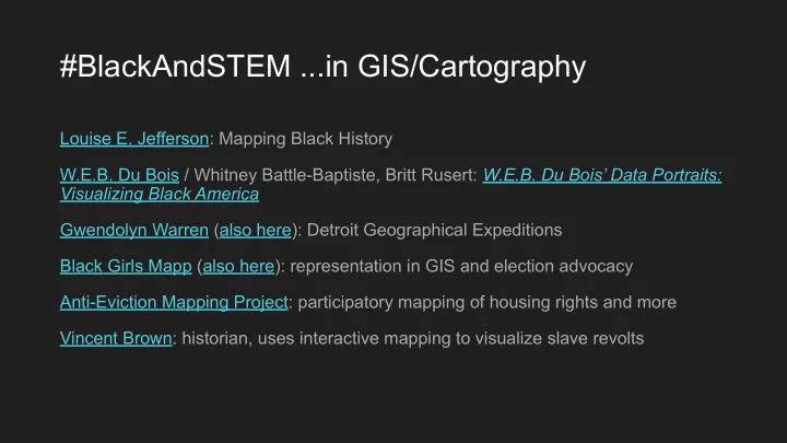
Louise E. Jefferson: Mapping Black History W.E.B. Du Bois / Whitney Battle-Baptiste, Britt Rusert: W.E.B. Du Bois’ Data Portraits: Visualizing Black America Gwendolyn Warren (also here): Detroit Geographical Expeditions Black Girls Mapp (also here): representation in GIS and election advocacy Anti-Eviction Mapping Project: participatory mapping of housing rights and more Vincent Brown: historian, uses interactive mapping to visualize slave revolts
SLIDE 2
Projections, why they matter, and districting
SLIDE 3
- 1. Introduction to projections
- 2. Why projections matter
- 3. Considerations for districting
- 4. Setting projections in QGIS
SLIDE 4 “Visually depicting space and power --- cartography --- is a political act in every sense. Maps represent things not as they are, but as we need or want them to be for particular purposes.
- - Jessica A. Krug, Fugitive Modernities
SLIDE 5
https://www.atlasob scura.com/articles/ mercator-peters-bo ston-map
SLIDE 6
From the Earth to a sphere to a map…
SLIDE 7
Earth to Sphere: Geographic Coordinate System (GCS)
(sometimes aka datum)
SLIDE 8
Geographic coordinates: Latitude and Longitude (parallels and meridians)
SLIDE 9
Examples of lat/long...
Boston: 42.4° N, 71.1° W Oahu, Hawai’i: 21.4° N, 158.0° W Montgomery, Alabama: 32.4° N, 86.3° W ⅓ and ⅔ cuts of New York State: 42° N, 44° N Tufts University: 42.40° N, 71.12° W MGGG’s Redistricting Lab at Tufts University: 42.4079° N, 71.1209° W
SLIDE 10
Thanks, XKCD
SLIDE 11
Sphere to (flat) map: Projected Coordinate Systems (PCS)
aka projections Note: projections include a GCS
SLIDE 12 Projected Coordinate Systems (PCS)
aka projections
Start with a developable surface
- Cylinder
- Cone
- Plane
- (mathematical)
SLIDE 13 All projections distort
https://www.leventhalmap.org/digital-exhibitions/ bending-lines/interactives/projection-face/
SLIDE 14 Projections also can preserve certain properties:
- Conformal: preserves angles (~shapes)
- Equivalent (equal area): preserves areas
- Equidistant: preserves distance to anywhere on
the map ○ …from either one point (planar) ○ …or two points (cylindrical and conic)
- Azimuthal: preserves direction from a single
point (all are planar)
- Compromise: balances shape, area, direction,
and distance
https://www.leventhalmap.org/digital-exhibitions/bending-li nes/interactives/tissots-indicatrix/
SLIDE 15
Winkel Tripel Robinson
Compromise Projections
SLIDE 16
Case: intersection with reference globe
Tangent: rests on top of the reference globe Secant: slices through reference globe Properties preserved at standard lines(s) In QGIS: Lat_1 and Lat_2
SLIDE 17
Aspect: orientation of developable surface to ref. globe
Normal: developable surface oriented parallel to Earth’s axis of rotation Transverse: developable surface oriented 90° from Earth’s axis of rotation Oblique: developable surface is neither normal nor transverse
SLIDE 18 Review
Pay attention to:
- Geographic Coordinate System (GCS)
- Projected Coordinate System (PCS, or “projection”)
○ Includes GCS ○ Centering ■ Standard lines: often lat_1 and lat_2 ■ Longitudinal center for normal case: lon_0
SLIDE 19
Why do projections matter?
SLIDE 20 Why do projections matter? In general...
- Getting your message across:
○ What does the world look like? Mercator versus Peters ○ Should North be up? ○
- Meeting the purpose of your map:
○ Navigation ○ Representing another variable in specific areas (e.g., race using color or dots) ○ Showing how places relate to one another ○
○ Area of specific polygons? ○ Distance between places or from a point? ○
- Equal-area maps: more socially just?
...or maybe they don’t? “[W]e don’t need a new map; we need a new view of the world.” - Peters
SLIDE 21 Why do projections matter? In Districting/MGGG work...
Districtr Mapmaking
Compactness Precinct work: locally appropriate and consistent
SLIDE 22 Projections in QGIS
Coordinate Reference System (CRS):
- Geographic Coordinate System
(GCS)
- Projected Coordinate Systems (PCS,
includes GCS)
SLIDE 23
- Based on libraries used in open-source mapping
○ European Petroleum Search Group (EPSG) ○ Institut Geographic National de France (IGNF) ○ (Environmental Systems Research Institute: ESRI)
- EPSG numbers used as shorthand for projections
○ Can remember name or EPSG number ○ e.g., 3310: Albers Equal Area, Centered on California, using GCS NAD83
Projections in QGIS
SLIDE 24
Some common Geographic Coordinate Systems
Most common: ○ WGS84 (World Geodetic System 1984): EPSG 4326 ○ NAD83 (North American Datum 1983): EPSG 4269
SLIDE 25 Some Common Projections
(Projected Coordinate Systems)
- Albers Equal Area (conic)
- Lambert Conformal Conic (conic)
- Mercator (cylindrical)
○
UTM: Universal Transverse Mercator
○
Web Mercator
- State Plane: locally parameterized for each
state (two per state)
○ Lambert conformal conic ○ Transverse mercator
- Plate Carree (Cylindrical): “unprojected”
SLIDE 26
A note...
If a PCS is not set, QGIS has to guess or set one
○ Default: Plate Carree
SLIDE 27
Projections in QGIS
SLIDE 28 Identifying and Setting a layer’s projection
- Temporary: Layer Properties
→ Geometry and CRS
features as → CRS Note: If you attempt to bring in a layer with a different GCS, QGIS will ask to do a datum transformation to align the layers.
SLIDE 29 Setting a project’s projection
- Automatically set from first layer
added
○ Layer: Set Project CRS from layer ○ Project → Properties → CRS
SLIDE 30 Guidelines
Choose what kind of distortion to minimize:
- Angles/shape
- Area
- Distance
- Direction
- More than one
Choose a projection that is EITHER:
- Locally parameterized, OR
- Generally appropriate and set local (custom) parameters (rare for
QGIS)
SLIDE 31 Clues your projection is “off”
- Known boundaries are at strange angles
○ Your projection isn’t centered on the area of your layer (e.g., a North America projection for Maine)
- When you zoom to a layer, you can’t see the others
○ Could also be an issue of generalization (level of detail)