A Geostationary Microwave Sounder A Geostationary Microwave Sounder - PowerPoint PPT Presentation
National Aeronautics and National Aeronautics and GEOSTAR Space Administration Space Administration Jet Propulsion Laboratory Jet Propulsion Laboratory California Institute of Technology California Institute of Technology Pasadena,
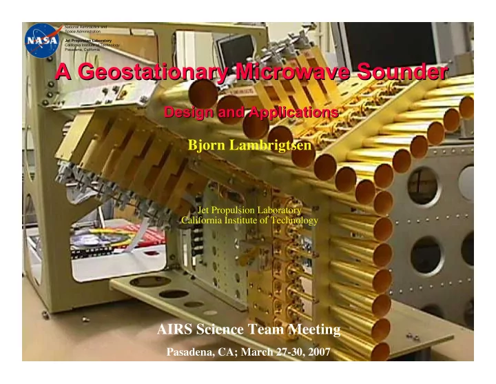
National Aeronautics and National Aeronautics and GEOSTAR Space Administration Space Administration Jet Propulsion Laboratory Jet Propulsion Laboratory California Institute of Technology California Institute of Technology Pasadena, California Pasadena, California A Geostationary Microwave Sounder A Geostationary Microwave Sounder Design and Applications Design and Applications Bjorn Lambrigtsen Jet Propulsion Laboratory California Institute of Technology AIRS Science Team Meeting Pasadena, CA; March 27-30, 2007 AIRS STM, Pasadena, CA — March 30, 2007 Lambrigtsen
National Aeronautics and GEOSTAR Space Administration Jet Propulsion Laboratory California Institute of Technology Pasadena, California Summary • GeoSTAR is a microwave sounder intended for GEO – Ground-based proof-of-concept prototype has been developed • Excellent performance => Breakthrough development! – Space-based version can be developed in time for GOES-R/S (2014-16) • Functionally equivalent to AMSU – Tropospheric T-sounding @ 50 GHz with � 50 km resolution • Stand-alone all-weather temperature soundings • Cloud clearing of IR sounder – Tropospheric q-sounding @ 183 GHz with � 25 km resolution • Stand-alone all-weather water vapor/liquid water soundings • Rain mapping • Tropospheric wind profiles (Only feasible from GEO) • Using Aperture Synthesis – Also called Synthetic Thinned Array Radiometer (STAR) AIRS STM, Pasadena, CA — March 30, 2007 Lambrigtsen
National Aeronautics and GEOSTAR Space Administration Jet Propulsion Laboratory California Institute of Technology Pasadena, California Why? • GEO sounders achieve high temporal resolution – LEO: Global coverage, but poor temporal resolution; high spatial res. is easy – GEO: High temporal resolution and coverage, but only hemispheric non-polar coverage; high spatial res. is difficult – Requires equivalent measurement capabilities as now in LEO: IR & MW • MW sounders measure quantities IR sounders can’t – Meteorologically “interesting” scenes • Full cloud cover; Severe storms & hurricanes – Cloud liquid water distribution – Precipitation & convection • MW sounders complement IR sounders – Complement primary IR sounder (HES) with matching MW sounder • Until now not feasible due to very large aperture required (~ 4-6 m dia. in GEO) – Microwave provides cloud/”cloud-clearing” information • Requires T-sounding through clouds - to surface under all atmospheric conditions • A MW sounder is one of the most desired GEO payloads – High on the list of unmet capabilities AIRS STM, Pasadena, CA — March 30, 2007 Lambrigtsen
National Aeronautics and GEOSTAR Space Administration Jet Propulsion Laboratory California Institute of Technology Pasadena, California NRC Decadal Survey NRC Decadal Survey recommends “PATH” (= GeoSTAR)! AIRS STM, Pasadena, CA — March 30, 2007 Lambrigtsen
National Aeronautics and GEOSTAR Space Administration Jet Propulsion Laboratory California Institute of Technology Pasadena, California Why No MW/GEO Sounder Already? • Difficult to build large enough aperture – AMSU-equivalence requires 6 meter parabolic dish: Difficult to stow and deploy – High surface fidelity required for adequate beam efficiency: Beam efficiency of 95%+ required for sounding – Mesh or film technology not available at sounding frequencies: Must use solid dish • Means large volume, mass, moment of inertia • Difficult to achieve adequate spatial coverage – Dish antenna must be mechanically scanned: Difficult to scan very large dish – Scanning subreflector is problematic: Beam quality/efficiency degrades with scan angle • Therefore, scan range is limited • Difficult to overcome system limitations – Mechanical scanning causes platform disturbances: Cannot coexist with super-high resolution imagers – Large platform resources required: Mass, power, volume, platform control – High risk at system level – Difficult to expand to meet future growing needs AIRS STM, Pasadena, CA — March 30, 2007 Lambrigtsen
National Aeronautics and GEOSTAR Space Administration Jet Propulsion Laboratory California Institute of Technology Pasadena, California Notional Measurement Requirements • Radiometric sensitivity – Must be no worse than AMSU ( � 1 K) • Spatial resolution – At nadir: � 50 km for T; � 25 km for q • Spectral coverage – Tropospheric T-sounding: Must use 50-56 GHz • Note: Higher frequencies (118 GHz, etc.) cannot penetrate to the surface everywhere (e.g., tropics) • Bottom 2 km (PBL) is the most important/difficult part and must be adequately covered – Tropospheric q-sounding: Must use 183 GHz (AMSU-B channels) • Note: Higher frequencies (325 or 450 GHz) cannot penetrate even moderate atmospheres – Convective rain: 183 GHz (AMSU-B channels) method proven – “Warm rain”: 89 + 150 GHz (Grody) - use 50 GHz instead of 89 • Temporal coverage from GEO – T-sounding: Every 30 minutes @ 50 km resolution or better – Q-sounding: Every 30 minutes @ 25 km resolution or better These are strawman performance goals for GeoSTAR #1 (to be improved by x2 next) AIRS STM, Pasadena, CA — March 30, 2007 Lambrigtsen
National Aeronautics and GEOSTAR Space Administration Jet Propulsion Laboratory California Institute of Technology Pasadena, California Applications • Weather forecasting -Improve regional forecasts; severe storms – All-weather soundings - standalone, but also complements IR soundings – Full hemispheric soundings @<50/25 km every ~ 30 minutes (continuous) – “Synoptic” rapid-update soundings => Forecast error detection; 4DVAR applications • Hurricane diagnostics -Quintessential hurricane sensor – Scattering signal from hurricanes/convection easily measurable – Measure location, intensity & vertical structure of convective bursts – Detect intensification/weakening in NRT, frequently sampled (~ 10 minutes) – Measure all three phases of water: vapor, liquid, ice - vertically resolved! • Rain -Complement GPM – Full hemisphere @ � 25 km every 30 minutes (continuous) - both can be improved – Complements GPM/TRMM: fill space-time gaps through “data fusion” methods – Measure snowfall, light rain, intense convective precipitation (per Weng and per Staelin) • Tropospheric wind profiling -NWP, transport applications – Surface to 300 mb; adjustable pressure levels; very high temp.res.; in & below clouds • Climate research -Hydrology cycle, climate variability – Stable & continuous MW observations => Long term trends in T & q and storm stats – Fully resolved diurnal cycle: water vapor, clouds, convection – “Science continuity”: GeoSTAR channels = AMSU channels AIRS STM, Pasadena, CA — March 30, 2007 Lambrigtsen
National Aeronautics and GEOSTAR Space Administration Jet Propulsion Laboratory California Institute of Technology Pasadena, California IR vs. MW AIRS STM, Pasadena, CA — March 30, 2007 Lambrigtsen
National Aeronautics and GEOSTAR Space Administration Jet Propulsion Laboratory California Institute of Technology Pasadena, California IR vs. MW: Pros & Cons • Spatial resolution – IR vs. MW: 10-15 km vs. 15-50 km hor.res.; 1-1.5 km vs. 2-3 km vert.res. • Basic sounding accuracy – IR vs. MW: 1 K vs. 1.5 K for T(z); 15% vs. 20% for q(z); none vs. 40% for L(z) • Scene coverage – Cloud free: IR outperforms MW (but IR = MW in coverage) – Partly cloudy: IR < MW (IR depends on “cloud clearing”, a noise-amplifying process) – Fully cloudy, storms: MW far outperforms IR (“cloud clearing” cannot be done) • Hurricanes & severe storms – IR can only see cloud tops, often obscured by cirrus shields – MW can see to surface (except in heavy precipitation: switch to convection observations) • Summary – IR is best suitable for global observations and storm precursor conditions in clear sky – MW is best suited for observing in/through storms and precursor conditions in clouds AIRS STM, Pasadena, CA — March 30, 2007 Lambrigtsen
National Aeronautics and GEOSTAR Space Administration Jet Propulsion Laboratory California Institute of Technology Pasadena, California IR vs. MW: Coverage - 1 May 16, 2006: Stormy case White: Poor retrievals (“qual” = 2) AIRS IR+MW AIRS cloud-cleared retrievals AIRS Vis/NIR AIRS quality flags • Use with confidence • Use with caution • Do not use AIRS MW AIRS MW-only retrievals GOES soundings AIRS STM, Pasadena, CA — March 30, 2007 Lambrigtsen
National Aeronautics and GEOSTAR Space Administration Jet Propulsion Laboratory California Institute of Technology Pasadena, California IR vs. MW: Coverage - 2 May 20, 2006: Good-weather case Note sun glint area AIRS IR+MW AIRS MW AIRS STM, Pasadena, CA — March 30, 2007 Lambrigtsen
National Aeronautics and GEOSTAR Space Administration Jet Propulsion Laboratory California Institute of Technology Pasadena, California Example MW Soundings Aircraft sounder HAMSR (ATMS prototype) Results from recent NAMMA hurricane field campaign/Cape Verde Water vapor retrievals SAL (dry air layer) AIRS STM, Pasadena, CA — March 30, 2007 Lambrigtsen
National Aeronautics and GEOSTAR Space Administration Jet Propulsion Laboratory California Institute of Technology Pasadena, California Hurricanes Observations with Microwave Sounders AIRS STM, Pasadena, CA — March 30, 2007 Lambrigtsen
Recommend
More recommend
Explore More Topics
Stay informed with curated content and fresh updates.
