A certain company (Ligado) has License for transmitting Satellite to - - PowerPoint PPT Presentation

a certain company ligado has license for transmitting
SMART_READER_LITE
LIVE PREVIEW

A certain company (Ligado) has License for transmitting Satellite to - - PowerPoint PPT Presentation

A certain company (Ligado) has License for transmitting Satellite to Ground for Communications in the very quiet MSS Band very close to the Main GPS frequency But the received power was very low and did not support a large Data Rate 10/22/2019


slide-1
SLIDE 1

Parkinson UAG Presentation Oct. 2019 7

A certain company (Ligado) has License for transmitting Satellite to Ground for Communications in the very quiet MSS Band very close to the Main GPS frequency But the received power was very low and did not support a large Data Rate

10/22/2019

slide-2
SLIDE 2

Convert the License to high power terrestrial transmissions (Asked for 15.8 Kw)

Tower Spacing at about ¼ mile Would support broadband sending movies etc. = 5G? Spectrum Value would jump: $2B $12B+

Tried to get the FCC to slip this through just before Thanksgiving 2010 while everyone was digesting turkey PNT community found out and realized this would do grave harm to GPS civil receivers- We helped slow the process down. Over But*But apparently a predecessor Lxxx company had already known there was a significant Clash

Ligado claimed no knowledge According to Harbinger lawsuit this was not true

Parkinson UAG Presentation Oct. 2019 8 10/22/2019

slide-3
SLIDE 3

Ligado proposal was extensively tested by DOT Ligado now proposes 9.8 watt transmitters. (Company

could receive a windfall profit of over $10B) Unknown, but probably very close tower spacing

Even at this reduced level, at 300m transmitter spacing, over half the High Precision GPS receivers would be degraded over more than 10% of the

  • perating Region, with many degraded over 100% of

the Region (Based on DOT extensive ABC Testing) Many other organizations have filed opposition The PNTAB strongly recommends disapproval of this proposal

9 10/22/2019 Parkinson UAG Presentation Oct. 2019

slide-4
SLIDE 4

Partial List - Green particularly at risk Aviation and Space

Area and Enroute Navigation Approach to Airport Landing to Cat III NextGen & ADS-B UAV Guidance (Drones) Space Launch Guidance

Agriculture

Auto Farming Crop Spraying Precision Cultivating Yield assessment

Robotics and Machine Control

Construction Vehicle Guidance Mining Vehicle Guidance

Scientific

International Time Standard Earth Crustal Movement Rotation Rate Weather Probes

Parkinson UAG Presentation Oct. 2019 10

Commercial Timing

Power Grid Sychronization Cellular Network Synchronization Banking Stock Trading

Survey and Mapping

Geodetic and Cadastral Roads and Bridges Site Layout and Survey Geographic Information Systems (GIS)

10/22/2019

slide-5
SLIDE 5

Parkinson UAG Presentation Oct. 2019 11

High Productivity less than 400 meters away from Transmitter

10/22/2019

slide-6
SLIDE 6

Parkinson UAG Presentation Oct. 2019 12

Both RPV Control and Air Traffic Monitoring depend on GPS probable paths less than 400 Meters to Transmitter sites Apt to be Directly in Main Beam

10/22/2019

slide-7
SLIDE 7

13

  • table. Is this forever?

Parkinson UAG Presentation Oct. 2019

Spacing not specified but

  • riginal was ~400 meters. To meet 5G requirements it probably will be less.

Perhaps about 100 to 200 meters.

10/22/2019

slide-8
SLIDE 8

Green Un-degraded

Within that radius, GPS begins to experience degraded accuracy * Reasonable to insist that Interfering transmitters blanket less than 10% of a region Adjacent Band transmitters can achieve compatibility (acceptable-degradation) by either:

  • Reducing Power
  • Increasing Spacing between transmitters

10/22/2019 Parkinson UAG Presentation Oct. 2019 14

* Degradation begins when interfering power exceeds 25% of the natural

Background Radio Noise (called the 1 dB interference power criterion)

slide-9
SLIDE 9

10/22/2019 Parkinson UAG Presentation Oct. 2019 15

slide-10
SLIDE 10

10 30 300 100 1000

1 Micro watt 1 milliwatt 0.1 milliwatt 10 Micro watts 1 Watt 0.1 Watts 10 milliwatt 10 Watts 100 Watts

5G Power Transmitter Spacing - meters

Tolerance of High Precision GPS Receivers to Adjacent Band Interference- Degradation limited to 10% of Region Results from DOT ABC tests

10/22/2019 Parkinson UAG Presentation Oct. 2019 16

slide-11
SLIDE 11

10 30 300 100 1000

1 Micro watt 1 milliwatt 0.1 milliwatt 10 Micro watts 1 Watt 0.1 Watts 10 milliwatt 10 Watts 100 Watts

10W Ligado Operation?

5G Power Transmitter Spacing - meters

5G: 10s - 100s of Meters Spacing for Transmitters

Fractions of a Watt to 20 Watts network will be 30 times stronger than

10/22/2019 Parkinson UAG Presentation Oct. 2019 17

slide-12
SLIDE 12

Fundamental Incompatibility

10 30 300 100 1000

1 Micro watt 1 milliwatt 0.1 milliwatt 10 Micro watts 1 Watt 0.1 Watts 10 milliwatt 10 Watts 100 Watts

Ligado Operation?

5G Power Transmitter Spacing - meters

Impact of Ligado 5G deployment

  • n High Precision GPS Receivers -

Degradation limited to 10% of Region Results from DOT ABC tests Ligado Power too strong by a factor

  • f over 10,000

10/22/2019 Parkinson UAG Presentation Oct. 2019 18

slide-13
SLIDE 13

(100 times)

10/22/2019 Parkinson UAG Presentation Oct. 2019 19

slide-14
SLIDE 14

Class of GPS Receiver Bounding Degradation Radius for Receiver Class with 10W Transmitter

(from ABC report Appendix I)

Minimum Separation Between Ligado 10 Watt Transmitters 90 % Region Protected

High Performance/ High Productivity (HPR)

3400 meters

20.5 km

Emergency Vehicles and General Navigation (GLN)

1045 meters

6.3 km

General Aviation and Helicopters (GAV)

1040 meters

6.2 km

Timing (TIM)

293 meters

1.7 km

Cell (CEL)

9.5 meters

57 m Using the ABC Degradation Radii -Calculation of minimum Ligado 10W separation for various GPS Classes Note: Ligado 5G spacing is probably 100 to 300 meters

90% is the minimum Area Protection Criterion

(maximum 10% degradation)

20 10/22/2019 Parkinson UAG Presentation Oct. 2019

slide-15
SLIDE 15

It may be worse

Multiple transmit towers contribute additive noise Reflections from ground and buildings can increase normal 1/R2 models by factors of over 10 (Factors of 15

measured in Las Vegas tests)

The newer GNSS signals have wider RF bandwidths for greater accuracy and A/J, but the receivers also may have greater sensitivity to the adjacent band power. In ABC tests, the Galileo E1 signal was equally sensitive for HPRs. The new military signal deliberately pushes energy away from the center frequency, closer to Ligado power.

Parkinson UAG Presentation Oct. 2019 21 10/22/2019

slide-16
SLIDE 16

Agreement: Virtually all known Precision and Scientific user Groups

  • f GPS oppose Ligado Filing because Validated Scientific and

Technical Tests Consistently Confirm severe problems

All Valid testing (AF/DOT 2011 and 2016) has confirmed Ligado proposal will do severe harm even at greatly reduced power levels

Company sponsored tests met none of the six essential criterion

Opposition to Proposal to repurpose spectrum:

Virtually all involved in the Aircraft Industry including RTCA Advanced applications such as RPVs and self-driving cars Current and previous Generals commanding Air Force Space Command (GPS developers and operators) An earlier PNT EXCOM, in spite of extreme administration pressure to approve The USAF GPS Program office

Parkinson UAG Presentation Oct. 2019 22 10/22/2019

slide-17
SLIDE 17

Partial List: Groups filing opposition to the latest Ligado Filing

Boeing Air Line Pilots Association, International Airborne Public Safety Association Aircraft Owners and Pilots Association Airlines for America Association of Air Medical Services Helicopter Association International Helicopter Safety Advisory Conference National Business Aviation Association National EMS Pilots Association Professional Helicopter Pilots Association Users and Stakeholders of Hydrometeorological Information and Technology Lockheed Martin Microcom Design, Inc. Narayan Strategy National Air Transportation Association National Emergency Number Association National Hydrologic Warning Council National Weather Association

Resilient Navigation & Timing

Foundation Rockwell Collins Inc. Satelles Inc. University of North Florida University of Wisconsin, Space Science and Engineering Center Idaho Geospatial Information Office Idaho Geospatial Council Executive Commit

AccuWeather Civil Aviation Aerospace Industries Association Operations and Safety Airlines for America ALERT Users Group American Geophysical Union American Meteorological Society American Weather and Climate Industry Association Aviation Spectrum Resources, Inc. DTN (formerly Schneider Electric) General Aviation Manufacturers Association Gogo Business Aviation International Air Transport Association Iridium Communications, Inc.

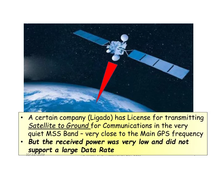
10/22/2019 Parkinson UAG Presentation Oct. 2019 23