
SLIDE 1
6:00 6:15 Welcome 6:15 7:00 Presentation 7:00 7:30 - - PowerPoint PPT Presentation
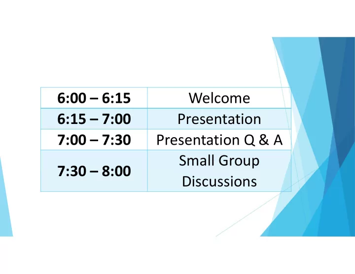
6:00 6:15 Welcome 6:15 7:00 Presentation 7:00 7:30 Presentation Q & A Small Group 7:30 8:00 Discussions Watershed Studies 2019 City of Madison Engineering Division Evening Overview Welcome (Hannah Mohelnitzky, City
City of Madison Engineering Division
Welcome (Hannah Mohelnitzky, City of Madison) Presentation (Matt Allie, City of Madison) Q&A (facilitated by Hannah Mohelnitzky, City of Madison) Wrap Up (Hannah Mohelnitzky, City of Madison) Breakout to Small Groups (City of Madison Staff)
Wisconsin's Changing Climate: Impacts and Adaptation. 2011. Wisconsin Initiative on Climate Change Impacts. Nelson Institute for Environmental Studies, University of Wisconsin‐Madison and the Wisconsin Department of Natural Resources, Madison, Wisconsin.
More rain More rain events greater than 3”
Recent Rain Events
July 21, 2016: 2.46” in 3 hours July 10, 2017: 3.87” in 4 hours June 16, 2018: 2.34” in 2.5 hours August 20, 2018: 6.78” in 8 hours
All rainfall t ot als t aken from t he Weat her Underground Meadowwood st at ion (KWIMADIS 1) in Madison, WI.
E Johnson Street, Madison, WI
KMKX Radar that was “bias corrected” using rain gauges by UW Professor Dan Wright
Recent storms have amplified known
inadequacies
Recent storms have revealed new storm sewer
deficiencies
Result: flood damage
Deming Way, Madison, WI
August 20th event:
substantial damage
Public infrastructure: $4
million
Private property: reported
$17.5 million, estimated $30 million
Odana Road (above), Glenwood Children’s Park (right), Madison, WI
Most damage on the West
Side
Mostly residential damage Some commercial damages Big losses!
Recent storms have amplified known
inadequacies
Recent storms have revealed new storm sewer
deficiencies
Result: flood damage
City’s plan
Complete watershed studies of impacted
areas
Develop solutions from watershed studies
Deming Way, Madison, WI
Annual exceedance probability (AEP): chance that a
rainfall event will occur in one year.
100‐yr storm = 1/100 (1%) AEP
Does NOT mean that a storm will only occur once in 100
years.
During a 30‐year mortgage, there’s a 26% chance of
experiencing a 100‐year (1%) event.
Annual Exceedance Probability (AEP) Chance of
Year Return Period or Average Recurrence Interval (ARI) 100% 1 in 1 1‐year 50% 1 in 2 2‐year 10% 1 in 10 10‐year 4% 1 in 25 25‐year 1% 1 in 100 100‐year 0.10% 1 in 1000 1000‐year
The “100‐Year” Storm
Recent Rain Events
July 21, 2016: 2.46” in 3 hours
10‐20% chance of occurring each year
July 10, 2017: 3.87” in 4 hours
2% chance of occurring each year
June 16, 2018: 2.34” in 2.5 hours
10‐20% chance of occurring each year
August 20, 2018: 6.78” in 10 hours
0.5% chance of occurring each year
All rainfall t ot als t aken from t he Weat her Underground Camelot Dr st at ion (KWIMADIS 87) in Madison, WI.
E Johnson Street, Madison, WI
What’s a watershed?
A watershed is the area of
land that drains precipitation (rain, snow, etc.) to a common low point, such as an inlet, stream, or lake.
Determined by surface terrain
and underground pipe system.
Madison has separate
storm and sanitary sewers
Storm sewer system is
NOT the same as the sanitary sewer system
https://www.azstorm.org/stormwater ‐101/storm‐vs‐sanitary‐sewer
Sanitary sewer drains
residential (toilets, showers, kitchen sinks, etc.), commercial and industrial wastewater streams
Sanitary sewer transports
wastewater to Madison Metropolitan Sewerage District (MMSD) treatment plant
Sanitary infrastructure
includes:
Manholes Household lateral pipes Main collector pipes https://www.azstorm.org/stormwater ‐101/storm‐vs‐sanitary‐sewer
Our stormwater drains to
local surface waters
We try to treat for
nutrients and sediment
Storm infrastructure
includes:
Curbs and gutters Inlets Pipes Channels (greenways) Ponds
https://www.azstorm.org/stormwater ‐101/storm‐vs‐sanitary‐sewer
Greenway at Owen Conservation Park Above: 96” pipe on University Ave (2013) Below: storm sewer inlet on W Doty St
In many watersheds, flooding is not
driven by Lake Mendota level
Lake Mendota level: controlled by
Dane County
Tenney Lock
Yahara Lakes function as a system
Solution to problems is increased
conveyance through lake chain
Website:
https://lwrd.countyofdane.com/Yah ara‐Chain‐of‐Lakes‐Lake‐Levels‐ Task‐Force
https://www.wiscontext.org/yahara‐watershed
Flash flooding: when storm sewer
system cannot handle high amounts
Comparative example: a traffic jam
Too many cars of the Beltline during
rush hour backups happen
During a storm, more water tries to
move through the storm sewer system backups happen
Beltline, looking west from Park Street, WisDOT
Tools have changed in the last five decades. Old tools made data gathering and stormwater modeling difficult.
Photo above: https://www.vintag.es/2018/0 8/life‐before‐autocad.html
Changing public design standards and past limited private
design standards have led to flash flooding.
Lax historical building requirements created hard‐to‐solve
flooding problems on private property which cannot be easily corrected.
storms
storms with 10% chance of
storms required for new development
depressions
Road reconstruction, storm sewer is expensive
but long‐lasting
Road reconstruction cost = approximately $500‐
$2,000/ft
2% City infrastructure is upgraded annually Average life:
Street=30‐50 years Pipes=50‐100 years
Storm Water Utility bill
2018 increased 2.3% (avg. residential increase of
$2.15/year)
2019 increased 10.1% (avg. residential increase of
$9.60/year)
96” pipe tunneling on University Ave, Madison, WI (2013)
Find out why flooding happens in
certain locations.
Example output from watershed modeling
Find out why flooding happens in
certain locations
System goals
Eliminate flooding from storm sewer
during storms with a 10% chance of
Find out why flooding happens in
certain locations
System goals
Eliminate flooding from storm sewer
during storms with a 10% chance of
Cars can pass down the middle (highest)
part of the street during a storm with a 4% chance of occurring each year (~5”
Winding Way, Madison, WI
Find out why flooding happens in certain
locations
System goals
Eliminate flooding from storm sewer during
storms with a 10% chance of occurring each year (4” of rain in a day)
Cars can pass down the middle (highest) part
Structure (buildings, infrastructure and
homes) and major roadway damage is eliminated for storms with a 1% chance of
Regent St at Kenosha Ave, Madison, WI
Find out why flooding happens in certain
locations
System goals
Eliminate flooding from storm sewer during
storms with a 10% chance of occurring each year (4” of rain in a day)
Cars can pass down the middle (highest) part
Structure and major roadway damage is
eliminated for storms with a 1% chance of
Flooding extents known during storms with a
0.2% chance of occurring each year (8.96” of rain in a day)
Tenney Park, Madison, WI
Find out why flooding happens in
certain locations
System goals Test solutions
Lots more detail gets added in
final design
Will help prioritize and budget
future projects
Example of a stormwater model
Retrofitting infrastructure takes time and money Repairs are not always easy, popular, or cheap Not always a good solution Property owners will need to create solutions too Solutions will need broad community cooperation Groundwater problems not easily addressed by
Create Drainage Model Identify Flooding Impacts Develop Engineering Solutions Prioritize & Budget
Model Existing Conditions & Predict Future Flood Risk Analyze Solutions on Watershed Scale, Rank & Budget
Create Drainage Model Identify Flooding Impacts Develop Engineering Solutions Prioritize & Budget
Gather model input data Install equipment and measure rainfall and channel flow Build computer models to represent rainfall‐runoff‐routing Compare model to data Determine extent of past flooding
What does modeling the East Badger Mill Creek watershed involve?
Watershed area: 1,272 acres (about 2 square miles) 18 miles of City‐owned storm sewer 2.7 miles of City‐owned major drainage‐ways (open channels) About 3,700 parcels, primarily residential ~500 inlets
What you might see in the watershed
USGS station (left) and stage gauge (above). Photos courtesy of Bill Selbig (USGS). Above: surveyor in the field. Photo courtesy of Amber Lefers (AE2S).
Create Drainage Model Identify Flooding Impacts Develop Engineering Solutions Prioritize & Budget
See how well existing storm sewer system meets goals
Commerce Drive near Plaza Drive, Madison, WI
Create Drainage Model Identify Flooding Impacts Develop Engineering Solutions Prioritize & Budget
Must be holistic Not “move the problem elsewhere” Account for climate change Look at trending increases in storm frequency and intensity Consider long term maintenance needs Provide benefits relative to cost
Create Drainage Model Identify Flooding Impacts Develop Engineering Solutions Prioritize & Budget
What are some general options?
Improve pipe and/or inlet capacity Safe overflow paths Reroute flow Increase storage / detention Flood‐proof buildings Local landscaping / grading Solutions on private property to structures or land
Create Drainage Model Identify Flooding Impacts Develop Engineering Solutions Prioritize & Budget
Improvements require time and money
Some solutions are long‐term, sustained community efforts (green infrastructure) Some solutions are discrete, high capital‐cost projects (box culverts, pond, etc.)
Solutions prioritized based on:
Frequency, severity and damage (cost‐benefit) Emergency response routes Areas with other projects scheduled (road repair, etc.) Within a Neighborhood Resource Team area
Winter – Spring 2020: Create and Calibrate Model Spring 2020: Identify Flood Impacts Spring – Summer 2020: 2nd Public Meeting Summer – Fall 2020: Evaluate Solutions Fall 2020: 3rd Public Meeting End of 2020: Complete Watershed Study
Self‐report Online Survey: document
and share data during rain events
www.cityofmadison.com/flooding
WE NEED YOU TO REPORT ON‐LINE TO INFORM OUR STUDY!
Understand local drainage and how to
protect your property
Install backflow preventers and sump
pumps
Consider supplemental insurance Focus group participation
Self‐report Online Survey Understand local drainage and
how to protect your property
www.cityofmadison.com/flood
protection
Install backflow preventers and
sump pumps
Consider supplemental
insurance
Focus group participation
Self‐report Online Survey Understand local drainage and
how to protect your property
Install backflow preventers and
sump pumps
Consider supplemental
insurance
Focus group participation
Self‐report Online Survey Understand local drainage and how to protect your property Install backflow preventers and sump pumps Consider supplemental insurance – contact your private
insurance agent for more information
Focus group participation
Self‐report Online Survey Understand local drainage and how to protect your property Install backflow preventers and sump pumps Consider supplemental insurance Focus group participation: for regional issues that affect more
than one person
Be a good neighbor! Understand how your water could have
negative impacts on your neighbor’s property.
Install rain gardens and/or rain barrels etc. Have a plan to protect yourself during a flash flood warning. Become a better steward of your watershed. Adopt an Inlet Remove leaves from the street http://www.ripple‐effects.com/
www.cityofmadison.com/flooding
Report Flooding Survey Individual Watershed Studies Pages
Sign up for updates!
How you can prevent flooding at your
home
Everyday Engineering Podcast
Historic Flooding and Basement
Drainage episodes
Focus Groups
Here’s why you should come:
We’ve already hosted nearly 30 focus
groups in the past two months
Our engineers come out to you, in your
neighborhood
Walk and talk Get questions answered Residents shared: 1) Flooding experiences 2) Maintenance concerns 3) Feelings about potential solutions
A community‐based program
providing outreach, crisis counseling, and support to communities impacted by severe storms, flooding, land‐ slides, straight‐line winds, and tornadoes in the summer of 2018.
Contact Project Recovery
By phone: 1‐844‐260‐7029 (toll free) By email:
ProjectRecovery@couleecap.org
Spring – Summer of 2020
Present stormwater and flood model findings Specific to the watershed Refine data and model Use as a ‘fact check’ with residents
City Contact Info:
Dunn’s Marsh: Caroline Burger cburger@ cityofmadison.com (608) 266-9721 East Badger Mill Creek: Matt Allie mallie@ cityofmadison.com (608) 266-4058 Greentree/ McKenna:
Matt Allie
mallie@ cityofmadison.com (608) 266-4058