
SLIDE 1
April 23, 2014 | JHS 210 Elizabeth Blackwell| 6:00 - 8:30 PM
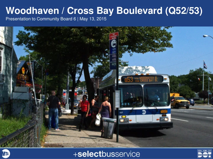
Woodhaven / Cross Bay Boulevard (Q52/53)
Presentation to Community Board 6 | May 13, 2015
Woodhaven / Cross Bay Boulevard (Q52/53) Presentation to Community - - PowerPoint PPT Presentation
Woodhaven / Cross Bay Boulevard (Q52/53) Presentation to Community Board 6 | May 13, 2015 April 23, 2014 | JHS 210 Elizabeth Blackwell| 6:00 - 8:30 PM Presentation outline 1. Project background 2. Proposed corridor design 3. Traffic analysis
April 23, 2014 | JHS 210 Elizabeth Blackwell| 6:00 - 8:30 PM
Presentation to Community Board 6 | May 13, 2015
2
3
4
5
Improved fare collection Transit signal priority Passenger Information Stations & Amenities Bus lanes Branding
6
Speeds have increased by 15-23%
Trips increased by 10%
Customer satisfaction of 95%+
Crashes reduced by over 20%
7 SBS routes in operation, carrying
7
8
9
10
All Q53 Northbound Trips
In Motion 57% Red Lights 25% Bus Stops 18%
11
12
Total crashes by intersection (2008-2012)
fatality
13
14
15
Existing Conditions & Analysis 3 Design Concepts & Screening Preferred Corridor Design Final Design & Engineering 2014 2016-2017 2015
16
17
COMMUNITY INPUT
TECHNICAL ANALYSIS
Concept 1: Offset Bus Lanes Concept 2: Main Road Bus Lanes Concept 3: Median Bus Lanes
Concept 2: Main Road Bus Lanes for Woodhaven Boulevard
18
19
– No bus lanes – Improved curbside bus stops
– Designated bus-only station areas – Improved bus stops / transfers
– Main road bus lanes – All buses use median stations
– Offset bus lanes – SBS buses stop at bus bulbs – Local buses stop at the curb
– No bus lanes – Targeted transit priority treatments – Improved curbside bus stops
20
CB6
Long pedestrian crossing distance with no refuge All lanes are mixed traffic; lack
Wide roadway encourages speeding Bus stops lack amenities Left turns create congestion and safety issues
21
Curbside bus lanes in the mainline roadway Calmed service roads with parking SBS stations and Local bus stops on side median Medians with pedestrian refuges and greening Separates local and thru traffic
22
Left turns at designated left-turn bays Right turns from the service road All buses stop at median stations Buses and thru traffic in the main roadway Slip openings allow vehicles to move between the main road and the service road local access and parking in the service roads
23
Sample plan for illustrative purposes
2nd mid-block station access point (where feasible) station access from intersection crosswalk
Local / Express Boarding Area
Maneuvering space
SBS Boarding area
fencing / screen
24
Avinguda Diagonal, Barcelona, Spain Pelham Parkway, Bronx EL Grant Highway, Bronx 25
real-time information shelters / fencing / windscreens
San Bernardino , CA – Bus rapid transit station (source: Architectural Record) Philadelphia, PA – 33rd & Dauphin Bus Loop (source: SEPTA)
public art benches and seating trees and greening 26
27
28
29
Screenshot of Woodhaven Blvd & Metropolitan Av AM Peak Period from screening analysis
30
2 4 6 8 10 12 14 No Build Concept 2 Average Vehicle Travel Time (minutes) Northbound (peak direction) Southbound (off-peak direction)
Simulation Model Results – AM Peak
Woodhaven Blvd from 68th Rd to 86th Rd
31
(local bus will still stop at Atlantic Av)
32
33
34
35
36
37
38
April 23, 2014 | JHS 210 Elizabeth Blackwell| 6:00 - 8:30 PM