SLIDE 1 What are (Northern California) floodplains?
- Alluvial flats formed by stream
flood deposition of sediment
- Least frequently flooded part of
river channel system.
- Alluvium:
- Fine sediment (clay, silt, fine
sand – suspended load, “muddy”, slow to settle, quiet backwaters.
gravel, coarse sand – mostly bedload (near-bed), high velocity channelized flows
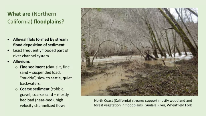
North Coast (California) streams support mostly woodland and forest vegetation in floodplains. Gualala River, Wheatfield Fork
SLIDE 2 VALLEY WALLS OR HILLSLOPES ALLUVIUM (river sediment with groundwater, hyporheic flow) Stream occupies whole floodplain Spreading slower flow
BELOW BANKFULL DISCHARGE
FLOODPLAIN EMERGENCE (flows confined to channel)
OVERBANK FLOOD FLOWS
FLOODPLAIN SUBMERGENCE ALLUVIUM (river sediment with groundwater, hyporheic flow) Stream occupies channel Concentrated rapid flow
natural levees backwater backwater recharge
What are floodplains?
SLIDE 3 Garcia River Watershed
Russian River Watershed
Where are major floodplains in the Gualala River watershed?
LOW GRADIENT, LOW ELEVATION RIVER AND TRIBUTARY REACHES
Local Pacific coastal watersheds
SLIDE 4
MOST SEAWARD GUALALA FLOODPLAIN:
GUALALA POINT MARSH
FRESHWATER MARSH ABOVE SEA LEVEL FLOODED BY HIGHEST RIVER FLOWS AT HIGH TIDE, AND HIGH NON- TIDAL LAGOON STANDS VEGETATION: TULE, RUSH, SEDGE, BULRUSH, SPIKERUSH
SLIDE 5 MILL BEND FLOODPLAIN 1872
Photo source: Tammy Durston & Steve Oliff, 2010. Annapolis and the Gualala River
FLOODPLAIN
Willow riparian thicket
Non-tidal LAGOON HIGH STAND (mouth closed)
POINT BAR (frequently flooded)
SLIDE 6 AGGRADED BRAIDED BARS Masked by high non-tidal lagoon stands (mouth closed) POINT BAR (frequently flooded) FLOODPLAIN Shallow channel
Terminal bar
MILL BEND FLOODPLAIN Circa 1920 Low elevation close to aggraded channel bars Photo source: Susan M. Clark, 2009. The Sea Ranch
Sand spit
Willow riparian thicket
SLIDE 7
Floodplains are infrequently occupied depositional channels.
Wheatfield Fork, alder riparian floodplain during flood, upstream of Annapolis Road bridge, Feb 21, 2019
SLIDE 8
Dec 31, 2005 Feb 21, 2019 BRAIDED CHANNEL BARS GROW AND COALESCE INTO ALDER RIPARIAN FLOODPLAIN WOODLAND Wheatfield Fork, upstream of Annapolis Rd Bridge
SLIDE 9
ALDER RIPARIAN WOODLAND SEDIMENT and DEBRIS TRAPPING IN FLOODPLAIN, VALLEY CROSSING FEBRUARY 26-27 2019
SLIDE 10
FLOODPLAIN FORESTS TRAP FINE SEDIMENT THAT OTHERWISE WOULD BE TRANSPORTED AND DEPOSITED IN CHANNEL HABITATS Thick storm flood deposits are trapped and stabilized by floodplain vegetation, improving water quality and salmonid spawning and rearing habitat in stream channels
SLIDE 11
FLOOD-TOLERANT AND BURIAL-TOLERANT VEGETATION DOMINATES GUALALA RIVER FORESTED FLOODPLAINS
Redwood, pepperwood, alder, willow, blackberry – woody dominant vegetation Horsetail, sedge, rush, ferns – herbaceous dominant vegetation
SLIDE 12
SLIDE 13
Jan 2, 2006 Valley Crossing
SLIDE 14
FLOOD-TOLERANT AND BURIAL-TOLERANT VEGETATION DOMINATES GUALALA FLOODPLAINS
SLIDE 15
FLOODPLAINS STORE AND RELEASE DEADWOOD CHANNEL-FORMING HABITAT STRUCTURE ELEMENTS TRANSPORTED DURING FLOODS South Fork Gualala River upstream of Annapolis Road Bridge, Feb 21, 2019
SLIDE 16
Floodplains trap, stabilize, store, and release sediment
Wheatfield Fork Gualala River west of Annapolis, 2010
SLIDE 17
IDENTIFYING THE FLOODPLAIN Look for persistent, recurrent high water mark indicators. Flood sediment-stained high water lines, 2016, 2019.
SLIDE 18
SUSPENDED FLOOD DEBRIS in floodplain shrub, woodland, or forest canopy
SLIDE 19
- Juvenile salmonid growth & rearing habitat:
abundant invertebrate food for steelhead, Coho salmon available during intensive feeding periods while floodplains are submerged.
- Wetlands - extensive
- Redwood Forest – fastest growth and development to mature
forest, largest trees
- Water Quality – major trap (sink) and stabilization capacity for
fine sediment
- Wildlife and Rare Plant Habitat –
Beaver dam and pond habitat = salmonid rearing habitat (extirpated) Rare floodplain plants = wetland plants
Why are floodplains important, compared with uplands or channels? What ecosystem services do they provide?
SLIDE 20 NEW FISHERIES SCIENCE CONSENSUS (ca. 2001-present): HIGH IMPORTANCE OF FLOODPLAIN REARING HABITATS FOR RAPID JUVENILE SALMONID GROWTH TO CRITICAL SIZE IN-CHANNEL VERSUS OFF-CHANNEL COHO AND STEELHEAD REARING HABITAT Juvenile salmonids migrate into floodplains during or following high flows…to seek winter rearing habitat and refuge from flow events Significantly higher growth rates for juvenile salmonids rearing in the floodplain as opposed to those rearing in riverine habitats Today, restoration of floodplain habitat is regarded as especially important for juvenile salmon growth and survival (Sommer et al. 2001, Jeffres et al. 2008). Jeffres, C. A., J. J. Opperman, and P. B. Moyle. 2008. Ephemeral floodplain habitats provide best growth conditions for juvenile Chinook salmon in a California River. Environmental Biology of Fishes 83:449–458. Sommer TR, Nobriga ML, Harrell WC, Batham W, Kimmerer WJ. 2001. Floodplain rearing of juvenile Chinook salmon: evidence of enhanced growth and
- survival. Can J Fish Aquat Sci 58:325–333
KEY FACTOR: INVERTEBRATE PREY (FOOD) AVAILABILITY IN FLOODPLAINS, REDISTRIBUTED BY FLOODING OF WETLANDS AND TERRESTRIAL HABITATS; FOOD WEB STRUCTURE DISTINCT FROM CHANNEL AQUATIC HABITATS (favors salmonids over competitor fish)
SLIDE 21 Comparison of juvenile Chinook salmon reared on a restored Cosumnes River floodplain (right) and in the river’s main
- channel. Photo by Jeff Opperman, 2006
FLOODPLAIN REARED CHINOOK SALMON CHANNEL REARED CHINOOK SALMON
- Ephemeral floodplain habitats
supported higher growth rates for juvenile Chinook salmon than more permanent habitats in either the floodplain or river
- When flows and turbidity were
high, there was little growth and high mortality
- As river stage falls, floodplain
water velocity decreases, water warms, and clarity increases (fine sediment deposited)
- Importance of terrestrial and
wetland vegetative structure for promoting primary and secondary production
SLIDE 22 Large floodplain surface area relative to channel, abundant vegetation, high productivity, low velocity: submerged floodplain = refuge for juvenile salmonids. Risk/reward – growth versus stranding mortality
Valley Crossing, confluence Wheatfield and South Forks Gualala River, December 2014. Steelhead parr in floodplain pool.
SLIDE 23 Mature Redwood Floodplain Forest
Roots grow near shallow groundwater Reduced competition with flood- intolerant trees Fastest recovery of
structure, size in floodplain forest
SLIDE 24
Widespread floodplain seasonal wetlands
Thick sedge canopy roughness traps sediment Dense roots stabilize deposited sediment Moist organic matter, detritus produce abundant terrestrial insect prey of salmonids, available during floods
SLIDE 25
Rare obligate wetland plants (99% occurrence in wetlands) in floodplain forest Fringed corn-lily (Veratrum fimbriatum)
SLIDE 26 Conservation of Gualala River Floodplain Redwood Forest: What should we do? Top 3 actions
DISTURBANCE BY TIMBER HARVEST OPERATIONS, just as the Forest Practice Rules prescribe.
- Let recovering floodplain redwood refuges mature; minimize
logging areas near wetlands and stands of largest redwoods
- Minimize ground disturbance of seasonal wetlands
- Don’t mine permanent gravel pits in evolving floodplains
- Don’t drain floodplain wetlands for road use in the name of
sediment management
- ACCEPT NO SUBSTITUTES: “IN LIEU” PRACTICES inferior and
incomplete protection, unsuitable for seasonal wetlands
SLIDE 27 Large slough sedge meadow (sward) Carex obnupta. Special-status wetland plant community, CDFW NO DISCLOSURE OR IMPACT ASSESSMENT IN GRT FLOOD PRONE THPs; CAL FIRE DENIED EXISTENCE OF SEASONAL WETLANDS Ground disturbance impacts
logging operation
- Log skidding,
- Heavy wheeled or tracked
equipment operation Reduces flood sediment trapping capacity Reduces food web support for salmonids
SLIDE 28
- Don’t mine permanent gravel pits in evolving
floodplains
- Don’t drain floodplain wetlands for road use in
the name of sediment management
SLIDE 29
- Mining mechanically removes riparian vegetation that builds floodplains
- Prevents floodplain forest from forming, maintains hot, dry “holes” in floodplain
SLIDE 30
- 2. PROPERLY INVENTORY, ASSESS and PROTECT
IMPORTANT BIOLOGICAL RESOURCES IN THE FLOODPLAIN, including
- seasonal wetlands, rare plants
- seasonal salmonid rearing (ephemeral flood pulse
feeding)
- sediment trapping capacity
California harebell Fringed corn-lily Slough sedge SEASONAL WETLANDS STEELHEAD REARING SEDIMENT TRAPPING VEGETATION
SLIDE 31
Floodplain haul road erosion control using invasive non-native ryegrass
SLIDE 32
FLOODPLAINS.
- North Coast: Restore estuarine marshes and
floodplains and improve lower river riparian corridors to increase juvenile-to-smolt survival of
- salmonids. (Moyle et al. 2008)
- Help deeply incised creeks and side-channels recover:
jam with woody debris and sediment, dropped trees
- Reintroduce beavers as ecological engineers of
floodplain and side-channel ponds, perennial wetland, to recover productive salmonid habitat
- Restore or enhance side-channels, alcoves in
floodplains