
SLIDE 1
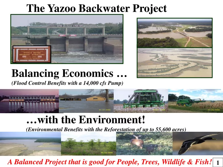
The Yazoo Backwater Project Balancing Economics …
(Flood Control Benefits with a 14,000 cfs Pump)
…with the Environment!
(Environmental Benefits with the Reforestation of up to 55,600 acres)
The Yazoo Backwater Project Balancing Economics (Flood Control - - PowerPoint PPT Presentation
The Yazoo Backwater Project Balancing Economics (Flood Control Benefits with a 14,000 cfs Pump) with the Environment! (Environmental Benefits with the Reforestation of up to 55,600 acres) A Balanced Project that is good for People, Trees,
(Flood Control Benefits with a 14,000 cfs Pump)
(Environmental Benefits with the Reforestation of up to 55,600 acres)
41% of the land area in the US drains into the Mississippi River Drainage Basin The Mighty Mississippi River Basin
The MS River Drainage Basin includes 41% of the continental United States. This is water from parts of 31 States and 2 Provinces of Canada. 2
Federal Budget was $3 Billion
3
Levees Channel Improvement Major Tributary Basin Improvements Floodways The 1927 Flood awakened the Nation’s conscience to the need for a comprehensive program to control the MS River. From destruction and ruin came the Flood Control Act of 1928 which authorized the Mississippi River & Tributaries Project (MR&T) - the nation’s first comprehensive flood control system. 4
EUDORA FLOODWAY REMOVED FROM MR&T FLOOD CONTROL ACT 1941 YAZOO BACKWATER AREA
The Flood Control Act of 1941 authorized the Yazoo Backwater Project to provide protection from higher stages on the MS River resulting from the removal of the Eudora Floodway Project in Arkansas and Louisiana from the MR&T Project. The YBW Project consisted of drainage structures, levees and pumps to remove the rainwater out of the Delta during a highwater event on the MS River. 5
Everybody has their Pump …… except the Mississippi South Delta!
STATE NAME BASIN
YEAR COMPLETED ARK Huxtable 2,013 1977 - 12,200cfs ARK Graham- Burke 227 1964 ARK Lake Chicot 350 1987 – 6,500 cfs LA River Styxx 37 1994 LA Fool River 44 2001 LA Haha Bayou 113 1964 LA Tensas- Cocodrie 582 1986 – 4,000 cfs MS Yazoo Backwater 4,093 ??? - 14,000cfs
Memphis Little Rock Greenville Vicksburg New Orleans Yazoo Backwater Huxtable Lake Chicot River Styxx Fool River Haha Bayou Tensas-Cocodrie Graham Burke Monroe
Facts:
a 200 mile radius of the Backwater Area!
when capacity is compared to drainage basin!
This is not a unique situation! 6
There are 4 Backwater Areas along the MS River
These Backwater Levees have Drainage Structures to allow water to pass through the levee during low- water and they can be shut during high water times to keep the MS River from backing into the basin. During high water times when the gates are closed – any rainfall that occurs in the basin gets backed up behind the closed gates. A pump is required to remove the rainwater. 3 Backwater Areas have an adequate pump in place. Unfortunately the Yazoo Backwater Area does not have a pump in place! Pumping Plants to evacuate stormwater (1) St. Francis – AR & MO Huxtable built in 1977 (2) White River - AR Graham-Burke built in 1964 (3) Red River -LA Tensas-Cocodrie built in 1986 (4) Yazoo River - MS NONE
Backwater Areas of the MR&T Project 7
All the rainfall in the MS Delta shown on this map must exit through the Steele Bayou Structure to enter into the Yazoo River to the MS River.
(2.62 Million Acres) Steele Bayou Drainage Structure
Greenville Greenwood Clarksdale Vicksburg
Rhode Island - 1,045 sq. miles Delaware – 1,954 sq. miles Connecticut – 4,845 sq. miles
8
1928 FCA (Flood Control Act) Congress passes the 1st comprehensive Flood Control Project. The “MR&T Project” consists of Levees, Floodways & Cut-offs. 1936 FCA Congress extends Federal responsibility to sub-basins (i.e. the Yazoo Basin). 1941 FCA Arkansas abandons the Eudora Floodway & Mississippi realizes this will flood the MS South Delta. Congress authorizes the Yazoo Backwater Project – Drainage Structures, Backwater Levees & Pumps. 1960’s The Corps starts constructing the Drainage Structures & Backwater Levees. 1973 Flood 1,000,000 acres flooded in the MS South Delta (last MS River Flood was in 1950). 9
Rolling Fork, MS Hwy 16 over Little Sunflower River Hwy 14 over Big Sunflower River
100 Year Event
Flooded Houses
10
75.47’ MS RIVER
MAY 15, 1973 FLOODING EVEN WITH PUMPS!
NO FLOODING IN LOUISIANA BECAUSE THEY HAD PUMPS IN PLACE!
1973 FLOOD
CROSS-SECTION ELEV 96’ 114.14’
MISSISSIPPI LOUISIANA
11
1978 The Drainage Structures and Backwater Levees are completed. WRDA of 1986 – Implemented Cost Sharing on Projects March 1986 Yazoo Backwater Pumps awarded to contract. Senate passes WRDA with date of enactment to be at conference (Oct. 26, 1986). May 1986 On May 5, 1986 dirt is moved on the Yazoo Backwater Pump Project. On May 15, 1986 House passes WRDA with date of enactment (Oct. 26, 1986). October 1986
Set grandfather date of April 30, 1986 – affecting 1 project in the USA – the Yazoo Backwater Pumps. WRDA of 1996 Congress sets the date of award as the date the project is started. This re-stored 100% Federal responsibility to the Pumps. 12
Pump Station Site Coffer Dam (1987) Pump Inlet Channel (1987) Pump Outlet Channel (1987) Connecting Channel (1978) Steele Bayou Drainage Structure (1969) Yazoo Backwater Levee (1978) Yazoo River Hwy 465 Steele Bayou To the MS River
13
Completed in 1969 All the components of the Yazoo Backwater Project are in place, except for the Pumps. The YBW Project works flawlessly during MS River high water events, as long as there is no rainfall in the Delta. The Yazoo Backwater Levee and Drainage Structures keep the MS River from backing up the Yazoo River and flooding the South Delta. If any rainfall occurs in the Delta while the gates are closed on the Structure, the water will flow down to the gates and stop and begin to back-up into the South Delta. This water will stay here until the MS River is low enough to open the gates on the Structures. The pumps will allow the water to be pumped over the levee while the gates are closed. 14
After 11 months & 50 hours of meetings, the proponents compromised and were rewarded with deceit, filibuster and violation of agreements. In Search of a Functional Solution:
for multiple purposes
fee simple acquisition
to lands below 2-yr flood plain 15
PLAN PUMP? ON/ OFF ELEV. REFOREST EASEMENT MAINTAIN LOW-WATER?
1 NO
“DO NOTHING”
NO 2 NO
“NO PUMP”
NO 2a NO
“NO PUMP”
NO 2b NO
“Ring Levees”
NO 2c NO
Shabman & Zepp
NO 3 YES 80’growing 85’ winter
“1986 PLAN” Full Structural Compensatory Mitigation
YES 4 YES 85’ 37,200 ac. YES 5 YES 87’
1-YEAR FLOOD EVENT
55,600 ac. YES 6 YES 88.5’
JURISDICTIONAL WETLANDS
81,400 ac. YES 7 YES 91’
2-YEAR FLOOD EVENT
124,400 ac. YES
Non-structural No Pump – Trees Combination Plans Pump & Reforestation Pump Only
16
Original Project (1982) Recommended Plan (2007) Pump Capacity
On/Off (elevation)
(1 year flood plain)
Acres Flooded when Pumps turn on
Reforested Land Fee purchase Mitigation of
Non-structural feature - Reforestation Easements
Protecting Local County Tax Base
17
1941 Arkansas abandons Eudora Floodway - Congress authorizes the Yazoo Backwater Project to offset 6’- 8’ higher stages on MS River at Vicksburg 1927 1927 Flood - 16.6 million acres flooded, 246 lives lost, 700,000 displaced. 1928 Flood Control Act of 1928 Congress authorized - levees, floodways, cutoffs, and channel improvements 1936 Flood Control Act of 1936 Congress extends Federal responsibility to sub-basins - i.e. Yazoo Basin 1973 1973 Flood - 1 million acres flooded for more than 40 days Post flood evaluation: “cutoffs” 4’-6’ less efficient than projected 1978 YBW Levee, Connecting Channel, and drainage structures completed 1982 White House & OMB administratively order reduced pump size to 10,000 cfs 1986 Pump contract awarded – Completed Coffer Dam & Inlet & Outlet Channels WRDA 1986 - Congress strips full federal responsibility - local cost-sharing 1996 WRDA 1996 - Congress restores full federal responsibility 1997 Corps facilitates workshops with cooperating agencies review of YBW Project 1998 MS Levee Board facilitates Consensus meetings 2000 Draft Report for the Yazoo Backwater Project released 2007 Final Report for the Yazoo Backwater Project released 2008 EPA vetoes the Yazoo Backwater Project 18