
SLIDE 1
Photos Backwater reached 95.2 450,000 acres underwater 97 - - PowerPoint PPT Presentation
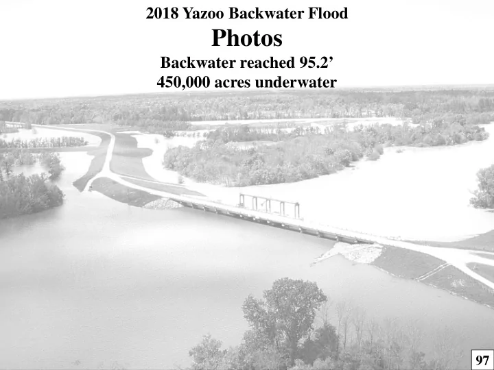
2018 Yazoo Backwater Flood Photos Backwater reached 95.2 450,000 acres underwater 97 RIVERSIDE 99.0 LANDSIDE 95.2 170,000 acres of Cropland Flooded 280,000 acres of Trees Flooded 450,000 acres Total Flooded Photo of Steele
LANDSIDE – 95.2’
170,000 acres of Cropland Flooded 280,000 acres of Trees Flooded 450,000 acres Total Flooded
RIVERSIDE – 99.0’
Photo of Steele Bayou Structure taken March 22, 2018 at 2:30pm
Backwater at 95.2’ on March 22, 2018 170,000 acres of Farmland Flooded 280,000 acres of Trees Flooded 450,000 acres Total Flooded
HISTORIC BACKWATER FLOODS SINCE 1978
The YBW Levee was completed in 1978. 1973 got to 101.5’
BACKWATER at 95.2’
170,000 acres of Cropland Flooded 280,000 acres of Trees Flooded 450,000 acres Total Flooded
LOW-WATER BRIDGE ROAD
BACKWATER at 95.2’
170,000 acres of Cropland Flooded 280,000 acres of Trees Flooded 450,000 acres Total Flooded
BLANTON, MS CARY, MS EAGLE LAKE, MS
YBW LEVEE
BACKWATER at 95.2’
170,000 acres of Cropland Flooded 280,000 acres of Trees Flooded 450,000 acres Total Flooded
HWY 61 & YBWL HWY 61 & YBWL HWY 61 & CONNECTING CHANNEL
BACKWATER at 95.2’
170,000 acres of Cropland Flooded 280,000 acres of Trees Flooded 450,000 acres Total Flooded
FLOWEREE, MS
GOOSE LAKE ROAD GOOSE LAKE ROAD GOOSE LAKE ROAD
BACKWATER at 95.2’
170,000 acres of Cropland Flooded 280,000 acres of Trees Flooded 450,000 acres Total Flooded
LOW WATER BRIDGE ROAD LOW WATER BRIDGE ROAD LOW WATER BRIDGE ROAD
BACKWATER at 95.2’
170,000 acres of Cropland Flooded 280,000 acres of Trees Flooded 450,000 acres Total Flooded
GOOSE LAKE ROAD GANT/NEWMAN ROAD GOOSE LAKE ROAD
BACKWATER at 95.2’
170,000 acres of Cropland Flooded 280,000 acres of Trees Flooded 450,000 acres Total Flooded
HUNTER FORDICE CABIN & LAND
VALLEY PARK, MS HWY 61 @ VALLEY PARK, MS VALLEY PARK, MS
BACKWATER at 95.2’
170,000 acres of Cropland Flooded 280,000 acres of Trees Flooded 450,000 acres Total Flooded
VALLEY PARK, MS
The YBW Project achieves both Economic and Environmental Benefits! If the YBW Project had been in place since 2008 (when EPA vetoed the project) it would have prevented $373M in damages in the past 11 years alone!