SLIDE 1
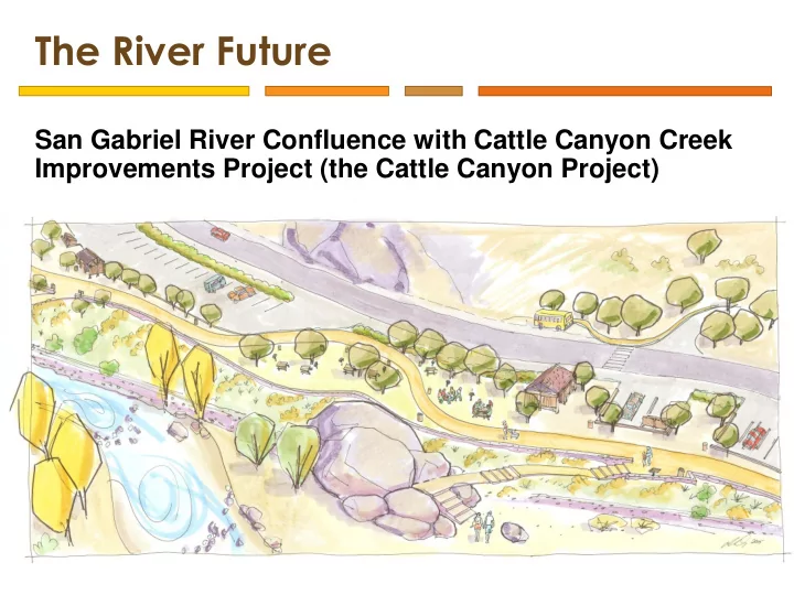
The River Future
San Gabriel River Confluence with Cattle Canyon Creek Improvements Project (the Cattle Canyon Project)
SLIDE 2 Collaboration
Agency Leads
Watershed Conservation Authority (Local Public Entity / JPA)
&
Angeles National Forest & San Gabriel Mountains National Monument
Planning Team Consultants
BlueGreen Consulting
Landscape Architecture / Planning
Environmental Science Associates
Environmental Consulting
Engaged Stakeholders
Non-Profit Organizations USFS Pacific Southwest Research Station Regularly Agencies
SLIDE 3 Camp Williams Camp Williams
Cattle Canyon Confluence
Coyote Flat / Parking Area Heaton Flat
Lower Canyon Upper Canyon
SLIDE 4
SLIDE 5
SLIDE 6
SLIDE 7
SLIDE 8
SLIDE 9
SLIDE 10 Purpose & Need
- Provide recreation facilities and infrastructure
- High quality
- Well-maintained
- Safe
- Accessible
- Consistent with visitors’ expectations
- Shift and concentrate recreational use to certain areas in
- rder to minimize adverse effects over a broader area
- Promote stewardship of public land by providing quality and
sustainable recreation opportunities that result in increased visitor satisfaction
SLIDE 11 Purpose & Need
- Allow for better management of the recreation resources
- n the Forest
- Improve riparian habitat conditions in certain areas and
make progress toward enhancing stream habitat conditions
- Restoring vegetation
- Minimizing invasive plants and noxious weed
- Development of management strategies to regulate access
SLIDE 12 History of the Project
2006 2008 2009 2012 Summer 2013 Summer 2014 Fall 2014 2015 2016/17
State Bond Freeze Inventory & Site Planning Outreach & Assessment ANF/WCA’s First Agreement Monument Establishment Student Investigation Initial Project Funding Environmental Review & Design Development
SLIDE 13 Visitor Assessment
Lower Canyon Upper Canyon Principle Researchers: Robert Brown, Ph.D. California State University, San Marcos Jerrell Ross Richer, Ph.D. Goshen College
SLIDE 14
SLIDE 15
SLIDE 16
LA County Park Needs Assessment
SLIDE 17
50 100 150 200 250 300 Median Mean Median Mean Median Mean Median Mean Oaks Total Lower Canyon Upper Canyon Grand Total
2013 and 2014 Vehicle Count Comparisons
2014 2013
SLIDE 18
Sustainable Site Access Model
Site Development Plan
SLIDE 19 Option 1 – Focus: Public Access
- Prioritize parking (417)
- 16 access points
- 4 new picnic facilities
- Barriers added along road to improve
safety and detour river access Restoration a part of all 3 options:
- Reduce impacts from informal trails
- Protect seeps/springs
- Preserve stream habitat in tributary
behind Oaks Picnic Area
- Non-native vegetation removal
and/or riparian plantings
- Phase out non-native “plantation”
tree plantings
Coyote Flat
SLIDE 20 Option 2 – Focus: River Path
- Continuous 1.5 mile “East Fork Scenic
Trail”
- 14 improved access points
- Loading/shuttle stops provided
- Angled and perpendicular parking bays
- Restoration (same as other options)
Confluence Area
SLIDE 21 Option 3 – Focus: Low Development
- Concentrate access
- 8 improved access points
- Parallel road side parking eliminated;
- ff-road parking provided
- Use maximized in lower canyon
- Restoration (same as other options)
Coyote Flat
SLIDE 22 Project Area Totals
Trailheads 4 Restrooms 10 Crosswalks 7 Designated Picnic Areas 6 East Fork Scenic Trails (mil.) 2.5 Interpretive Elements 4 River Access Points 6 USFS Visitor Kiosks 3 Bus/Shuttle Stops 3 Parking 270
Final Concept Site Plan
SLIDE 23
Oaks Area
Draft Site Shown Plan: under represents parking areas
SLIDE 24
Oaks Area
SLIDE 25
Junction & Confluence Areas
SLIDE 26
Coyote Flat, Overlook, & Firestation
SLIDE 27
Coyote Flat, Overlook, & Firestation
SLIDE 28
Heaton Flat
SLIDE 29
Site Type Management
Proposed to be managed as a Day Use Only area
SLIDE 30 Parking Distribution
Lower Canyon Parking Space Count: 169 Median Peak Use: ~120 Upper Canyon Parking Space Count: 101 Median Peak Use: ~140
SLIDE 31
East Fork Trail Schematic
SLIDE 32 Where We Are Today
Environmental Review Conceptual Development Report
SLIDE 33 Scoping
Preparation of a joint EIS/EIR ANF & WCA seek comments on:
- What environmental issues should be analyzed?
- Are there alternatives that should be evaluated?
- What mitigation measures would help avoid or minimize any
negative impacts? Public Meetings
Wednesday, November 16, 2016 6:00 p.m. to 8:30 p.m. Julia McNeill Senior Center 4100 Baldwin Park Boulevard Baldwin Park, California Saturday, November 19, 2016 11:00 a.m. to 1:30 p.m. Angeles National Forest Headquarters 701 North Santa Anita Avenue Arcadia, California
SLIDE 34 Scoping
Comments must be received no later than November 30, 2016 For comments or information:
Rob Romanek, Project Manager Watershed Conservation Authority 100 N Old San Gabriel Canyon Road Azusa, California 91702 rromanek@wca.ca.gov (626) 815-1019 x108
Project website with NOI/NOP and full project description:
www.wca.ca.gov/cattle_canyon www.fs.usda.gov/projects/angeles/landmanagement/projects
Jeremy Sugden, Recreation Officer ANF, SGM National Monument 110 N Wabash Avenue Glendora, California 91741 jmsugden@fs.fed.us (626) 335-1251 x222
SLIDE 35
SLIDE 36 National Monument Access Planning Efforts
San Gabriel Mountains National Monument Access Plan
Agency Leads Proposed Project Steering Committee
- Caltrans District 7
- LA County MTA
- LA County DPW
- COGs
- Foothill communities
- Foothill Transit
- EJ focused non-profits
- ANF
- SCAG
- WCA
Southern California Association of Governments
SLIDE 37
National Monument Access Planning Efforts
San Gabriel Mountains National Monument Access Plan This planning project will: 1) Initiate a collaborative process, including engagement and dialog among stakeholders; 2) Identify existing conditions; 3) Evaluate and prioritize opportunities; and 4) Develop an initial implementation strategy to create connections between the Monument and neighboring communities.
SLIDE 38
Funding
Grant Application Due Early Next Month Caltrans Fiscal Year 2017-2018 Sustainable Transportation Planning, Sustainable Communities Grant Program SCAG as applicant: To contribute highly skilled and experience transportation planning staff to manage and guide the development of this access plan WCA as sub-applicant: To contribute project management (as a match), bring knowledge of natural resources and recreational planning, experience with public land management, and a well-established cooperative partnership with ANF Grant request: ~$270,000