4. BRAZOS RIVER WHERE : YOU ARE HERE Grand Parkway LID 7 Levee - - PowerPoint PPT Presentation

4 brazos river
SMART_READER_LITE
LIVE PREVIEW

4. BRAZOS RIVER WHERE : YOU ARE HERE Grand Parkway LID 7 Levee - - PowerPoint PPT Presentation

4. BRAZOS RIVER WHERE : YOU ARE HERE Grand Parkway LID 7 Levee River Bank Segment to be Protected 4. BRAZOS RIVER WHY : Prevent future erosion and loss of river bank that could lead to LID 7 Levee Erosion of the Brazos River north bank


slide-1
SLIDE 1

WHERE :

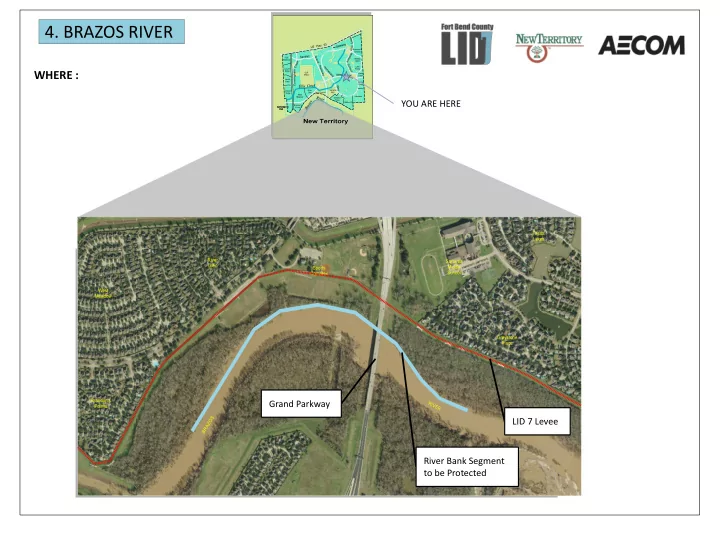
LID 7 Levee Grand Parkway River Bank Segment to be Protected YOU ARE HERE

  • 4. BRAZOS RIVER
slide-2
SLIDE 2

2017 Bank Line Maximum observed bank erosion is in excess

  • f 180 feet in the past 3 years, including over

120 feet after Hurricane Harvey. Minimum distance from the bank to the levee is approximately 200 feet. Erosion of the Brazos River north bank upstream of the SH 99 bridge

WHY :

Prevent future erosion and loss

  • f river bank that could lead to

levee failure and the potential for flooding throughout New Territory during a future extreme flood event on Brazos River. LID 7 Levee 2014 Bank Line Erosion of the Brazos River north bank downstream of the SH 99 bridge

  • 4. BRAZOS RIVER
slide-3
SLIDE 3

Example: Bendway Weirs Tie-in to Recently Constructed FBCGPTRA Erosion Protection Wall Bendway Weir High Performance Turf Reinforcement Example: Stabilized Bank with Scour Protection

Note: Representation shown is conceptual and subject to change based on further engineering evaluation.

HOW :

Utilize river training structures, engineered scour protection, and armored slopes to divert energy away from the outer bank, reduce scour potential, and prevent continued bank erosion.

Engineered Scour Protection System

Rock Riprap

Armored Slope with Rock Riprap

Stabilized Bank with Scour Protection

  • 4. BRAZOS RIVER