
SLIDE 1
South San Francisco Bay Shoreline Study Draft Feasibility Report - - PowerPoint PPT Presentation
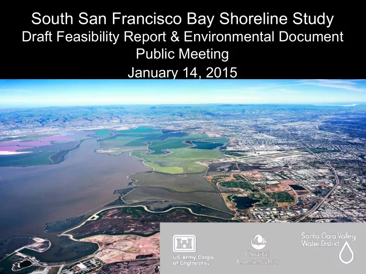
South San Francisco Bay Shoreline Study Draft Feasibility Report & Environmental Document Public Meeting January 14, 2015 Todays Agenda 6:40 pm Presentation on Shoreline Study Draft Feasibility and Environmental Impact Document
7
§ Residential, industrial, and commercial structures
► Community of Alviso ► San Jose/Santa Clara County Water Pollution Control Plant
* Figure above shows first significant damage
12
13
14
15
16
17
Photo: Cris Benton
20
A9 A10 A14 A11 A15 A13 A12 A18 A17 A16
21
A9 A10 A14 A11 A15 A13 A12 A18 A17 A16
24
A9 A10 A14 A11 A15 A13 A12 A18 A17 A16
25
A9 A10 A14 A11 A15 A13 A12 A18 A17 A16
27
A9 A10 A14 A11 A15 A13 A12 A18
A17 A16
28
¡ Flood Protection Levee Alignments ¡ Environmental Restoration ¡ 1 ¡ No Action ¡ No Action ¡ 2 ¡ Alviso North + WCPC South, 13.5 foot high levee ¡ Restoration of Pond A18, A12, A9-11, A13-15 + "bench” ¡ 3 ¡ Alviso North + WCPC South, 15.2 foot high levee ¡ Restoration of Pond A18, A12, A9-11, A13-15 + 30:1 slope ecotone ¡ 4 ¡ Alviso RR Spur + WCPC South, 15.2 foot high levee ¡ Restoration of Pond A18, A12, A9-11, A13-15 + "bench” ¡ 5 ¡ Alviso South + WCPC South, 15.2 foot high levee ¡ Restoration of Pond A18, A12, A9-11, A13-15 + "bench” ¡
All action alternatives include Railroad Swing Gate, Artesian Slough Tide Gate, Adaptive Management, and completion of Bay Trail connections ¡
29
30
¡ Flood Protection Levee Alignments ¡ Environmental Restoration ¡ 1 ¡ No Action ¡ No Action ¡ 2 ¡ Alviso North + WCPC South, 13.5 foot high levee ¡ Restoration of Pond A18 + "bench” ¡ 3 ¡ Alviso North + WCPC South, 15.2 foot high levee ¡ Restoration of Pond A18, A12, A9-11, A13-15 + 30:1 slope ecotone ¡ 4 ¡ Alviso RR Spur + WCPC South, 15.2 foot high levee ¡ Restoration of Pond A18, A12, A9-11, A13-15 + "bench” ¡ 5 ¡ Alviso South + WCPC South, 15.2 foot high levee ¡ Restoration of Pond A18, A12, A9-11, A13-15 + "bench” ¡
31
¡ Flood Protection Levee Alignments ¡ Environmental Restoration ¡ 1 ¡ No Action ¡ No Action ¡ 2 ¡ Alviso North + WCPC South, 13.5 foot high levee ¡ Restoration of Pond A18 + "bench” ¡ 3 ¡ Alviso North + WCPC South, 15.2 foot high levee ¡ Restoration of Pond A18, A12, A9-11, A13-15 + 30:1 slope ecotone ¡ 4 ¡ Alviso RR Spur + WCPC South, 15.2 foot high levee ¡ Restoration of Pond A18, A12, A9-11, A13-15 + "bench” ¡ 5 ¡ Alviso South + WCPC South, 15.2 foot high levee ¡ Restoration of Pond A18, A12, A9-11, A13-15 + "bench” ¡
32
33
34
36
38
December 19 ,2014 – February 2, 2015: Public Review Period March – July 2015: Additional analysis and changes to draft document
August 2015: Final Draft of Feasibility Study/EIS/EIR Complete and submitted to Corps Headquarters
September 2015: Civil Works Review Board September- October 2015: State and Agency Review November 2015: HQ USACE Final Coordination of Feasibility Study/ EIS/EIR December 2015: Chief of Engineers Signs off on Report January 2016: Report Transmitted to Congress
Identification
Recommended Plan
Draft EIS and Feasibility Report Public Meeting Final EIS and Feasibility Report Potential Congressional Construction Authorization Potential Congressional Construction Appropriation Construction Begins Begin Detailed Design