
SLIDE 1
Environmental, Earth, & Ocean Sciences Capstone Project
Gwen Richards and Caitlyn Mello Professor Anamarija Frankic University of Massachusetts Boston May 2011
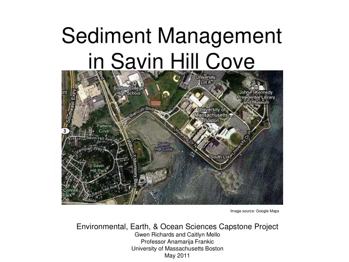
Sediment Management in Savin Hill Cove
Image source: Google Maps
Sediment Management in Savin Hill Cove Image source: Google Maps - - PowerPoint PPT Presentation
Sediment Management in Savin Hill Cove Image source: Google Maps Environmental, Earth, & Ocean Sciences Capstone Project Gwen Richards and Caitlyn Mello Professor Anamarija Frankic University of Massachusetts Boston May 2011 Our Project
Environmental, Earth, & Ocean Sciences Capstone Project
Gwen Richards and Caitlyn Mello Professor Anamarija Frankic University of Massachusetts Boston May 2011
Image source: Google Maps
Image source: www.neponset.org Image source: www.mass.gov/czm/coastguide/online/descriptions/dorchester_bay_quincy.htm
Image source: http://kevishere.files.wordpress.com/2010/10/umass-boston1.jpg Photo taken by Michiey (http://www.flickr.com/photos/michiey/)
High tide: Low tide:
Image Source: http://www.mwra.state.ma.us/annual/csoar/2004mwracsoar.pdf
Image Source: http://www.ozcoasts.org.au/conceptual_mods/threats/images/dredging.jpg
– Chris Sweeney Director of Marine Operations (UMB), Zehra Schneider Grahm Deputy Director of Environmental & Health Services Office
– History, Past dredging, UMB Master Plan
Image source: Umass Boston Digital Archives Image source: Umass Boston website Image source: Umass Boston Digital Archives
Image source: Great Ecology and Environments, Inc.
pollutants
biodiversity
sediment
Image Source: Virginia Coastal Zone Management
Rock sill together with Salt Marsh
seeded salt marshes
Image Source: National Transportation Enhancements Clearinghouse Image source: Greenspace Image Source: Quality Assurance for Nonpoint Source Best Management Practices
Bio-retention areas both large and small proposed as storm water runoff buffers along roadways and parking lots
pollution
/sediment from runoff
Image source: http://www.mvs.usace.army.mil/arec/basics.html Image source: Granite Environmental, Inc. Image Source: Nautic Expo
Silt Screens
Prevent sediment accumulation in Savin Hill Cove
Training Dams
Control water/sediment pathways
Pneumatic Barriers
Prevent sediment from settling in navigation channels
Illustrated by Caitlyn Mello
marshes
barriers
areas
Granite Environmental, Inc. (http://www.erosionpollution.com/)
Photo used: (http://www.silt-barriers.com/images/Tenerife_Type_3.jpg)
Great Ecology and Environments, Inc. (http://www.greatecologyandenvironments.com)P
Photo used: (http://www.greatecologyandenvironments.com/wp-content/uploads/2009/02/3_inspection.jpg )
Massachusetts Water Resources Authority: Combined Sewer Overflow Plan http://www.mwra.state.ma.us/annual/csoar/2004mwracsoar.pdf Nautic Expo (http://www.nauticexpo.com/prod/hydro-technik-la-beck/permanent-floating-oil-booms-for-harbor- compressed-air-systems-32661-199854.html)
Photo used: (http://img.nauticexpo.com/images_ne/photo-m2/permanent-floating-oil-boom-for-harbor-compressed-air-system-199854.jpg)
National Transportation Enhancements Clearinghouse (http://images.enhancements.org/1-Ped-Bike-Facilities/A- Green-Street92nd-AvePortland/3349071_8zrQp#186689573_PRYN7)
Photo used: (http://images.enhancements.org/1-Ped-Bike-Facilities/A-Green-Street92nd-AvePortland/3349071_8zrQp#186688734_EW2nC)
University of Massachusetts Boston website (http://www.umb.edu)
Photo used: (http://temp4.www.umb.edu/strategic_plan/)
University of Massachusetts Boston Digital Archives (http://www.lib.umb.edu/archives/digital/index.php)
Photos used: (http://www.lib.umb.edu/archives/digital/?p=collections/controlcard&id=2524) (http://www.lib.umb.edu/archives/digital/index.php?p=digitallibrary/digitalcontent&id=1561)
Virginia Coastal Zone Management (http://www.deq.virginia.gov/coastal/sf2008magclimatechange.html) Quality Assurance for Nonpoint Source Best Management Practices (http://www.lowimpactdevelopment.org/qapp/index.htm)
Photo used: (http://www.lowimpactdevelopment.org/qapp/bio_benefits.htm)