SLIDE 1
Global Flood Analysis and Forecasts Using Satellite Rainfall Coupled with Land Surface and Routing Models—Recent Results
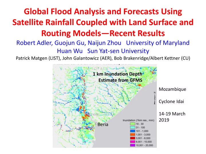
Robert Adler, Guojun Gu, Naijun Zhou University of Maryland Huan Wu Sun Yat-sen University
Patrick Matgen (LIST), John Galantowicz (AER), Bob Brakenridge/Albert Kettner (CU) Mozambique Cyclone Idai 14-19 March 2019 1 km Inundation Depth Estimate from GFMS Beria
SLIDE 2 Global Real-time Flood Calculations Using Satellite Rainfall and Hydrological Model
Global Flood Monitoring System (GFMS)
http://flood.umd.edu/ GPM Multi-satellite Rainfall (IMERG)
GPM rainfall into land surface and routing models for water depth and stream flow calculations compared to flood thresholds
Indus River basin Global Flood Detection
Time Histories at a Point
Additional Routing and Inundation Mapping at 1 km resolution
Flood Threshold
12 km/ 3 hr resolution
Land Surface Model Routing Model
Developed by Huan Wu (SYSU)
SLIDE 3 Global Flood Monitoring System (GFMS)
GFMS now uses NASA’s Global Precipitation Measurement (GPM) mission IMERG multi-satellite rainfall product in “real-time” system with flood thresholds values based on long-term retrospective calculations (flood.umd.edu) IMERG is used at 1/8th degree lat./long., 3-hour resolution as input to VIC land-surface model and routing at 12 and 1 km resolution Products include 1 km inundation/depth calculation Analyses are available at flood.umd.edu and various data are available for download Connected to GPM website, NASA Disasters Portal, Flood Observatory (U.
- f Colorado), Global Flood Partnership (GFP)
Focus here is on examples of recent events and potential for integration with other remote-sensing flood observations
SLIDE 4 AER FloodScan AER FloodScan
Mozambique Cyclone Idai March 2019
UMD GFMS SAR Numerous Remote Sensing- based flood products
SLIDE 5
X Beria
SLIDE 6
Cyclone Idai Just Before Landfall (14 March 2019)
Beria X Mozambique Indian Ocean
Satellite
SLIDE 7 3-Day Forecast Rain from 14 March (from NASA GEOS NWP model) 3-Day Satellite-based Rain from 14-17 March
Forecast Rain Before Cyclone Hit
NWP forecast peak totals were ~ 1000 mm, while peak satellite estimates (IMERG) were ~ 600 mm. Ground validation was missing/questionable.
X Beria X Beria
SLIDE 8 Forecast from 14 March for 17 March Nowcast using Satellite Rainfall for 17 March
Flood Forecasts from NWP Rain vs. Nowcast Using Satellite Rain
Flood Detection/Intensity (Depth) Forecast at coarse (12 km) resolution gives good warning
- f where flooding may occur both in Mozambique and
Zimbabwe, with less intensity due to difference in peak rain amounts Forecast Nowcast
X Beria X Beria
SLIDE 9
Mean Rainfall During March 4-21, 2019 IMERG (satellite) vs GPCC (gauges)
At least one gauge in each 1º grid Although validation (gauges) are missing/questionable, it appears IMERG underestimated, especially at high end.
SLIDE 10
Hurricane Florence (Carolinas, USA) Mean precipitation during September 13-18, 2018 IMERG vs CPC Gauge
PDF Matching At least one gauge in each 0.25º grid
SLIDE 11 15 March First Estimate of Inundation—from GFMS 17.5 S 21.0 S 33.0 E 37.0 E Timeline of Useful Inundation Maps
15 March--GFMS 1 km (calculation based on Satellite rainfall and land-surface/routing models— every 3 hrs.) 17 March—AER FloodScan (surface passive microwave signal disaggregated spatially by terrain, but obscured by rain [not cloud] 20 March—Synthetic Aperture Radar (SAR) published by UNOSAT from Sentinel-1 data 19-20 March.
Number of groups analyzing Sentinel and
Later—Optical (e.g., MODIS)
How to use these resources in an integrated fashion taking into account timelines and quality??
X Beria
SLIDE 12
19 March AER FloodScan GFMS 1 km Inundation Passive microwave surface signals relate to non- typical surface water, very high soil moisture at coarse (15 km) resolution. Fine-scale inundation uses coarse-scale fractional water and topography X Beria X Beria
SLIDE 13 SAR-based Inundation Maps
NASA/JPL UNOSAT LIST Luxembourg Flood Observatory
SLIDE 14
Mozambique Floods— Inundation/Water Depth from GFMS (Max 14-19 March 2019)
19-20 March
GFMS SAR
X BERIA X BERIA 50 km
SLIDE 15
GFMS and SAR (LIST) Inundation Comparison March 19, 2019
X BERIA
POD: 13% FAR: 21% CSI: 13%
SLIDE 16
March 19, 2019 March 20, 2019 March 20, 2019
Other Examples (with similar results)
SLIDE 17
Time Integrated Inundation from GFMS
Maximum Inundation from GFMS (14-19 March) vs. Max Inundation from SAR (LIST) Better agreement with SAR—Higher POD, but lower FAR
POD: 47% FAR: 57% CSI: 29%
SLIDE 18 Flood Threshold
Streamflow/Flood Estimates from RiverWatch (Flood Observatory) and GFMS
RiverWatch Uses surface microwave
related to streamflow Station # 260 19.39S, 34.51E Punge R. GFMS Streamflow Satellite rainfall into land surface/routing models
SLIDE 19 Real-time users need accurate information, quickly. Multiple sources are available, at different time and space resolutions (and different latencies) and with different positive qualities and limitations. With multiple sources, users need info. to be “easy to compare” or integrated.
Integrated Products
Individual products (e.g., inundation estimates) will continue to improve with better observations, algorithms and modeling—but there will always be limitations in accuracy, availability, etc. So, we also need to be working toward melding or integrating our multiple estimates into a “best” estimate. For inundation, one possible approach: Daily, model-based estimate as base, with optical and SAR products as additional options where/when
- available. All remapped and available as layers (if available); possible merger
- r best estimate as separate product.
A technical starting point is simple comparisons to understand strengths/weaknesses, with possible product approaches driven by user interests. Some ideas are being tested/applied at Flood Observatory This type of work needs programmatic integration too; a great place for leadership by certain funding agencies working together, but also “steering” by entities like the Global Flood Partnership (GFP) Mozambique Flood Example Next Steps?
SLIDE 20
SLIDE 21 Ramada Pearl Guangzhou
X
Zhujiang (Pearl) River Xijiang River
SLIDE 22
SLIDE 23
Criteria and assumption: (1) mass balance; (2) inundation only happens in floodplain across the river reach with a level water surface; (3) inundation process finishes within the same time interval as the routing model; (4) inundation buffer area doesn’t include the grid cells with higher river order.
GFMS Inundation Algorithm 1 km Streamflow
Overbank flooding Not inundated Inundated cell without expanding Non-inundated potential flooding Inundated cell
SLIDE 24
SLIDE 25
SLIDE 26