Real-time Weather and Stream Monitoring Sensors and Stations - - PowerPoint PPT Presentation

real time weather and stream monitoring sensors and
SMART_READER_LITE
LIVE PREVIEW

Real-time Weather and Stream Monitoring Sensors and Stations - - PowerPoint PPT Presentation

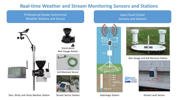
Real-time Weather and Stream Monitoring Sensors and Stations Professional Grade Commercial Iowa Flood Center Weather Stations and Sensor Sensors and Stations Stand-alone Rain Gauge Station Rain Gauge and Soil Moisture Station Soil Moisture


slide-1
SLIDE 1

Soil Moisture Sensor Rain Gauge and Soil Moisture Station Stream Sensor Station Stand-alone Rain Gauge Station Rain, Wind, and Temp Weather Station Hydrologic Station Stream Level Sensor

Real-time Weather and Stream Monitoring Sensors and Stations

Iowa Flood Center Sensors and Stations Professional Grade Commercial Weather Stations and Sensor

slide-2
SLIDE 2

Roadside Water Detection – Warning and Alerting Systems

Single or Multiple Flood-level Sensors can be Installed Fiber Optic and Ultrasonic Sensor Types also available

slide-3
SLIDE 3

Sensor Deployment Scenarios for Watersheds

Iowa Flood Center Recommendation: 1-Hydrologic/Weather Station and 8-Stream Level Sensors per watershed

slide-4
SLIDE 4

Data Platform and Information System Management

Cloud Server OR Local In-House Servers

Stations / Sensors Cellular or Wi-Fi Transmission Data Storage and Processing User Interface Internet Web or Mobile Applications

slide-5
SLIDE 5

Data Platform and Information System Management

Local Level Option:

Register Devices with NWS Citizen Weather Observer Program (CWOP)

State Level Option:

Develop Platform similar to Iowa Flood Center Information System

Regional Option:

Upper Mississippi Information System

  • Register stations / sensors with CWOP
  • Data is stored and managed by NWS
  • Data can be served through NWS local data

page

  • Alerting system can be established with NWS
  • Reporting time is hourly but could possibly be

decreased to 15 minutes.

  • Develop stand-alone platform for state

level coverage

  • Data can be stored and managed by state

agency

  • Data can be served through Google Maps

Interface

  • Alerting systems can be established
  • Reporting time is dependent on sensor

and reporting intervals can range from 5 – 15 minutes

  • Regional Level Platform – Iowa Flood Center and

National Science Foundation partnership

  • Manage and serve water-quality and quantity

data

  • Data Platform addresses big data needs of

several states and provides access to large data sets that are managed independently.

  • Data Partnership opportunity
  • Further details to be determined…
slide-6
SLIDE 6

Equipment and Data Service Cost Estimates

EQUIPMENT (2 Watersheds)

2 Weather Stations ($1,500 ea) 16 Sensor Level Stations ($1,500 ea)

$27,000

DATA SERVICE

Partnership with NWS - CWOP

FREE SERVICE

MAINTENANCE

Wi-Fi / Cellular Service Plan ($300/yr) Equipment maintenance ($1000/yr)

$1,300 / Year

Local Level Option:

Register Commercial Devices with NWS Citizen Weather Observer Program (CWOP)

State Level Option:

Deploy IFC stations/sensors and develop platform similar to Iowa Flood Center Information System

EQUIPMENT (2 Watersheds)

2 Hydrologic Stations ($9,400 ea) 16 Stream Level Sensors ($4,500 ea)

$90,800

DATA SERVICE

Basic Platform & Interface ($500K)

  • Adv. Platform w/Modeling ($1 – 2 mil)

$500K - $2 Million

MAINTENANCE

Scalable services based on data storage, processing, retrieval, and monthly usage

SCALABLE COSTS

Roadside Detection / Alerting System Option: EQUIPMENT (2 Watersheds)

2 Detection System ($4,200) 4 Warning Poles w/ Beacons ($4,400 ea)

$26,000

ALERTING SYSTEM

Web Activation and Cellular Service for Alert-Based System ($500 / system)

$1000 / Year

USGS PARTNERSHIP or UPPER MISSISSIPPI PARTNERSHIP To Be Determined…