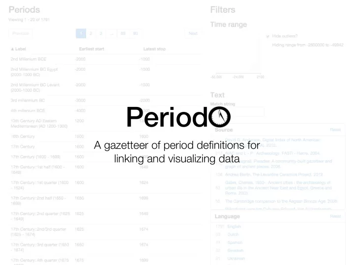
period
play

Period A gazetteer of period definitions for linking and - PowerPoint PPT Presentation

Period A gazetteer of period definitions for linking and visualizing data Goals Document definitions of historical period names, in a machine-friendly way Provide stable identifiers for period definitions so data curators can reference


  1. Period A gazetteer of period definitions for linking and visualizing data

  2. Goals • Document definitions of historical period names, in a machine-friendly way • Provide stable identifiers for period definitions so data curators can reference them unambiguously • Provide tools to find and compare period definitions and to to understand patterns of periodization

  3. Initial sources • Pleiades / Pelagios • ARIADNE network • Fasti Online • British Museum • ArcheoInf project • German Archaeological Institute • University of Oxford’s • Archaeology Data Service (UK) CLAROS project • English Heritage • UCLA Encyclopedia of Egyptology • Hypermedia Research Unit at the University of South Wales • Levantine Ceramics Project

  4. Data model To be included in the gazetteer, a definition must • give the period a name • impose some temporal bounds on the period • have some implicit or explicit association with a geographical region , and • have been formally or informally published in some citable source .

  5. Periods are concepts • skos:prefLabel is used for the name of the period exactly as given in the original source. • skos:altLabel is used for language-specific names of the period, assigned by PeriodO curators.

  6. Periods are concepts • skos:note is used for notes about the period definition that appeared in the original source. • skos:editorialNote is used for administrative or editorial notes added by the PeriodO curators.

  7. Temporal extent • skos:prefLabel is used to textually describe the interval exactly as given in the original source • time:hasDateTime Description is used to describe the interval in a more structured fashion

  8. Spatial extent • periodo:spatialCoverageDescription is used to textually describe the spatial extent exactly as given in the original source • dcterms:spatial is used to link a period definition to descriptions of locations in gazetteers

  9. Source

  10. The PeriodO client http://n2t.net/ark:/99152/p0

  11. Workflow

  12. Thanks! http://perio.do https://github.com/periodo @perio_do ryanshaw@unc.edu

  13. JSON-LD serialization

  14. JSON Patch

  15. Identifiers http://n2t.net/ark:/99152/p0rqpwq4prr name mapping authority hostport name name assigning authority number

Download Presentation
Download Policy: The content available on the website is offered to you 'AS IS' for your personal information and use only. It cannot be commercialized, licensed, or distributed on other websites without prior consent from the author. To download a presentation, simply click this link. If you encounter any difficulties during the download process, it's possible that the publisher has removed the file from their server.

Recommend


More recommend