NORTH KIRKLAND FIRE STATION SITING ANALYSIS CITY OF KIRKLAND - - - PowerPoint PPT Presentation

north kirkland fire station
SMART_READER_LITE
LIVE PREVIEW

NORTH KIRKLAND FIRE STATION SITING ANALYSIS CITY OF KIRKLAND - - - PowerPoint PPT Presentation

NORTH KIRKLAND FIRE STATION SITING ANALYSIS CITY OF KIRKLAND - November 18 th , 2014 NORTH KIRKLAND FIRE STATION SITING ANALYSIS Goal of Tonights Presentation To Determine 1 or 2 Preferred Sites for Further Study GOAL f i r e s t a t


slide-1
SLIDE 1

NORTH KIRKLAND FIRE STATION SITING ANALYSIS

CITY OF KIRKLAND - November 18th, 2014

slide-2
SLIDE 2

GOAL

f i r e s t a t i o n s i t i n g a n a l y s i s

Goal of Tonight’s Presentation

  • To Determine 1 or 2 Preferred Sites for Further Study

NORTH KIRKLAND FIRE STATION SITING ANALYSIS

slide-3
SLIDE 3

PROCESS

f i r e s t a t i o n s i t i n g a n a l y s i s

SITE # ACRES OWNER ADDRESS PHONE ZONING PARCEL # NOTES 2 1.03 Desert Dogs LLC NE 141st St RMA 3.6 3579800549 Vacant, Considerable topo 3 1.5+/- Presbyterian Church + Adjacent 7718 NE 141st RSA 4 2426049077 Property east of stream and probably uincluding two houses. Stream setback unknown at this
  • time. Sight lines OK
4 0.80 76th Pl NE Assembled 4 Houses 7807 NE 141st Pl RSA 6 6599500210, 200, 220, 230 Four houses. Drive through possible with access on NE 141st Place. Sight lines OK 5 1.15+ 81st Pl to 82nd Pl Assembled 6 Houses 14102 81st Pl NE RSA 6 1112700010 Six houses assembled street to street. Sight lines OK. Close to existing station site 6 3.00 Buckner 8421 NE 142nd RSA 6 6675500230 Large lot with a significant low wetland or lake. Would be a station / park. Close to existing station 7 1.10 Expanded Existing Station 8411 NE 141st St. Facing 84th Ave NE RSA 6 6675500210 Three assembled houses (or fewer) Well located. Good access and topo 8 Placeholder 9 Placeholder 10 1.5 +/- LW School District LDS Church 7910 132nd St and adjacent RSA 4 2426049034 Excess school property. Not surplussed. Lease only. Considerable topo and land loss 11 1.74 +/- Check, Walker,
  • Stump. Large
lots S of Sandburg 12637 84th Ave NE RSA 8 3840700460 Assemble 2 houses. Large lots S of Sandburg Elementary. Reasonably flat. Kirkland land use permit posted 12 1.28 + O'Dell - Possibly with adjacent church property
  • n 84th
8527NE 127th St RSA 4 3026059283 House set back behind Vianney Church's N driveway. Would require access reconfiguration. Ample land 13 0.70 Thompson 12520 84th Ave NE RSA 8 3026059008 Lot fronting 84th in front of the S driveway to Vianney Church. Possibility of additional parking behind if agreement with church 14 .86+ Roach, Richardson 8205 NE 128th St RSA 6 3840700502, 507 House across from Sandburg Elementary with vacant lot behind. 1.7 Ac if assemble the properties east to 83rd Ct 15 6+/- Kosalos, Van Engle Juanita Dr N of NE 133rd Pl RSA 4 2426049033, 9032, 9152, Low undeveloped property east of Juanita Dr. Stream runs from the NE to SW where it enters a culvert (obscured visual observation) 16 0.75 Lees 12634 Juanita Dr RSA 8 3840700659, 0720 Property N of Radke. Juanita Drive. Fast moving traffic. Sight lines OK 17 1.2 + Radke 12622 Juanita Dr RSA 8 3840700665, 0735, 0658 Various possibilities with Radke properties. Fast moving traffic. Sight lines OK 18 1.56 Sears 12831 Juanita Dr RSA 4 3840700290 Low property below street grade. Fast moving traffic. Sight lines OK 19 3.5+/- Radke 12432 Juanita Dr RSA 8 3840700755, 0758, 0685 Fast moving traffic. Sight lines OK 20 1.53 Seawest Investment LLC 13022084th Ave NE Rsa 4 3026059189, 9060, 9130 King County land use sign (old) Under contract to a developer according to realtor. Across from Sandburg Elementary 21 0.58 Supervalu 9826NE 132nd St. (Albertsons) BC 1 192605 9157 Albertson's sub-lease for an additional 16 years. This site will require additional land. Topo is a consideration 22 1.39 Juanita Community Church 10007 NE 132nd St PR 3.6(2) 292605 9127 Church would move if there were an equal or better alternative. Includes church office house on
  • corner. Topo is a consideration
  • The study evaluates

consolidated single and dual station options

  • A long list of 22 sites were

identified in the NW Part of the City

slide-4
SLIDE 4

PROCESS

  • Working with the

Station Siting Steering Team, 3 sites were identified for detailed study

  • Selected sites

anticipated the replacement of 24 & 25 with a single station

f i r e s t a t i o n s i t i n g a n a l y s i s

slide-5
SLIDE 5

PROCESS

  • Based on the

Standard of Coverage and Deployment Plan (SOCDP), 2 sites added

  • SOCDP suggests

a dual station model keeping station 25 open

f i r e s t a t i o n s i t i n g a n a l y s i s

slide-6
SLIDE 6

PROCESS

Council Study Session – 08/06/14

  • Council supports

dual station model w/ station 25 open

  • 3 sites (11,12, 20)

eliminated

  • 4 sites added for

study(23,24,25,26)

  • Sites renamed

A -F

f i r e s t a t i o n s i t i n g a n a l y s i s

KEY

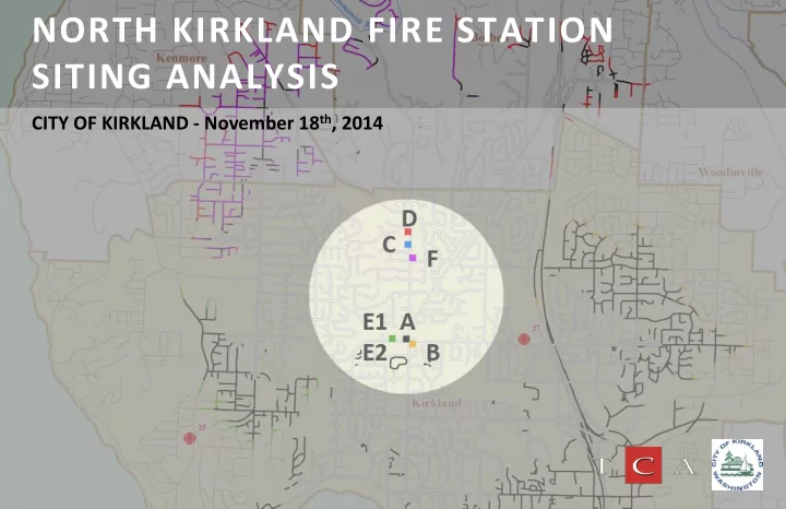
21 = A 22 = B 23 = C 24 = D 25 = E1, E2 26 = F

slide-7
SLIDE 7

PROCESS

  • Site Locations

f i r e s t a t i o n s i t i n g a n a l y s i s

Table 1 – Site Locations

SITE ID ADDRESS AREA (ACRES) A Gas Station 9950 NE 132ND ST 0.71 B Church 10007 NE 132ND ST 1.40 C Residential 1 14207 100TH AVE NE 2.39 D Residential 2 14237 & 14239 100TH Ave NE 1.09 E1 Rite Aid Partial 9820 NE 132nd ST 1.09 E2 Rite Aid Full 9820 NE 132nd ST 2.52 F Public 14000 block of 100th Ave NE 1.27

Original New

slide-8
SLIDE 8

4 MIN RESPONSE MAP

f i r e s t a t i o n s i t i n g a n a l y s i s

SITE A Gas Station

slide-9
SLIDE 9

4 MIN RESPONSE MAP

f i r e s t a t i o n s i t i n g a n a l y s i s

SITE B Church

slide-10
SLIDE 10

4 MIN RESPONSE MAP

f i r e s t a t i o n s i t i n g a n a l y s i s

SITE C Residential 1

slide-11
SLIDE 11

4 MIN RESPONSE MAP

f i r e s t a t i o n s i t i n g a n a l y s i s

SITE D Residential 2

slide-12
SLIDE 12

4 MIN RESPONSE MAP

f i r e s t a t i o n s i t i n g a n a l y s i s

SITE E1 & E2 Rite Aid

slide-13
SLIDE 13

4 MIN RESPONSE MAP

f i r e s t a t i o n s i t i n g a n a l y s i s

SITE F Public

slide-14
SLIDE 14

4 MIN RESPONSE MAP

f i r e s t a t i o n s i t i n g a n a l y s i s

Response Time Comparisons

  • f Potential

Sites

slide-15
SLIDE 15

PROCESS

Site A – Gas Station

f i r e s t a t i o n s i t i n g a n a l y s i s

slide-16
SLIDE 16

PROCESS

Site B - Church

f i r e s t a t i o n s i t i n g a n a l y s i s

slide-17
SLIDE 17

PROCESS

f i r e s t a t i o n s i t i n g a n a l y s i s

Site C – Residential 1

slide-18
SLIDE 18

PROCESS

f i r e s t a t i o n s i t i n g a n a l y s i s

Site D – Residential 2

slide-19
SLIDE 19

PROCESS

f i r e s t a t i o n s i t i n g a n a l y s i s

Site E1 – Rite Aid, Partial

slide-20
SLIDE 20

PROCESS

f i r e s t a t i o n s i t i n g a n a l y s i s

Site E2 – Rite Aid, Full

slide-21
SLIDE 21

PROCESS

f i r e s t a t i o n s i t i n g a n a l y s i s

Site F - Public

slide-22
SLIDE 22

COSTS

Land, Site Development & Building Costs (at 8,406 sq. ft)

f i r e s t a t i o n s i t i n g a n a l y s i s

Inflated to 2015 osts +17%

slide-23
SLIDE 23

COSTS

Land, Site Development & Building Costs (at 8,406 sq. ft)

f i r e s t a t i o n s i t i n g a n a l y s i s

slide-24
SLIDE 24

COSTS

Land, Site Development & Building Costs (at different program requirements)

f i r e s t a t i o n s i t i n g a n a l y s i s

slide-25
SLIDE 25

FINANCE

Financing Options

f i r e s t a t i o n s i t i n g a n a l y s i s

  • Current cost estimates for new station range from

$7.5 - 11.9 million and do not include costs of any renovation to Station 25

  • Current funding available:

Bond Proceeds from Fire District 41 4,000,000 $ Remaining Cash from FD 41 1,200,000 Recommended 15-16 Budget Cash Set Aside 3,000,000 Total Identified Funding 8,200,000 $

slide-26
SLIDE 26

FINANCE

Financing Options

f i r e s t a t i o n s i t i n g a n a l y s i s

  • Other potential sources:
  • General Capital Contingency
  • Real Estate Excise Tax
  • Councilmanic (non-voted) bonds
  • Voted bonds (excess levy requiring 60%)
  • Voted levy lid lift (requiring 50% +1)
slide-27
SLIDE 27

INTERLOCAL AGREEMENT

f i r e s t a t i o n s i t i n g a n a l y s i s

  • Current Interlocal Agreement provides that:
  • Proceeds from sale of stations 24 and 25 must be used to pay down
  • utstanding District debt
  • If the City retains either station, the City is required to apply an amount

equal to the fair market value to pay down outstanding District debt

  • Fire District 41 Bond Counsel working to define a process to clarify

intent:

  • Joint public hearing of the former Fire District 41 Commissioners and the

Kirkland City Council

  • Agreement to modify the provisions
  • Notice to bond holder
slide-28
SLIDE 28

City Council Direction Needed

  • Site Selection
  • Direction to proceed with negotiations on preferred site(s)
  • Future City Council Decisions
  • Select programmatic building elements
  • Station sizing
  • Station budget

f i r e s t a t i o n s i t i n g a n a l y s i s

DIRECTION