nav app
play

Nav App New features NavLink for MAC is a full featured chart and - PowerPoint PPT Presentation

NavLink for Mac Nav App New features NavLink for MAC is a full featured chart and nav application for Apple MacBook PCs. Its available with detailed UK or US charting included utilising UKHO and NOAA Government data for the best in


  1. NavLink for Mac Nav App New features 
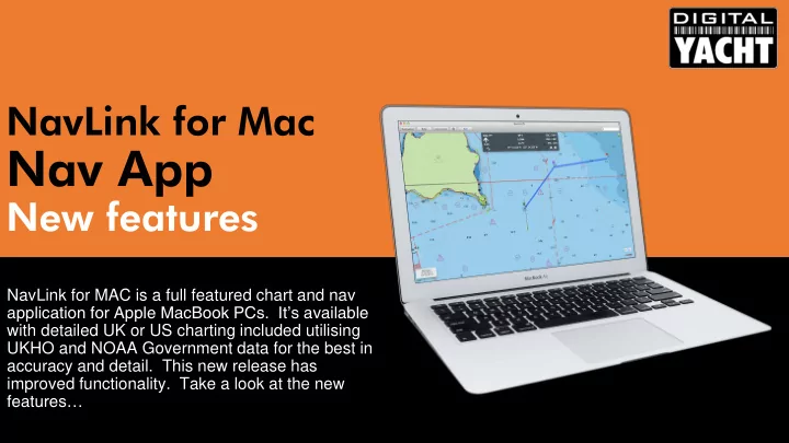
NavLink for MAC is a full featured chart and nav application for Apple MacBook PCs. It’s available with detailed UK or US charting included utilising UKHO and NOAA Government data for the best in accuracy and detail. This new release has improved functionality. Take a look at the new features…

  2. NavLink for MAC Navigation App Key features: • Converts an Apple MacBook into a full featured electronic chart plotter • Waypoint, route and track capability • Share routes with other users and with NavLink iPad/iPhone app • AIS target overlay from live AIS feed or internet data • Tide and weather capability • Connect via USB or wireless to the boat’s GPS and AIS systems – compatible with Digital yacht NMEA servers and USB AIS devices • UK or US charting built in • European charting options coming soon

  3. Integrating NavLink Option: Connect Via USB Utilise a Digital Yacht NMEA- USB cable to integrate the MacBook via a wired connection. This device has a well proven driver for all versions of MAC OS and can support a single channel of NMEA data at 4800 or 38400 baud. If you have multiple inputs (eg GPS and AIS) utilise the Digital Yacht MUX100 2 channel NMEA multiplexer

  4. Integrating NavLink Option: Connect Via WiFi This is the preferred solution as it allows a cable free and easy installation. Utilise a Digital Yacht NMEA-WiFi device such as the WLN10, iAIS, AIT3000 or WLN10 to integrate the MacBook into the boat’s NMEA system via a simple on board wifi connection. Connect the MacBook to the wifi hotspot created by the server and get real time data streamed across to the MacBook

  5. New Features Walk through the new features

  6. NavLink now supports an improved AIS presentation. Note how targets and now scaled and colour coded according to type. Seeing the size of the target makes anti collision calculations much easier as you can see if you’ll pass ahead or astern of the vessel Note the anchor symbol for moored vessels

  7. Vessel scaling is shown very effectively here with ships lying at the discharge terminal in Southampton Water

  8. AIS and realtime GPS data from the AIS transponder can be connected to NavLink using a wireless connection. Add wireless connectivity utilising any of Digital Yacht’s NMEA to Wireless servers or utilise the new AIT3000 Class B transponder with built in wireless. AIS/GPS data can also be sent via USB utilising Digital Yacht’s USB -NMEA adaptor

  9. NavLink now also supports an internet feed of AIS data. This relies upon an internet data connection but allows you to see vessels away from your current location or while using NavLink for planning when ashore Internet AIS can be enabled and disabled as required but it is not recommended for realtime navigation – instead connect to your onboard AIS and GPS systems using Digital Yacht NMEA to wifi servers

  10. Here we see Red Falcon heading down the Solent. Note the colour coded ferry target and scaled vessel size plus heading line with name shown (optional) on chart Charts can be zoomed using these keys or utilise the track pad for pinch to zoom functionality. Pan the chart using the trackpad for the easiest and most intuitive operation of any chart plotter today

  11. Click on any point or target and get further information

  12. Click again for further drill down data. If an internet connection is available, NavLink will search the MMSI database for a vessel picture and include this in the drill down information

  13. Drill down is also available for navaids and marks. Simply click on the buoy or light to get further information including a graphic indication of light sequence too

  14. Build a route with one click simplicity. Once active you’ll get a dynamic navigation bar showing waypoint bearing and distance plus ETA and VMG too Even when you are Your current navigating an position and track active route you are updated on the can pan around detailed charts too the chart and drill down on AIS Share routes too! targets and navaid information

  15. Click on any point for a localised weather prediction including wind, temp, wave height and period, visibility and humidity

  16. Get Na NavLin ink k UK or Na NavLin ink k US S dir irec ect t from the MAC Ap App St Store

Download Presentation
Download Policy: The content available on the website is offered to you 'AS IS' for your personal information and use only. It cannot be commercialized, licensed, or distributed on other websites without prior consent from the author. To download a presentation, simply click this link. If you encounter any difficulties during the download process, it's possible that the publisher has removed the file from their server.

Recommend


More recommend