mobile communications
play

Mobile Communications 1965 first commercial geostationary satellite - PowerPoint PPT Presentation

History of satellite communication 1945 Arthur C. Clarke publishes an essay about Extra Terrestrial Relays 1957 first satellite SPUTNIK 1960 first reflecting communication satellite ECHO 1963 first geostationary satellite SYNCOM


  1. History of satellite communication 1945 Arthur C. Clarke publishes an essay about „Extra Terrestrial Relays“ 1957 first satellite SPUTNIK 1960 first reflecting communication satellite ECHO 1963 first geostationary satellite SYNCOM Mobile Communications 1965 first commercial geostationary satellite Satellit „Early Bird“ Chapter 5: Satellite Systems (INTELSAT I): 240 duplex telephone channels or 1 TV channel, 1.5 years lifetime 1976 three MARISAT satellites for maritime communication  History  LEO, MEO, GEO 1982 first mobile satellite telephone system INMARSAT-A  Basics  Examples 1988 first satellite system for mobile phones and data  Orbits  Handover, Routing communication INMARSAT-C 1993 first digital satellite telephone system 1998 global satellite systems for small mobile phones Mobile Communications Satellite Systems 1 Mobile Communications Satellite Systems 2 Applications 
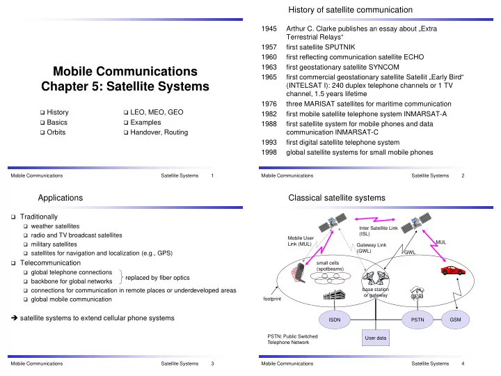
Classical satellite systems  Traditionally  weather satellites Inter Satellite Link (ISL)  radio and TV broadcast satellites Mobile User MUL  military satellites Link (MUL) Gateway Link (GWL)  satellites for navigation and localization (e.g., GPS) GWL  Telecommunication small cells (spotbeams)  global telephone connections replaced by fiber optics  backbone for global networks base station  connections for communication in remote places or underdeveloped areas or gateway  global mobile communication footprint  satellite systems to extend cellular phone systems ISDN PSTN GSM PSTN: Public Switched User data Telephone Network Mobile Communications Satellite Systems 3 Mobile Communications Satellite Systems 4

  2. Basics Satellite period and orbits Satellites in circular orbits  attractive force F g = m g (R/r)² 24 satellite  centrifugal force F c = m r ω ² velocity [ x1000 km/h] period [h]  m: mass of the satellite 20  R: radius of the earth (R = 6370 km)  r: distance to the center of the earth 16  g: acceleration of gravity (g = 9.81 m/s²)  ω : angular velocity ( ω = 2 π f, f: rotation frequency) 12 Stable orbit 8  F g = F c 2 4 gR synchronous distance = r 35,786 km 3 π 2 ( 2 f ) 40 x10 6 m 10 20 30 radius Mobile Communications Satellite Systems 5 Mobile Communications Satellite Systems 6 Basics Inclination plane of satellite orbit  elliptical or circular orbits  complete rotation time depends on distance satellite-earth  inclination: angle between orbit and equator satellite orbit  elevation: angle between satellite and horizon  LOS (Line of Sight) to the satellite necessary for connection perigee  high elevation needed, less absorption due to e.g. buildings δ  Uplink: connection base station - satellite  Downlink: connection satellite - base station inclination δ  typically separated frequencies for uplink and downlink  transponder used for sending/receiving and shifting of frequencies  transparent transponder: only shift of frequencies equatorial plane  regenerative transponder: additionally signal regeneration Mobile Communications Satellite Systems 7 Mobile Communications Satellite Systems 8

  3. Elevation Link budget of satellites Parameters like attenuation or received power determined by four parameters: Elevation:  sending power L: Loss angle ε between center of satellite beam f: carrier frequency and surface  gain of sending antenna r: distance c: speed of light  distance between sender π 2   and receiver 4 r f =   L  gain of receiving antenna   c Problems  varying strength of received signal due to multipath propagation  interruptions due to shadowing of signal (no LOS) minimal elevation: ε Possible solutions elevation needed at least to communicate with the satellite  Link Margin to eliminate variations in signal strength  satellite diversity (usage of several visible satellites at the same time) helps to use less sending power Mobile Communications Satellite Systems 9 Mobile Communications Satellite Systems 10 Atmospheric attenuation Orbits I Attenuation of Four different types of satellite orbits can be identified depending Example: satellite systems at 4-6 GHz the signal in % on the shape and diameter of the orbit: 50  GEO: geostationary orbit, ca. 36000 km above earth surface  LEO (Low Earth Orbit): ca. 500 - 1500 km 40 rain absorption  MEO (Medium Earth Orbit) or ICO (Intermediate Circular Orbit): ca. 6000 - 20000 km 30  HEO (Highly Elliptical Orbit) elliptical orbits fog absorption ε 20 10 atmospheric absorption 5° 10° 20° 30° 40° 50° elevation of the satellite Mobile Communications Satellite Systems 11 Mobile Communications Satellite Systems 12

  4. Orbits II LEO systems Orbit ca. 500 - 1500 km above earth surface GEO (Inmarsat, Thuraya)  visibility of a satellite ca. 10 - 40 minutes HEO MEO (ICO, GPS)  global radio coverage possible LEO inner and outer Van  latency comparable with terrestrial long distance (Globalstar, Allen belts connections, ca. 5 - 10 ms Irdium)  smaller footprints, better frequency reuse earth  but now handover necessary from one satellite to another 1000  many satellites necessary for global coverage 10000  more complex systems due to moving satellites Van-Allen-Belts: 35768 km ionized particles Examples: 2000 - 6000 km and  Iridium (start 1998, 66 satellites) 15000 - 30000 km  Globalstar (start 2000, 48 satellites) above earth surface Mobile Communications Satellite Systems 13 Mobile Communications Satellite Systems 14 MEO systems MEO systems: GPS (Global Positioning System) Orbit ca. 5000 - 12000 km above earth surface Basic concept of GPS comparison with LEO systems:  GPS receiver calculates its position (latitude, longitude, and altitude) by precisely timing the signals sent by GPS satellites high above the Earth  slower moving satellites  Each satellite continually transmits messages that include  less satellites needed  the time the message was transmitted  simpler system design  precise orbital information  for many connections no hand-over needed  the general system health and rough orbits of all GPS satellites  higher latency, ca. 70 - 80 ms  higher sending power needed  Receiver uses the received messages to determine the transit time of  special antennas for small footprints needed each message and computes the distance to each satellite  Trilateration Example:  Due to errors (inprecise clocks), not three but four or more satellites are used for calculations  ICO (Intermediate Circular Orbit, Inmarsat)  GPS, GALILEO Position useful in mobil communications for “Location based services”  Accuracy: „some meter“ with Wide Area Augmentation System WAAS Adopted from Wikipedia Mobile Communications Satellite Systems 15 Mobile Communications Satellite Systems 16

  5. MEO systems: GPS (Global Positioning System) MEO systems: GPS (Global Positioning System) Structure: three major segments  Space segment (SS) space segment (SS)  orbiting GPS satellites, or Space Vehicles (SV) 1.  24 SVs: six planes with four satellites each (plus some extra)  orbiting GPS satellites, or Space Vehicles (SV)  approximately 55° inclination  orbits are arranged such that >= 6 satellites are always within LOS control segment (CS) 2.  four satellites are not evenly spaced (90 degrees) within each orbit,  master control station (MCS), but 30, 105, 120, and 105 degrees  alternate master control station,  rotation time approx. 12 hours  four dedicated ground antennas and  orbit 20200 km  six dedicated monitor stations  ~ 9 satellites are visible from any point on ground at any one time user segment (U.S.) 3.  user devices US Air Force develops, maintains, and operates space & ctrl segments Adopted from Wikipedia Mobile Communications Satellite Systems 17 Mobile Communications Satellite Systems 18 MEO systems: GPS (Global Positioning System) MEO systems: GPS (Global Positioning System) Ground-Track (sub satellite path) of the Satellite GPS BIIR-07 (PRN 18) Position of the monitor stations and the master control station (Earthmap:NASA; http://visibleearth.nasa.gov/) of 18.10.2001, 00:00 h •  “master control station” (Schriever AFB) to 19.10.2001, 00:00 h •  plus additional monitoring stations for monitoring the satellites  every satellite can be seen from at least two monitor stations orbit time is slightly shifted (about 4 minutes) in 24 h • 21:30 zone of sight Mobile Communications Satellite Systems 19 Mobile Communications Satellite Systems 20

Download Presentation
Download Policy: The content available on the website is offered to you 'AS IS' for your personal information and use only. It cannot be commercialized, licensed, or distributed on other websites without prior consent from the author. To download a presentation, simply click this link. If you encounter any difficulties during the download process, it's possible that the publisher has removed the file from their server.

Recommend


More recommend