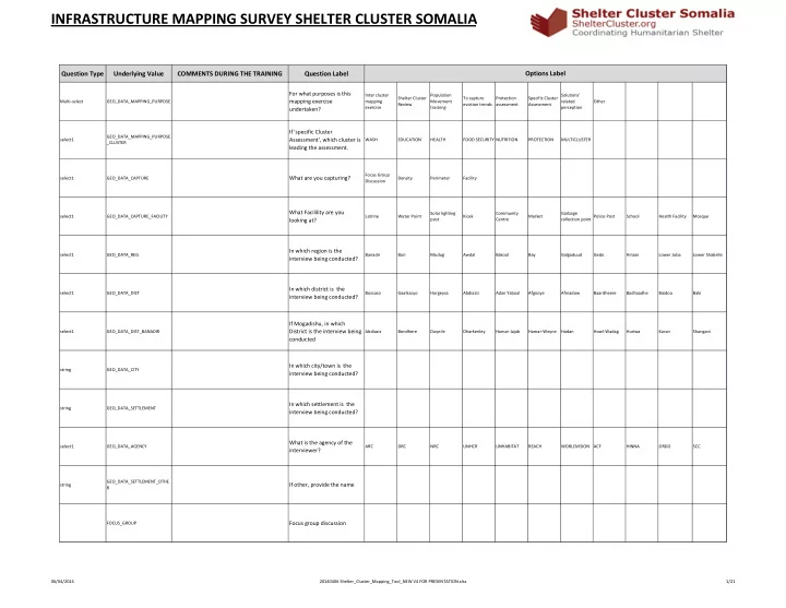

INFRASTRUCTURE MAPPING SURVEY SHELTER CLUSTER SOMALIA
Question Type Underlying Value COMMENTS DURING THE TRAINING Question Label
Multi-select GEO_DATA_MAPPING_PURPOSE
For what purposes is this mapping exercise undertaken?
Inter cluster mapping exercise Shelter Cluster Review Population Movement tracking To capture eviction trends Protection assessment Specific Cluster Assessment Solutions' related perception Other select1 GEO_DATA_MAPPING_PURPOSE _CLUSTER
If 'specific Cluster Assessment', which cluster is leading the assessment.
WASH EDUCATION HEALTH FOOD SECURITY NUTRITION PROTECTION MULTICLUSTER select1 GEO_DATA_CAPTURE
What are you capturing?
Focus Group Discussion Density Perimeter Facility select1 GEO_DATA_CAPTURE_FACILITY
What Facilility are you looking at?
Latrine Water Point Solar lighting post Kiosk Community Centre Market Garbage collection point Police Post School Health Facility Mosque select1 GEO_DATA_REG
In which region is the interview being conducted?
Banadir Bari Mudug Awdal Bakool Bay Galgaduud Gedo Hiraan Lower Juba Lower Shabelle select1 GEO_DATA_DIST
In which district is the interview being conducted?
Bossaso Gaalkacyo Hargeysa Abdiaziz Adan Yabaal Afgooye Afmadow Baardheere Badhaadhe Baidoa Baki select1 GEO_DATA_DIST_BANADIR
If Mogadishu, in which District is the interview being conducted
Abdiaziz Bondhere Daynile Dharkenley Hamar-Jajab Hamar-Weyne Hodan Howl-Wadag Huriwa Karan Shangani string GEO_DATA_CITY
In which city/town is the interview being conducted?
string GEO_DATA_SETTLEMENT
In which settlement is the interview being conducted?
select1 GEO_DATA_AGENCY
What is the agency of the interviewer?
ARC DRC NRC UNHCR UNHABITAT REACH WORLDVISION ACF HINNA ORDO SCC string GEO_DATA_SETTLEMENT_OTHE R
If other, provide the name
FOCUS_GROUP
Focus group discussion
Options Label
06/04/2014 20140406 Shelter_Cluster_Mapping_Tool_NEW V4 FOR PRESENTATION.xlsx 1/21