SLIDE 3 W 22 Main Street: The
building was constructed in 1886 and was used by Edwin C. Swift as a firm distributing papers and products used in packag- ing meat and fowl. Located in the center of Holyoke's meat and produce market and also near the mills, the firm was a successful business serving the community and local "meat wagons"
- n a daily basis. Forced to
expand its product market with the demise of the practice of buying meat
- n a daily basis, Swift (and
later Quirk) became known for developing three types of toilet paper.
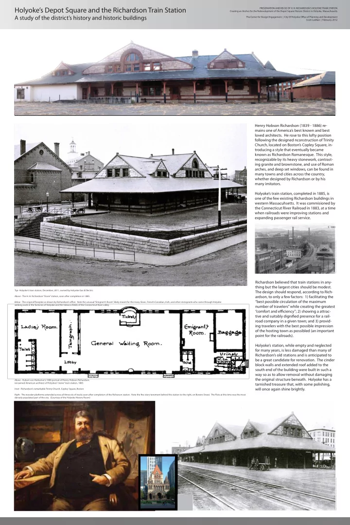
Holyoke’s Depot Square and the Richardson Train Station
A study of the district’s history and historic buildings
T 1 Main Street: The Parson Block was built for the Parsons Paper
Company for additional office space sometime before 1877. The build- ing became known as the Flatiron Building, reportedly for its unusual footprint (the famous Flatiron Building in New York City, with a similar footprint, was not built until 1902). Located at the corner of Main, Race, and Canal Streets on a site that narrows to a point, the four story brick building had handsome brickwork and stone lintels and was designed in a commercial classical style. The lot’s sharp corner is softened by the building’s rounded, bullnosed promontory, with the regular window pattern continuing across its face to make clear that the inside program continues within the unusual shape of the building. The ground floor tenant was for many years a drugstore, first as Balls’ Drugstore and then as Bardwell’s Drugstore. The building was taken down by the late 1960s.
U 2-6 Main Street: The Second Baptist Church of Holyoke first occu-
pied this location with a large building constructed sometime after the parish was organized in 1856 and before 1857, when the church is shown in a map. The church stood until the late 1880s, when it was demolished for unknown reasons. By 1884 a very narrow building, then known as the Norris House Hotel, had been built on a thin lot squeezed between the church and Mosher Street. With a façade only two windows wide, the building had only eight rooms, but it had the sudden advantage of being the closest hotel to the new Richardson train station when it opened in 1885. By the mid 1890s the hotel had been rebuilt with 42 rooms; it is unclear whether the original two-window wide building was expanded upon or simply replaced with the larger struc-
- ture. This building, renamed the Hotel Monat in the early 20th century,
stood until the late 20th century.
V 12-18 Main Street: The
North end of Main Street was densely built up by1877, as shown in a bird's-eye view of that year, but parts of it were rebuilt in subsequent periods of
buildings were probably built for Chase and Cooledge, a mill supply firm known to have moved to this location before
been founded in 1878 by Henry M. Cooledge, who later formed a partnership with John E. Chase. Mill supply and machine shop businesses were obviously an important component
dominated economy. The two that comprise 12-18 Main Street were
- riginally both four story
- structures. 16-18 had lost
all of its historic character, but 12-14 retained its 1880's character. Typical elliptical-arched window heads on the second and third floors, round arched window on the top floor, and a corbelled brick cornice.
X 24 Main Street: In 1884
the four story commercial building was erected for George Nightingale, a paper stock dealer. Architecturally, the struc- ture is very similar to those in the commercial district
This storefront housed Morris & Company in the early 20th century, as can be seen in a photograph to the lower left.
Y 31 Main Street: In 1905 a new marble Post Office building opened on
Main Street to replace the one that had been in the Holyoke House since 1853, having moved there from its location in the first passenger train depot. The advent of parcel post, however, rendered the new post
- ffice too small for its purpose soon after opening. The post office,
however, stayed in this building until 1935, when a new post office
- pened on Dwight Street between Chestnut and Elm Streets. The 1905
Post Office was torn down in 1949.
Z 324-344 Dwight Street: This building on the south west corner of
Dwight and main streets resumed to have been built sometime in the
- 1860s. It was home to the Hadley Falls National Bank from the time of
its construction to at least 1911. The bank had been organized in 1851 as the state bank. In 1865 the Hadley Falls Bank became a national
- bank. The building was designed in the commercial Romanesque style
popular with post-Civil War Victorians. A white belt course ran across each façades between the elliptical window arches made of alternating colored stone. The building was taken down sometime after 1984.
MAIN STREET BETWEEN CANAL AND DWIGHT STREETS MAIN STREET BETWEEN CANAL AND DWIGHT STREETS 1911 MAP OF DEPOT SQUARE AREA A record of a few of the historic buildings that have been lost in the Depot Square area
Many more buildings have been lost than are recorded here, particularly along the Main Street across from the
- riginal passenger rail depot at Depot Square. Preservation and reuse allow the city to retain its historic and
architecturally important buildings while providing a framework for future development.
Parsons Block, aka Flatiron Building (Courtesy of the Holyoke History Room) The intersection of Main, Race, Canal, and Mosher Streets, with the Parsons Block on the right, the Hotel Monat on the left, and Holy Rosary Church in the distance (Courtesy of the Holyoke History Room) The northern end of Main Street, with the Hotel Monat in the distance(Courtesy of the Holyoke History Room) Morris & Company employees and equipment at their shop at 24 Main Street (Courtesy of the Holyoke History Room)
SOUTHWEST CORNER OF DWIGHT AND MAIN STREETS
PRESERVATION AND REUSE OF H. H. RICHARDSON’S HOLYOKE TRAIN STATION Creating an Anchor for the Redevelopment of the Depot Square Historic District in Holyoke, Massachusetts The Center for Design Engagement | City Of Holyoke Office of Planning and Development Scott Laidlaw | February, 2012
Property of the Archives of the Holyoke History Room of the Holyoke Public Library Property of the Archives of the Holyoke History Room of the Holyoke Public Library Property of the Archives of the Holyoke History Room of the Holyoke Public Library
LOST HOLYOKE
- B. Garcelon, Holyoke Planning Board, Massachusetts Historical
Commission Application, 1978 Judith Jacobs, Holyoke Planning Board, Massachusetts Historical Commission Application, 1978 Nora Pat Small, Preservation Consultant, Massachusetts Historical Commission Application, 1984 Noah Reibel, “Historical Commission hopes to stop Hotel Jess demolition” The Sun, April 19-25, 2000, p. 7
1911 Richards & Company Map of Holyoke - Building indexed by letter (red for surviving buildings, blue for demolished buildings
Property of the Archives of the Holyoke History Room of the Holyoke Public Library Property of the Archives of the Holyoke History Room of the Holyoke Public Library Property of the Archives of the Holyoke History Room of the Holyoke Public Library Property of the Archives of the Holyoke History Room of the Holyoke Public Library Property of the Archives of the Holyoke History Room of the Holyoke Public Library Property of the Archives of the Holyoke History Room of the Holyoke Public Library Property of the Archives of the Holyoke History Room of the Holyoke Public Library Property of the Archives of the Holyoke History Room of the Holyoke Public Library Property of the Archives of the Holyoke History Room of the Holyoke Public Library Property of the Archives of the Holyoke History Room of the Holyoke Public Library Property of the Archives of the Holyoke History Room of the Holyoke Public Library Property of the Archives of the Holyoke History Room of the Holyoke Public Library Property of the Archives of the Holyoke History Room of the Holyoke Public Library Property of the Archives of the Holyoke History Room of the Holyoke Public Library