SLIDE 1 Environment and Natural Resources Trust Fund 2012-2013 Request for Proposals (RFP) Project Title:
Total Project Budget: $ Proposed Project Time Period for the Funding Requested: Other Non-State Funds: $ Name: Sponsoring Organization: Address: Telephone Number: Email Web Address County Name: City / Township: Region: Summary: Location
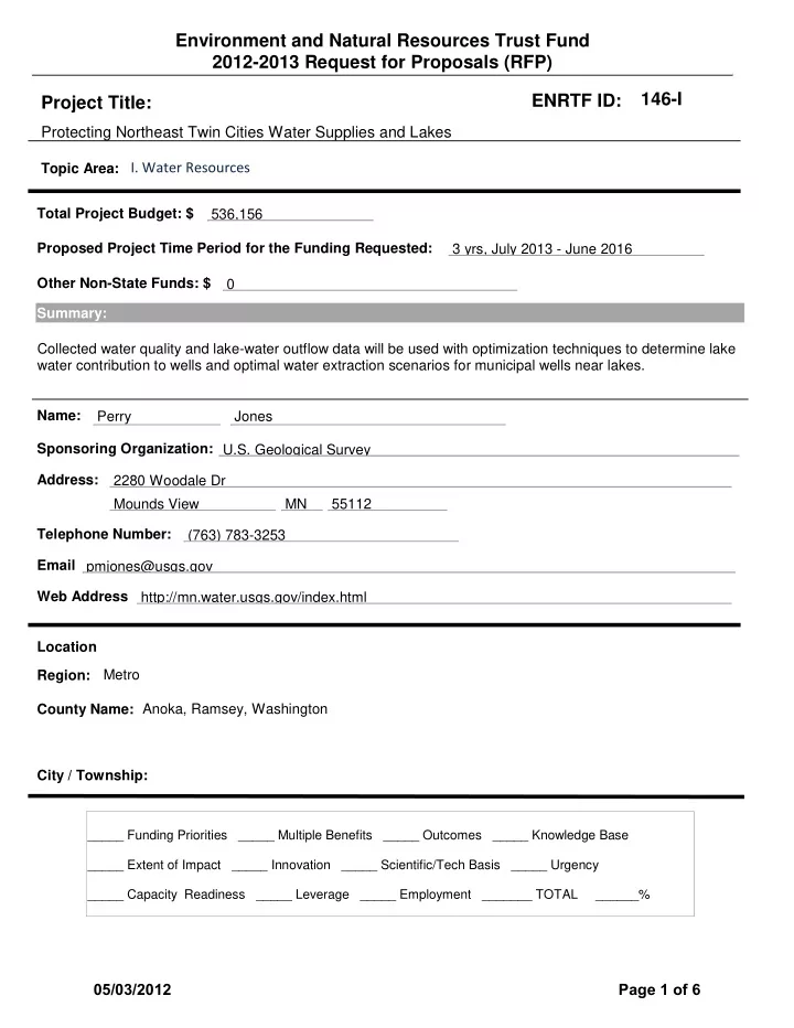
Protecting Northeast Twin Cities Water Supplies and Lakes
536,156 3 yrs, July 2013 - June 2016 Collected water quality and lake-water outflow data will be used with optimization techniques to determine lake water contribution to wells and optimal water extraction scenarios for municipal wells near lakes. Perry U.S. Geological Survey 2280 Woodale Dr Mounds View MN 55112 (763) 783-3253 pmjones@usgs.gov http://mn.water.usgs.gov/index.html Metro Anoka, Ramsey, Washington Jones
_____ Funding Priorities _____ Multiple Benefits _____ Outcomes _____ Knowledge Base _____ Extent of Impact _____ Innovation _____ Scientific/Tech Basis _____ Urgency _____ Capacity Readiness _____ Leverage _____ Employment _______ TOTAL ______%
ENRTF ID: 146-I
Topic Area:
05/03/2012 Page 1 of 6
SLIDE 2 Environment and Natural Resources Trust Fund (ENRTF) 2012‐2013 Main Proposal
1 PROJECT TITLE: Protecting Northeast Twin Cities Water Supplies and Lakes
Results from this project will provide NE TCMA municipalities with decision‐making tools critical for meeting drinking water demands while minimizing impacts to lake water levels. Municipal pumping schemes must be managed to meet water demands with minimal impacts on lake levels in the NE Twin Cities Metropolitan Area (NE TCMA). Optimization techniques can be used with water quality, level, and extraction data to determine the optimal pumping schemes. In this proposed project, water quality, level, extraction, and lake water outflow data will be collected from lakes and municipal wells and used with groundwater‐flow models to assess the susceptibility of lakes to water loss to wells. Optimization simulations will be developed to determine 1) water extraction scenarios that will have minimal or reduced impacts on local lake water levels and 2) the economic costs of potential additional water treatment and management for municipalities. The presence of lake water in wells and lower lake levels can have adverse economic impacts on municipalities through higher costs with water treatment, additional land‐use restrictions associated with source‐water protection management, and lost revenue from reduced recreational use on lakes. Water‐chemistry data recently collected from wells near White Bear Lake indicate that lake water is reaching deeper glacial aquifers and the Prairie du Chien‐Jordan aquifer, the main aquifer used for municipal water supplies in the NE TCMA and much of SE Minnesota. Water levels in many lakes in NE TCMA, including White Bear Lake, have reached historically low levels, due in part to more water extraction from Prairie du Chien‐Jordan aquifer. Municipal water extraction rates from the aquifer have more than doubled since 1980, resulting in lower groundwater levels and potentially more lake water flow to underlying aquifers and local wells. Determining the contribution of lake water to municipal wells is critical in effectively protecting municipal water supplies and local lakes.
- II. DESCRIPTION OF PROJECT ACTIVITIES
Activity 1: Determine lake water interactions with municipal wells in the NE TCMA Budget: $135,800
- 1. Bimonthly water samples will be collected from municipal wells, lakes, rainfall, and snow.
- 2. Water samples will be analyzed for stable isotope composition, which will determine for each
well 1) if lake water is entering the well, 2) the percentage of contribution of lake water to the well, and 3) seasonal changes in the lake‐water contribution to the wells.
- 3. Water sample will be collected from each well and lake for age‐dating (SF6) to assess travel
times between lakes and wells. Outcome Completion Date
- 1. Determine Well/Lake Interactions – Collect/Analyze Water‐quality Samples
12‐01‐2014
- 2. Identify and Quantify Lake Water Contribution to Wells – Water‐quality/Age‐
dating analysis – to be used in groundwater‐flow model developed in Activity 3 04‐01‐2015 Activity 2: Determine water outflow locations and rates from White Bear Lake Budget: $195,384
- 1. A series of marine geophysical surveys (seismic, temperature probe) will be done on White Bear
Lake to determine geology below the lake and potential outflow locations.
- 2. Lake cores will be collected and temporary mini piezometers and seepage meters will be
installed at potential outflow locations to determine permeability of the lake sediments.
- 3. Water levels in the mini piezometers and flow rates in the seepage meters will be measured,
and bromide tracer tests will be done to estimate water outflow rates through the lake bottom. Outcome Completion Date
- 1. Identify Potential Outflow Sites ‐ marine geophysical surveys
02‐30‐2014
- 2. Determine Lake Sediment Permeability/Outflow at Potential Outflow Sites
04‐30‐2014
05/03/2012 Page 2 of 6
SLIDE 3 2
- 3. Confirm and Estimate Water Outflow at Sites‐ used in groundwater‐flow model
05‐30‐2014 Activity 3: Develop optimal lake‐level/ water‐extraction management scenarios Budget: $204,970
- 1. Using the updated Metro groundwater‐flow model, a detailed groundwater‐flow model for NE
TCMA will be developed using collected water‐level, water‐quality, and lake‐water‐outflow data.
- 2. Working with state and local water managers, optimization simulations of various lake level/
water extraction management scenarios will be developed and run for NE TCMA.
- 3. Economic impacts of scenarios will be determined by incorporating pumping, water treatment,
recharge basin installations, and water management costs into optimization simulations. Outcome Completion Date
- 1. Develop Detailed Groundwater‐flow Model for NE TCMA
02‐28‐2015
- 2. Develop Potential Lake‐level/ Water‐extraction Management Scenarios
06‐30‐2015
- 3. Conduct Optimization/ Economic Assessment of Lake /Well Scenarios
6‐30‐2016
- III. PROJECT STRATEGY
- A. Project Team/Partners
Partners to receive funding from the Environment and Natural Resources Trust Fund U.S. Geological Survey: Perry M. Jones (hydrologist) will coordinate all project activities, and conduct groundwater‐flow and optimization modeling; Jared Trost (hydrologist) will manage water‐quality and age‐dating sampling and temperature‐probe survey; Donald Rosenberry (hydrologist) will quantify groundwater/lake exchanges, investigate flow paths and travel times; John Lane (geophysicist) will oversee the marine seismic survey. University of Minnesota, LacCore facility: Amy Myrbo (limnologist) will oversee lake sediment coring. Partners contributing funds or resources from other sources MN Department of Natural Resources staff will serve as the fiscal agent and oversee water‐level and water‐extraction data collection. MN Department of Health, MN Pollution Control Agency, MN Board of Water and Soil Resources, and Metropolitan Council hydrologists will assist in water‐level and ‐quality data collection, and groundwater‐flow modeling/optimization scenarios. Town of White Bear and the city of White Bear Lake: Water managers will assist in water‐quality and water extraction data collection and design of optimization scenarios.
The project will be completed in three years. Between July 2013 and June 2014, marine seismic survey, lake sediment coring, mini‐piezometer/seepage meter surveys, and tracer test will be completed, and up to 75% of water‐quality samples will be collected. Between July 2014 and June 2015, water‐quality sampling and analysis of the stable isotope and age‐dating data will be completed; the groundwater‐ flow model will be constructed; water management scenarios will be developed. Between July 2015 and June 2016, optimization model runs, economic assessments, and a final report will be completed.
- C. Long‐Term Strategy and Future Funding Needs
This proposal builds on (1) a USGS cooperative study in 2011 and 2012 characterizing groundwater and surface‐water interactions in White Bear Lake, (2) water‐level and extraction data to be collected in 2012 and 2013 by the Minnesota Department of Natural Resources and other cooperators, (3) the Metro groundwater‐flow model updated by the Metropolitan Council in 2012 and 2013, and (4) stable isotope data to be collected by the Minnesota Department of Health in 2012. The optimization simulations and groundwater‐flow models are long‐term products of this proposal, to be used by the Minnesota Department of Natural Resources hydrologist and municipal engineers to improve future joint management and protection of municipal water supplies and lakes in the NE TCMA. Training and potential model upgrades will be needed to implement the model.
05/03/2012 Page 3 of 6
SLIDE 4 BUDGET ITEM (See list of Eligible and Non-Eligible Costs, p. 11) Personnel: U.S. Geological Survey Hydrologist, GS-12, 55% FTE over 3 years, 26% fringe, manage project, coordinate all elements of the project, analyzed collected data, conduct groundwater-flow and optimization modeling Personnel: U.S. Geological Survey Hydrologist, GS-9, 55% FTE over 3 years, 30% fringe, collect water samples for water-quality and age-dating, manage and analyze data, assist in marine seismic survey, consturct temperature probe, and conduct temperature-probe survey Personnel: U.S. Geological Survey Hydrologist, GS-15, 2% FTE over 3 years, 24% fringe, advise and participate in mini piezometer, seepage meter, tracer tests, and temperature probe survey Personnel: U.S. Geological Survey Hydrologic Technician, GS-7, 44% FTE over 3 years, 22% fringe, collect water samples for water-quality and age-dating, manage and analyze data, assist in marine seismic survey, assist in construction of groundwater-flow model Personnel: U.S. Geological Survey Diver, GS-11, 2% FTE over 3 years, 30% fringe, to install seepage meters in White Bear Lake Contracts: United States Geological Survey, Branch of Geophysics - conduct and train hydrologists in marine seismic survey of White Bear Lake Contracts: University of Minnesota, LacCore Facility - collect four lake-sediment cores and penetration probe data at White Bear Lake Contracts: U.S. Geological Survey Laboratory Analytical Costs - Water-Quality and Age- dating Contracts: EPN publishing network, editing, printing, illustrations Equipment/Tools/Supplies: Construction of Mini-piezometer, Temperature Probe - PVC casing, PVC screens, sampling tubing,thermistors, cables, meters, Water-Quality Sampling Equipment and Supplies - bottles, sampling tubing, pumps, Marine Seismic Survey Supplies + Cables, Groundwater-flow Modeling Software Licence Travel: Vehicle Costs ($100 per week) - for water-quality sampling, marine seismic survey, temperature probe survey, and mini-piezometer/seepage meter/tracer tests Travel: Boats Costs ($125 per month) - for water-quality sampling, marine seismic survey and temperature probe survey in White Bear Lake and other lakes Additional Budget Items: Shipping of Equipment and Water-Quality Samples TOTAL ENVIRONMENT AND NATURAL RESOURCES TRUST FUND $ REQUEST = SOURCE OF FUNDS AMOUNT Status Other Non-State $ Being Applied to Project During Project Period: U.S. Geological Survey, Federal Water Cooperative Funds 335,738 $ Secured In-kind Services During Project Period: U.S. Geological Survey GS-15 hydrologist time - mini piezometer/seepage meter/tracer test 13,200 $ Secured In-kind Services During Project Period: Minnesota Department of Natural Resources - personnel time for collecting water-level and water extraction data (2011-2016) 50,000 $ Secured In-kind Services During Project Period: Minnesota Department of Health - 1) isotope sample analysis, 2) Source water protection grants to community public water supplies to particpate in project, and 3) and personnel time for collecting water-level, water-quality data, and assisting in groundwater flow modeling (2012-2016) 43,100 $ $30,000 Pending; $13,100 Secured In-kind Services During Project Period: Minnesota Pollution Control Agency - time for collecting water-level data and assisting in groundwater-flow modeling (2013-2016) 10,000 $ Secured In-kind Services During Project Period: Metropolitan Council - personnel time for collecting water-level data and assisting in groundwater-flow modeling (2013-2016) 10,000 $ Secured In-kind Services During Project Period: Minnesota Board of Water and Soil Resources - personnel time for collecting water-level data (2013-2016) 8,320 $ Secured Funding History: U.S. Geological Survey, Federal Water Cooperative Funds (2011-2012) - Characterizing Groundwater and Surface-Water Interactions in White Bear Lake, Minnesota Study 107,588 $ Spent Funding History: White Bear Lake Conservation District/Groundwater-Surface Water Interaction Partners (2011-2012) - Characterizing Groundwater and Surface-Water Interactions in White Bear Lake, Minnesota Study 92,492 $ Spent Funding History: Minnesota Pollution Control Agency, Minnesota Legacy Funds (2011- 2012) - Characterizing Groundwater and Surface-Water Interactions in White Bear Lake, Minnesota Study 25,000 $ Spent 71,868 $ 17,809 $ 215,027 $ 15,359 $ 12,586 $
2012-2013 Detailed Project Budget
- IV. TOTAL ENRTF REQUEST BUDGET 3 years
AMOUNT 11,872 $ 125,208 $ 8,850 $ 2,849 $ 6,589 $
536,156 $ 2,375 $ 38,641 $ 7,123 $
I:\ML2013\RFP\proposals_recevied\jones-perry_0412-2-086-Budgt
05/03/2012 Page 4 of 6
SLIDE 5 !
White Bear Lake Bald Eagle Lake Otter Lake Amelia Lake Wilkinson Lake Pleasant Lake Turtle Lake Snail Lake Vadnais Lakes Lake Gervais Lake Jane Olson Lake DeMontreville Lake Long Lake Goose Lake Birch Lake Pine Tree Lake Long Lake Mann Lake Bass Lake Sunset Lake Oneka Lake Egg Lake Rice Lake Peltier Lake George Watch Lake Centerville Lake Reshanau Lake Marshan Lake Rice Lake Deep Lake Gilfillan Lake Gem Lake Silver Lake Kohlman Lake Lost Lake Echo Lake Fish Lake Round Lake Long Lake Echo Lake Island Lake Lake Owasso South School Section Lake Masterman Lake Willow Lake
Hugo Shoreview Mahtomedi North Oaks Centerville Circle Pines White Bear Lake Vadnais Heights North Saint Paul White Bear Township Dellwood Grant Gem Lake Pine Springs Lake Elmo Maplewood Little Canada Lino Lakes Birchwood Willernie Oakdale
WASHINGTON COUNTY RAMSEY COUNTY ANOKA COUNTY
1980 1990 2000 2010 918 920 922 924 926 928 White Bear Lake Elevation in feet above mean sea level Year 1980 1990 2000 2010 2000 4000 6000 Total Municipal Other high capacity wells EXPLANATION Pumpage in millions of gallons Year
92°54'0"W 92°56'0"W 92°58'0"W 93°0'0"W 93°2'0"W 93°4'0"W 93°6'0"W 93°8'0"W 45°12'0"N 45°10'0"N 45°8'0"N 45°6'0"N 45°4'0"N 45°2'0"N
Historically Low Water Levels in many NE Twin Cities Lakes, such as White Bear Lake Municipal Water Use in NE Twin Cities more than doubled since 1980 More Water Extracted from Wells Potentially More Water Leaving Lakes to Wells 12 Cities/Townships use 43 Wells To Extract Groundwater from Prairie du Chien/Jordan Aquifer
- 3.0 to -9.0 (largest declines)
- 1.0 to -3.0 (decline)
+0.6 to -1.0 (little change) No water-level data Municipal water supplies using well water No municipal water supplies Municipal water supplies Lake water level change (in ft) from 2003 to 2010 2010 Municipal well water pumpage (in million gallons) 0 -100 101 - 250 251 - 400 401 - 550 551 - 600
Project Title: Protecting Northeast Twin Cities Water Supplies and Lakes
05/03/2012 Page 5 of 6
SLIDE 6
Project Managers Qualifications Perry M. Jones (U.S. Geological Survey hydrologist) will manage the project, coordinate all project activities, and conduct groundwater‐flow and optimization modeling. Perry has conducted water resources research at the U.S. Geological Survey, Minnesota Water Science Center for sixteen years, including research studies addressing groundwater and surface‐water interactions in wetlands, lakes, mines, and agricultural ditches. Over the past year, he has spent most of his time characterizing groundwater/surface water interactions in White Bear Lake applying a variety of hydrologic and water‐ quality techniques. He has also used groundwater‐flow models to address groundwater interactions with surface water in a variety of environments, including lakes (Grand Portage Reservation, Devils Lake (North Dakota)), reservoirs (Pokegama Reservoir, Grand Rapids, Minnesota), mine pits (Canisteo Mine, Bovey, Minnesota) underground mines (Solar Fuels, Somerset, PA), and regional groundwater systems (Grand Rapids, Minnesota, Ozark Plateaus Aquifer System). Perry is currently working with the city of Rochester, MN to develop a groundwater‐flow model to address interactions between municipal well waters and local rivers and streams in the Rochester area. He is also participating in studies to assess baseline hydrologic and water‐quality conditions in potential mining areas in northern MN, and hydrogeological characterization of the St. Lawrence Formation. He received his B.S. in Geology from State University of New York at Cortland and his M.S. in Geology at the University of Minnesota. He previously worked for seven years at the U.S. Bureau of Mines, where he conducted hydrologic research into source‐water protection in mining regions, water balance assessment and prediction in abandoned and active mines, and in‐situ leaching. Organization Description The Minnesota Water Science Center (WSC) is one of 48 Water Science Centers in the Water Resources Discipline of the U.S. Geological Survey (USGS). The Water Science Center's mission is to collect, analyze and disseminate the impartial hydrologic data and information needed to wisely manage water resources for the people of the United States and the State of Minnesota. Hydrologists and hydrologic technicians at the center 1) operate local and statewide networks to collect high‐quality data that define natural and human‐induced hydrologic conditions, 2) analyze hydrologic processes through investigations and research to increase understanding of important water‐resource issues and to promote informed decision making, and 3) maintain real‐time and historical data bases and publish peer‐reviewed interpretive and data reports to disseminate unbiased hydrologic information. To assure that the data and research is relevant and useful, the center forms partnerships with Federal, State, and local agencies, and other public organizations address hydrologic issues of concern. Funding for the Minnesota Water Science Center comes from a variety of sources, including direct Federal appropriations, other Federal agencies, and a water cooperative program that allows the Minnesota Water Science Center to partially match funding with state and local agencies.
05/03/2012 Page 6 of 6