
SLIDE 1
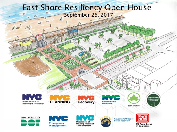
East Shore Resiliency Open House
September 26, 2017
East Shore Resiliency Open House September 26, 2017 A more - - PowerPoint PPT Presentation
East Shore Resiliency Open House September 26, 2017 A more resilient New York City A more resilient NYC is one where neighborhoods, buildings and infrastructure can withstand and recover quickly from flooding and climate events.
East Shore Resiliency Open House
September 26, 2017
A more resilient New York City
2
A more resilient NYC is one where neighborhoods, buildings and infrastructure can withstand and recover quickly from flooding and climate events.
Coastal defenses are strengthened as first line of defense against flooding and sea level rise Residents and businesses are prepared Buildings are designed to withstand and recover from flooding Infrastructure is protected from climate hazards
DCP Climate Resiliency Initiatives
3
Flood T Text I t II (2018) to be updated and made permanent
SIRR Report (2013) long-term, citywide resiliency framework PFIRM + Freeboard (2012) DOB requires most restrictive map; additional elevation Executive Order 230 (2012) mayoral
One New York (2015) moves from recovery to future resiliency
Flood T Text t (2013) initial, temporary regulations building off EO 230 SRNR R (2015) provides additional zoning relief to expedite recovery
Neighborhood Studies (2014-17) will inform the text and local rezonings
2018
Build it Back (2015) lessons learned in rebuilding effort inform zoning changes
Loc
l Rezonings gs (2017) In vulnerable areas of Queens and Staten Island
Hamilton Be ac h and Broad Channe l, Que e ns State Buyout Are as, State n IslandResilient Retail & Resilient Industry (2014-17) will inform the text
2013 Citywide Flood Resilience Text Amendment
4
ht: increased the height limit of all buildings in the floodplain by allowing height to be measured from the Design Flood Elevation (DFE), and in some cases, a higher reference point
area: allowed discounting of floor space when lost in order to come into compliance with the latest building standards (raised entryways, mechanical space, floodproofed areas)
ittin ing o
ildin ings: overrides typical zoning rules for non-complying and non-conforming buildings, giving them wide latitude to retrofit and rebuild.
ign s standards: required elevated buildings to mitigate their impact on the streetscape
*Intended to be updated based on lessons learned, expires 1 year after adoption of PFIRMs.
APPROVED
5
Resilient Neighborhoods Study Areas
Flood risk in East Shore of SI
6
Approach to future zoning + land use strategies
7
Accom
Adjust zoning to allow buildings to retrofit, by providing flexibility and removing obstacles to resiliency investments.
Encoura rage
Encourage construction of new development built to a higher standard of flood protection.
Lim imit it
Zoning and other tools should limit exposure to damage and disruption by limiting the density future development.
Flood r risk a and l local p planning g considerati tions
Where flood risk is exceptional, including places identified as buyout areas. Where risk from extreme events can be managed through infrastructure and context can support growth.
East Shore Resilient Neighborhoods Study
8
Community Advisory Committee Interagency Coordination Business Community Borough President’s Sandy Task Force
East Shore Resilient Neighborhoods Study
9
Re duc e F lood Risk Advanc e Re silie nt Building Str e ngthe n Ke y Wate r fr
De stinations Pr e se r ve Natur al E nvir
Army Co rps L ine o f Pro te c tio n + inte rio r dra ina g e Co tta g e E nve lo pe
Ac c o mmo dateNe w Do rp Be a c h
Ac c o mmo dateMidla nd Ave nue & Sa nd L a ne
E nc o urag eL imit De nsity in NYS E nha nc e d Buyo ut Are a s
L imit L*NYS Buyout Area boundaries shown for illustrative purposes
East Shore Projected Milestones
10
2017 2nd Qtr 3rd Qtr 4th Qtr 2018 2nd Qtr Beyond
East Shore Report release City Council adopted East Shore Buyout Areas text Ongoing: Draft proposal for Midland Ave/Sand Lane/New Dorp proposal & DCP Citywide Flood Text Amendment Update Begin Environmental Review/public review for Midland Ave/Sand Lane/New Dorp proposal & DCP Citywide Flood Text Amendment Update Army Corps Line of Protection and interior drainage - Design Phase Ongoing Execute Construction Agreement with NYS & NYC Initial Construction contract awards (Late 2019) DPR Shoreline Parks Plan Interim Report published in June 2017 Final phase of conceptual plan to begin - Stay tuned for kick off community meeting in Spring 2018 Last Chance Pond Park (NC-11 & NC-12) work to begin New Creek Bluebelt low flow channel (NC-7 & NC-8, and channel portions of NC-9 & NC-17 - Ongoing Hylan Boulevard (NC-13) work to begin1st Qtr 1st Qtr
Enhanced Buyout Areas East Shore Resiliency Open House
11