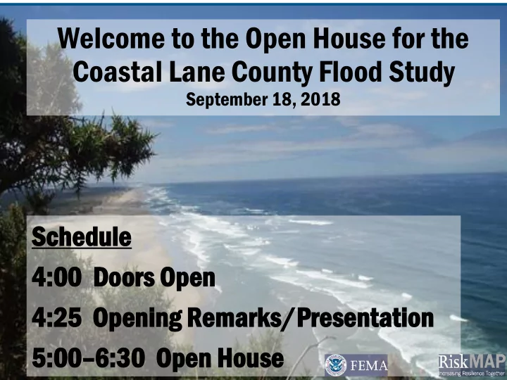
coastal lane county flood study coastal lane county flood
play

Coastal Lane County Flood Study Coastal Lane County Flood Study - PowerPoint PPT Presentation

Welcome to the Open House for the Welcome to the Open House for the Coastal Lane County Flood Study Coastal Lane County Flood Study September 18, 2018 September 18, 2018 Sch chedule le Sc Sched edule le 4: 4:00 00 Do Door ors s Op


  1. Welcome to the Open House for the Welcome to the Open House for the Coastal Lane County Flood Study Coastal Lane County Flood Study September 18, 2018 September 18, 2018 Sch chedule le Sc Sched edule le 4: 4:00 00 Do Door ors s Op Open en 4:00 4: 00 Do Door ors s Op Open en 4:25 O Openin ing g Re Remark rks/P s/Prese resenta ntation tion 4: 4:25 25 O Open ening ing Re Remark rks/Presenta s/Presentation tion 5:00 – 6: 6:30 30 Op Open en Hou ouse se 5: 5:00 00 – 6: 6:30 30 Op Open en Hou ouse se 1

  2. Coastal Lane County Flood Study Open House September 18, 2018

  3. THE BIG PICTURE STRONGER AND SAFER COMMUNITIES • Current flood hazard analysis is out of date • Flood risk changes • Our goal is to reduce risk to lives and property in the cities of Dunes City, Florence and in Lane County • Flooding is the most costly, deadly natural hazard in the United States, yet is highly predictable 3

  4. PURPOSE OF THE NFIP Reduce Economic Loss Caused By Flood Events • Maps the flood risk and assigns insurance rates • Makes flood insurance available • Sets minimum floodplain construction standards • May reduce the dependency on structural flood control • Promotes floodplain management practices increasing resilience 4

  5. FEMA FLOODING, LANE COUNTY, AND THE NFIP Flood Risk Nationally • Losses total nearly $8 Billion per year • 85% of declarations • Average of 82 fatalities per year NFIP DATA (As of July 31, 2018) JURISDICTION POLICIES IN INSURANCE IN WRITTEN PREMIUMS IN FORCE NUMER OF PAID PAYMENTS FORCE FORCE LOSSES* MADE* Dunes City 8 $2,105,000 $11,497 0 $0 Florence 153 $43,698,800 $79,841 3 $59,527 Lane County 2081 $494,155,400 $1,879,786 261 $3,175,459 5 https://bsa.nfipstat.fema.gov/reports/1011.htm#ORT *From January 1978 – July 2018 https://www.fema.gov/policy-claim-statistics-flood-insurance

  6. FEMA DISASTERS AND LANE COUNTY FEMA Public Assistance – Lane County PRESIDENTIAL YEAR PROJECT FEMA SHARE DECLARATION FUNDING 4296-DR 2017 $15,004,377 $11,505,443 4258-DR 2016 $2,278,429 $1,728,742 4169-DR 2014 $6,761,708 $5,169,277 4055-DR 2012 $1,387,681 $1,040,761 1510-DR 2004 $951,637 $713,760 1405-DR 2002 $3,904,645 $ 2,928,563 Totals $30,288,477 $ 23,086,546 https://www.fema.gov/openfema-dataset-public-assistance-funded-projects- details-v1 6

  7. MY HOUSE NEVER FLOODS… • If yo you have ve a 30 30-ye year r mort rtgage age and are re in a floodpl odplain ain, , yo you have ve a 26% ch chance ce of bei eing g flooded oded ove ver r th the te term rm of th the mort rtgage. age. http://photos.oregonlive.com • One-out ut-of of-fou four r of all flood od claims s nati tional onally ly are re outs tside de th the highest hest ri risk sk are reas. s. 7

  8. SCOPE OF WORK • Hydrology: Developed flood frequencies for Zone A streams • Hydraulics: Lidar-based approximate analysis for Zone A streams • Coastal: New analysis on the open coast for Zone VE and V • Lakes: Determined the static approximate-based BFE • Re-delineation: For Zone AE, remap floodplains using effective BFEs and LiDAR terrain data 8

  9. LIDAR (LIGHT RADAR) Millions of laser measurements are made from a precisely located aircraft, producing a 3D map of the earth’s surface as a “point cloud” Some laser pulses make it through the trees Laser pulses do not penetrate water 9

  10. TOPOGRAPHIC DATA BEFORE LIDAR Heceta Head 10 Image Credit: DOGAMI

  11. LIDAR TOPOGRAPHY Heceta Head 11 Image Credit: DOGAMI

  12. WHY REMAP COASTAL FLOOD ZONES? New methodology, guidelines, and policies for • Damage from storm waves during a “moderate” event mapping coastal flood zones; at Neskowin, Tillamook County. 30 years of new tidal gage records and storm wave • measurements; Changes in development and land use; • Construction or removal of shore protection • structures; Changes to bathymetry and/or shoreline • Availability of better topographic information (i.e. • lidar) Photo Credit: DOGAMI FEMA HQ made it a national priority (i.e. $$$) • Erosion north of Hunter Creek, Gold Beach. 12 Overtopping at Garrison Lake, Port Orford during a major storm on February 16, 1999. Photo Credit: DOGAMI Photo Credit: Unknown Image Credit: DOGAMI

  13. COASTAL MODELING PROCESS Regional Variation Local Variation Step 1: Offshore Water Step 3: Nearshore Wave Setup, Step 4: Floodplain Mapping Step 2: Offshore Waves Runup & Overtopping GIS mapping (DOGAMI) Statistical analysis of NOAA offshore buoy data; SWAN model Bathymetric survey (OSU); transect to transform to nearshore surveys and hydraulic calculations (DOGAMI & OSU) (DOGAMI) 13

  14. COASTAL TRANSECTS 57 transects surveyed from the Suislaw River north Image Credit: DOGAMI to Lincoln County Figure Credit: Modified from Hedges and Mase, 2004 14 Photo Credit: DOGAMI

  15. RIVERINE MODELING Elemen ent Approxi ximat mate Image Credit: DOGAMI 1. TERRAIN/ Extracted completely from Light Detection and LiDAR CROSS- Ranging (LiDAR) SECTIONS Survey 2. HYDROLOGY Regional Regression 3. HYDRAULICS HEC-RAS model (simplified) • (HEC-RAS) • Roughness is generalized • Structures are assumed (NBI/Aerial/Local Inventory) 15 Photo Credit: DOGAMI

  16. READING A FLOOD INSURANCE RATE MAP • 1 % Floodplain (AE, A, VE, or V) Base Flood Elevation (1 • % Water Surface Elevation) • Transect 16

  17. READING A FLOOD INSURANCE RATE MAP • Base Flood Elevation (1 % Water Surface Elevation) • Floodway • Cross-section • 1 % Floodplain (AE, A, VE, or V) 17

  18. RESULTS ON DISPLAY – WEB VIEWERS Comparison (Swipe Feature): http://arcg.is/yqiPy Risk Assessments: http://arcg.is/14mjy5 FEMA’s Flood Map Change Viewer on FEMA.gov 18

  19. Coastal Lane County Important Next Steps in the Flood Study Update 19

  20. NEXT MILESTONES* PUBLIC MEETING SEPTEMBER 18, 2018 90-DAY APPEAL PERIOD NOVEMBER 2018 TO STARTS SHORTLY AFTER THE PUBLIC MEETING FEBRUARY 2019 FEMA ISSUES LETTER OF FINAL DETERMINATION 3-6 MONTHS FOLLOWING THE END OF THE APPEAL PERIOD. DEPENDENT ON SUMMER 2019 COMMENTS AND APPEALS RECEIVED. EFFECTIVE DATE WINTER 2019/2020 6 MONTHS AFTER LFD Flood Risk Review Public Open Scoping/ Meeting for FEMA issues LFD House Discovery Community Staff Summer 2019 September, 2018 2012-2013 August 6, 2016 Preliminary Maps Released Effective Date Appeal Period CCO Meeting March 29, 2018 Late 2019/Early 2020 November 2018 thru *Subject to coordination and funding July 9, 2018 February 2019 20

  21. APPEALS A formal objection to the addition/modification of preliminary BFEs/flood depths, SFHA boundaries or zone designations, or regulatory floodway boundaries, subject to the due process requirements outlined in Part 67 of the NFIP regulations Projected Appeal Period Start: Sometime in November 2018 Appeal Period End Date: Sometime in February 2019 • The 90-day Appeal Period begins after publication in the Federal Register, and two newspaper notifications • Appeals are limited to newly mapped flood hazard data • Appeals must be supported by technical or scientific information • Demonstrates alternative methods or applications result in more correct estimates of base flood elevations. • Guidance available 21

  22. APPEALS & COMMENTS • Encou courag rage e su subm bmit itti ting ng to to your r communi mmunity ty offic icials. ials. • Comm ommuni unity ty bu bundl dles es all th the e comment ments s and d forwards rwards th them em to to FEMA MA Reg egion on 10. 10. • Form rms s are re available ilable here re at t th the ope pen n house se at t th the e engi ngine neering ering ta tabl ble. e. 22

  23. LETTER OF MAP CHANGE (AT ANY TIME) Letter Of Map Amendment (LOMA) Letter Of Map Revision (LOMR) for property owners who believe a property for communities to submit better was incorrectly included in a floodplain, technical information to change a primarily through showing that the lowest floodplain or to reflect physical changes elevation adjacent to the structure is made to the floodplain. above the 1% flood elevation. (LOMA) Hotline – 1-877-FEMA-MAP 23

  24. INFORMATION TABLES Property Flood Study / Identification & Flood Insurance Engineering Digital Mapping Floodplain State Table City Table Regulations 24

  25. INFORMATION TABLES Flood od St Study/ dy/Engi Engineer neering ing Prop oper erty ty ID & Digital al Flood od Insu surance ance Mapp pping ng Understand the methodology, data, and technical Learn about your insurance Receive a printed map specifications of the analysis and policy options and rates of your property and understand learn about options to applicable to mapped flood the flood zone and risks on or incorporate additional data and zones near your property SOMAs Flood odplai lain n Regulat lations ons County/Cit ity Tab ables es Other er Hazar ard Infor ormati mation on Gather information on the NFIP Ask about local Information about tsunami and and building requirements / seismic hazards, grant programs, floodplain regulations, restrictions, and the NFIP disaster preparedness, risk permitting processes, projects, Biological Opinion on the reduction and other hazards and hazard planning Endangered Species Act 25

  26. Coastal Lane County Making Your Home and Community Safer and Stronger 26

Download Presentation
Download Policy: The content available on the website is offered to you 'AS IS' for your personal information and use only. It cannot be commercialized, licensed, or distributed on other websites without prior consent from the author. To download a presentation, simply click this link. If you encounter any difficulties during the download process, it's possible that the publisher has removed the file from their server.

Recommend


More recommend