C o n w a y R d Example Intersection Legend Warson Rd - - PowerPoint PPT Presentation

c o n w a y r d
SMART_READER_LITE
LIVE PREVIEW

C o n w a y R d Example Intersection Legend Warson Rd - - PowerPoint PPT Presentation

Concept Plan Alternatives Warson Road Study Ladue, Missouri 1:50 SCALE C o n w a y R d Example Intersection Legend Warson Rd Proposed Roadway Existing R/W (St. Louis County Property Map) Proposed R/W Disclaimer: Property lines are


slide-1
SLIDE 1

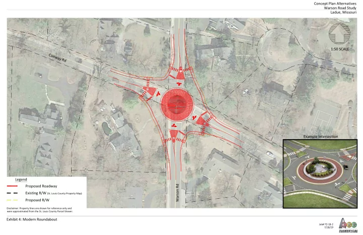
Concept Plan Alternatives Warson Road Study Ladue, Missouri Exhibit 4: Modern Roundabout

Job# 72-18-2 7/18/19

C

  • n

w a y R d Warson Rd 1:50 SCALE

Disclaimer: Property lines are shown for reference only and were approximated from the St. Louis County Parcel Viewer.

Example Intersection Legend Proposed Roadway Existing R/W (St. Louis County Property Map) Proposed R/W

slide-2
SLIDE 2

Concept Plan Alternatives Warson Road Study Ladue, Missouri Exhibit 1: Signalized Intersection with No Left Turn Lanes

Job# 72-18-2 7/18/19

C

  • n

w a y R d Warson Rd Legend Proposed Roadway Existing R/W (St. Louis County Property Map) Proposed R/W 1:40 SCALE

Disclaimer: Property lines are shown for reference only and were approximated from the St. Louis County Parcel Viewer.

Example Intersection: Clayton Road at Lay Road

slide-3
SLIDE 3

Concept Plan Alternatives Warson Road Study Ladue, Missouri Exhibit 3: Mini Roundabout

Job# 72-18-2 7/18/19

C

  • n

w a y R d Warson Rd 1:40 SCALE

Disclaimer: Property lines are shown for reference only and were approximated from the St. Louis County Parcel Viewer.

Example Intersection Legend Proposed Roadway Existing R/W (St. Louis County Property Map) Proposed R/W

slide-4
SLIDE 4

Concept Plan Alternatives Warson Road Study Ladue, Missouri Exhibit 2: Signalized Intersection with Left Turn Lanes

Job# 72-18-2 7/18/19

Conway Rd Warson Rd 1:70 SCALE

Disclaimer: Property lines are shown for reference only and were approximated from the St. Louis County Parcel Viewer.

Example Intersection: Warson Road at Ladue Road Legend Proposed Roadway Existing R/W (St. Louis County Property Map) Proposed R/W

slide-5
SLIDE 5

Job# 04/02/19 072-18-2

Exhibit 1: Existing Traffic Volumes

Warson Road Warson Road Picardy Lane North Pebble Creek Road Picardy Lane South Forcee Lane Conway Road Conway Road Warson Terrace North Lot Loop Entrance Loop Exit South Lot Foxboro Road South Lot Foxboro Road Springwood Drive Pebble Creek Road Picardy Lane North Picardy Lane South Forcee Lane C

  • n

w a y R

  • a

d Conway Road Warson Terrace Loop Entrance Loop Entrance South Lot Foxboro Road Foxboro Road Springwood Drive South Lot Loop Exit

2 (1) <4> 0 (1) <2> 0 (5) <5> 345 (350) <285> 0 (2) <1> 0 (0) <1> 1 (1) <0> 0 (2) <5> 325 (260) <500> 0 (2) <1> 4 (4) <1> 2 (4) <0> 4 (5) <5> 345 (350) <290> 1 (0) <1> 0 (1) <1> 1 (0) <0> 0 (0) <0> 325 (260) <500> 0 (0) <0> 85 (70) <65> 105 (115) <145> 90 (20) <45> 25 (45) <20> 235 (250) <190> 50 (110) <60> 30 (35) <40> 120 (80) <115> 180 (75) <240> 75 (45) <45> 235 (185) <430> 16 (35) <25> 2 (3) <2> 2 (9) <4> 2 (10) <6> 305 (400) <265> 7 (2) <6> 305 (280) <235> 90 (11) <180> 320 (250) <610> 190 (25) <105> 3 (110) <35> 13 (110) <55> 395 (295) <415> 55 (7) <2> 180 (350) <665> 145 (13) <5> 90 (20) <4> 110 (15) <3> 0 (2) <2> 1 (2) <1> 355 (280) <410> 0 (2) <2> 240 (325) <680> 50 (40) <5> 355 (280) <410> 70 (40) <13> 0 (1) <2> 1 (0) <0> 0 (3) <0> 0 (0) <1> 0 (3) <1> 400 (250) <405> 120 (7) <4> 25 (70) <12> 115 (130) <7> 0 (0) <0> 245 (335) <655> 4 (2) <1> 8 (5) <8> 18 (15) <17> 355 (445) <660> 6 (17) <16> 515 (250) <395> 10 (15) <14>

1 2 3 5 6 7 8 9 11 4 10

1 2 3 4 6 7 8 9 10 11

n.t.s. n.t.s.

Legend

( ) XX XX = Traffic (2:30 - 3:30 ) School Dismissal PM = Peak Hour Traffic (7:00 - 8:00 ) AM AM = Existing Side-Street Stop Control = Existing All-Way Stop Control = Non-permissable Movement <XX> = Peak Hour Traffic (5:00 - 6:00 ) PM PM

Clayton Road

64 64

505 (280) <715> 180 (350) <665> 290 (365) <665> 355 (280) <410> 0 (4) <5>

slide-6
SLIDE 6

Job# 04/02/19 072-18-2

Exhibit 2: 20-Year Forecasted Traffic Volumes

Warson Road Warson Road Picardy Lane North Pebble Creek Road Picardy Lane South Forcee Lane Conway Road Conway Road Warson Terrace North Lot Loop Entrance Loop Exit South Lot Foxboro Road South Lot Foxboro Road Springwood Drive Pebble Creek Road Picardy Lane North Picardy Lane South Forcee Lane C

  • n

w a y R

  • a

d Conway Road Warson Terrace Loop Entrance Loop Entrance South Lot Foxboro Road Foxboro Road Springwood Drive South Lot Loop Exit

2 (1) <4> 0 (1) <2> 0 (5) <5> 370 (380) <315> 0 (2) <1> 0 (0) <1> 1 (1) <0> 0 (2) <5> 355 (290) <530> 0 (2) <1> 4 (4) <1> 2 (4) <0> 4 (5) <5> 370 (380) <320> 1 (0) <1> 0 (1) <1> 1 (0) <0> 0 (0) <0> 355 (290) <530> 0 (0) <0> 90 (75) <70> 110 (120) <155> 95 (20) <50> 25 (50) <20> 255 (275) <210> 55 (115) <65> 30 (35) <45> 125 (85) <120> 190 (80) <255> 80 (50) <50> 260 (210) <455> 20 (35) <25> 2 (3) <2> 2 (9) <4> 2 (10) <6> 330 (435) <290> 7 (2) <6> 330 (310) <255> 100 (15) <190> 350 (275) <650> 200 (30) <110> 5 (115) <40> 15 (115) <60> 430 (325) <445> 60 (7) <2> 205 (380) <710> 150 (15) <5> 100 (20) <4> 120 (15) <3> 0 (2) <2> 1 (2) <1> 385 (310) <440> 0 (2) <2> 270 (350) <725> 55 (45) <5> 385 (310) <440> 75 (45) <15> 0 (1) <2> 1 (0) <0> 0 (3) <0> 0 (0) <1> 0 (3) <1> 435 (280) <435> 125 (7) <4> 25 (75) <15> 120 (135) <10> 0 (0) <0> 275 (360) <700> 4 (2) <1> 8 (5) <8> 18 (15) <17> 390 (480) <705> 6 (17) <16> 555 (280) <425> 10 (15) <14>

1 2 3 5 6 7 8 9 11 4 10

1 2 3 4 6 7 8 9 10 11

n.t.s. n.t.s.

Legend

( ) XX XX = Traffic (2:30 - 3:30 ) School Dismissal PM = Peak Hour Traffic (7:00 - 8:00 ) AM AM = Existing Side-Street Stop Control = Existing All-Way Stop Control = Non-permissable Movement <XX> = Peak Hour Traffic (5:00 - 6:00 ) PM PM

Clayton Road

64 64

545 (310) <760> 205 (380) <710> 325 (395) <710> 385 (310) <440> 0 (4) <5>