Briefing Note 3 August 2016 Bangladesh Floods Need for - - PowerPoint PPT Presentation

briefing note 3 august 2016
SMART_READER_LITE
LIVE PREVIEW

Briefing Note 3 August 2016 Bangladesh Floods Need for - - PowerPoint PPT Presentation

ACAPS Briefing Note: Floods in Bangladesh Briefing Note 3 August 2016 Bangladesh Floods Need for international Not required Low Moderate Significant Major Key findings assistance X Very low Low Moderate Significant Major


slide-1
SLIDE 1

ACAPS Briefing Note: Floods in Bangladesh 1

Briefing Note – 3 August 2016

Bangladesh

Floods

Need for international assistance

Not required Low Moderate Significant Major

X

Very low Low Moderate Significant Major

Expected impact X

Crisis overview

More heavy rains due in Bangladesh: Forecast 1–7 August 2016

Source: ECHO 01/08/2016.

As of 3 August, some 3.2 million people across 16 districts of Bangladesh have been affected by monsoon-induced floods that began around 22 July. 42 deaths have been recorded and 38 officially confirmed, including mostly drowned minors, as nearly 7,400 people have sought refuge in 69 flood shelters. Some 250,000 houses have been destroyed or damaged. The affected populations are mainly in need of food, water and emergency shelter. More than 300,000 people are stranded in Shariatpur and Faridpur districts (OCHA 31/07/2016, ECHO 01/08/2016, BDN News 02/08/2016, ECHO 03/08/2016). Humanitarian partners and the government have so far been unable to reach the targeted population with sufficient aid deliveries.

Key findings

Anticipated scope and scale

16 districts in northern and central Bangladesh, including Bogra, Faridpur, Gaibandha, Jamalpur, Kurigram, Kustia, Lalmonirhat, Madaripur, Manikganj, Nilphamary, Rajbari, Rangpur, Sariatpur, Sirajgonj, Sunamgonj, and Tangail are currently affected by severe flooding. Floodwaters are slowly retreating in the north. In central Bangladesh continued rains, especially in the capital region, are putting hundreds of thousands of people at risk.

Priorities for humanitarian intervention

 Food provision  Drinking water, sanitation and hygiene  Emergency shelter

Humanitarian constraints

Road closures and flooding of railway tracks hamper access to affected populations

Limitations Despite the slow onset of the disaster, flood monitoring has been limited to recording river flooding levels and casualties. More precise data on the needs of the affected population is lacking. Since the flooding is affecting the entire country, the flow of information is fragmented, making it difficult to assess the needs of all affected regions.

Pink 200mm of rainfall and above Dark- blue 50–100 mm of rainfall Light- blue 25–50 mm of rainfall

slide-2
SLIDE 2

ACAPS Briefing Note: Floods in Bangladesh 2

Crisis impact

This monsoon’s flooding is being called the worst in Bangladesh since 1998 (Save the

Children 01/08/2016). More than 3.2 million people have been affected by monsoon-related

flooding and over 250,000 houses have been damaged or destroyed. 17 people have been killed (OCHA 31/07/2016, ECHO 01/08/2016, BDN News 02/08/2016, ECHO 03/08/2016). The northwest,

  • ne of the hardest-hit regions, is particularly vulnerable due to widespread underlying

poverty. The flood-prone areas in Lalmonirhat have so far been most affected by flash floods (Daily

Star 01/08/2016). In the north of the country, waters are slowly receding yet the

humanitarian situation remains difficult. The Brahmaputra–Jamuna and Surma– Kushiyara River levels rose from 7cm above danger level on 12 July to 42cm above danger level on 1 August, but are now falling and may continue to fall in the next 72 hours

(Government 12/07/2016). Flooding levels still exceed the danger levels on all major rivers (Disaster Forum Dhaka 30/07/2016).

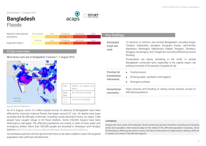
Previously unaffected areas in Bangladesh’s central and southern districts are experiencing severe flooding, particularly Madaripur, Manikganj, Sariatpur and the Dhaka capital region (see map below). Ou Outlook: The Flood Forecast and Warning Centre predicts worsening floods in central districts, with 19 major rivers still above danger level (ECHO 01/08/2016). The Ganges river basin was rising as of 3 August, having risen continuously between 17 July and 1 August

(Government 17/07/2016, Government 03/08/2016). The Padma River remains at steady high

levels, up to 82cm above danger level, which will cause the flooding situation in the lowlands adjacent to Rajbari, Manikganj, Munshiganj and Sariotpur districts to remain

  • critical. The Buriganga, Balu, and Lakhya Rivers around Dhaka city are rising, and this will

likely to continue till at least 4 August and seriously endanger the capital (Government

01/08/2016, Government 03/08/2016).

Food securi rity and d livel elihoods ds: As of 1 August, at least 61,000 hectares of crops are flooded (ECHO 01/08/2016). In Lalmonirhat, Jamalpur, Gaibandha, Manikganj, Munshiganj, and Tangail, the affected population is facing acute food shortages, while there is a growing lack of fodder for cattle (Daily Star 01/08/2016). Reports suggest that sources of livelihoods have been destroyed, including fish farms and paddy fields, and farmers have no seeds. Food prices are expected to rise and shortages are likely in the flood-affected regions (GUK Documentation, Monitoring and Publication Cell 02/08/2016). Health and and WASH SH: There is a reported outbreak of waterborne diseases in the northern

  • provinces. People have contracted diarrhoea, dysentery, and typhoid as drinking water

has been contaminated. People in Lalmonirhat, Jamalpur, Gaibandha, Manikganj, Munshiganj, and Tangail lack drinking water. Two health facilities in Kalirbazar have been flooded and are no longer operational (Daily Star 01/08/2016). 103 diarrhoeal cases, 60 RTI cases, 42 skin disease cases, 41 eye infection cases and 68 injuries have been reported so far from government health facilities. Flood shelters often have inadequate WASH facilities (Save the Children 2006). Open defecation is reportedly increasing and the absence of hygiene equipment and safe drinking water heightens the risk of possible outbreaks. Sh Shelter: r: More than 250,000 houses have been damaged or destroyed across the country

(ECHO 03/08/2016). As in previous floods, there are people taking shelter on the roof of their

houses putting themselves at risk of being inundated along with their houses. Nutri rition: Flooding after Cyclone Roanu disrupted treatment of SAM, and a lack of community-based screening means poor nutrition outcomes are potentially underreported (HCTT 01/06/2016). Flooding following monsoon rainfall that hit the northern provinces of Bangladesh in 2014 left some 370,000 people acutely malnourished (ECHO

17/11/2015).

Ed Education: In the affected provinces of Jamalpur, Sunamganj, Sirajganj, Bogra, Kurigram, Gaibandha, Tangail, Nilphamari, Lalmonirhat, and Faridpur, over 1,200 schools have been closed due to flooding (Disaster Forum Dhaka 30/07/2016).

Impact on critical infrastructure

Railway connections on the Jamalpur–Bangabandhu Bridge (east) and Jamalpur– Dewanganj routes are suspended as railway tracks have been submerged and need

  • repair. Since 30 July, two 200m stretches of the Jamalpur–Sharishabari road in Phulbaria

area were damaged by floodwater, suspending traffic (Daily Star 01/08/2016). The Jamuna bridge is an important link between the east and west of the country.

Vulnerable groups affected

Children, women, the elderly, and people with disabilities are among the most vulnerable population groups. Households dependent on fishing, who live on riverbanks, were among the first victims (Dhaka Tribune 25/07/2016).

slide-3
SLIDE 3

ACAPS Briefing Note: Floods in Bangladesh 3

Humanitarian and operational constraints

 Blocked roads and railways complicate the delivery of relief goods, so the first response has mainly been in the form of cash support (Dhaka Tribune 25/07/2016, ECHO

01/08/2016).

 A reduced presence of humanitarian actors from the Shelter Cluster makes it harder to deliver a fast and efficient response in the northern provinces (4W Atlas – Humanitarian

Agencies in Bangladesh 2014).

 Recent attacks on Westerners in Dhaka, with 20 hostages recently killed by Islamist extremists, have increased insecurity for humanitarian workers (The Guardian

03/07/2016). This could lead to constraints for humanitarians travelling outside the

capital.

Aggravating factors

Weather and natural hazards

The months from June–October are the wettest and bring humid climate and heavy

  • rainfall. Bangladesh has a multitude of rivers and a generally low altitude with many areas

no higher than 5–10m above sea level (Geography Site Bangladesh Country Page).

Population density

Population density in Bangladesh is 1,014 people/km2, making it the eighth most densely populated country in the world (WB Indicators). Dhaka is the world’s most densely populated city at 43,500 inhabitants/km2 within the city limits (International Business Times 11/07/2015). Most people live in areas less than 5m above sea level, leaving a large population highly vulnerable to cyclones and flooding (Al Jazeera 22/05/2016).

Location and type of housing/infrastructure

Houses are often built on mud platforms (or plinths). Many of those affected by floods camp out on roofs, roads, embankments or bamboo structures. Children in these situations are extremely vulnerable and less likely to receive assistance than children in flood shelters, as they are harder to identify and harder to reach (SC 2006).

Poverty

Poverty is persistent in three areas: the northwest, the central northern region, and the southern coastal zones (IFAD 06/2014). Poor populations are more vulnerable to the effects

  • f floods and crop losses, and will take longer to recover.

Coping mechanisms

In southern Bangladesh, frequent cyclone and flooding events have driven a diversity of coping mechanisms among households. Some of the most important are livelihood diversification, informal risk sharing within communities, and migration. However, root causes of vulnerability have been inadequately addressed, meaning that coping mechanisms are regularly viewed as the norm (Lund University 08/2012). Households have begun to cultivate saline-tolerant rice and vegetables. Drip irrigation and rainwater harvesting are becoming more common. Mud walls are replaced with bamboo or wood to avoid being washed away by storm surges. Community savings groups have formed to prepare for the next disaster. Pastoralists are rearing smaller animals to avoid overreliance on scarce pasture and fresh water. Shrimp farming is being taken up to diversify income (American Journal of Rural Development 2015).

Key characteristics

Demogra raphic pro rofile: Bangladesh population: 149,772,364 (2011). Urban population: 28.4% (2011) (CIA WorldFactbook 2014). Population of the most affected districts: Kurigram: 2,205,683; Gaibandha: 1,418,618; Lalmonirhat: 1,338,702; Bogra: 800,967; Sirajganj: 2,022,246; Jamalpur: 2,444,418

(Government/WFP Assessment 31/07/2016).

WASH SH: Access to improved sources of drinking water: 83.2% (2011); access to improved sanitation facilities: 54.7% (2011) (UNICEF 12/2013). Water quality in Bangladesh is compromised by the presence of arsenic, detected in 61 of 64 districts. It is at dangerous levels for at least 20 million people (UNICEF 2009). Lighting and d cooking: Population using solid fuels for cooking: 99% rural; 59.9% urban

(Global Alliance for Clean Cookstoves).

Health: Infant mortality rate: 33/1,000 live births; under-five mortality rate: 41/1,000 live births; maternal mortality ratio: 240 deaths per 100,000 pregnancies (UNICEF 12/2013).

slide-4
SLIDE 4

ACAPS Briefing Note: Floods in Bangladesh 4

Food: Although food insecurity is relatively high in northeastern, southeastern, and northwestern Bangladesh, the central districts are broadly food secure. Food access, food use, sanitation, caring practices, and poverty are the main drivers of food insecurity. Jamalpur, Bogra, Sirajganj, and Gaibandndha districts in the flood-affected northwest, are in Stressed and Crisis (IPC Phases 2-3) food security (Food Security Cluster 28/06/2016). Nutri rition: 41% of children under five suffer from chronic malnutrition (WFP 2015). As of January 2016, GAM was 14% (WFP 2016). Litera racy: Adults (total population over 15): 57.7%; Youth (18–24 years): 77.1%; Male: 80.4% (UNICEF 12/2013).

Response capacity

Local and national response capacity

The government has reacted by releasing immediate cash support of 25 million BDT and 21 million BDT allocated to food support as well as 6,600 MT rice. (ECHO 01/08/2016). Disaster management is the responsibility of the Ministry of Disaster Management and

  • Relief. Bodies which support disaster management include: the National Disaster

Management Coordination Council (responsible for implementing policies), the National Disaster Management Advisory Council, the National Platform Disaster Management for Risk Reduction (coordinating and providing facilitation to relevant stakeholders), the Focal Point Operation Coordination Group of Disaster Management (reviewing and coordinating activities carried out by different departments), the NGO Coordination Committee of Disaster Management and the Committee for Speedy Dissemination of Disaster Related Warning/Signals (SOD 2010). Disaster Management Committees (DMC) exist at the district, upazila, and union level, although the level of activity of these DMCs varies (JNA ACAPS 04/2014). All INGOs and NGOs require government approval to undertake projects. Approval in non- emergency situations takes a minimum of 45 days, while if a disaster has been declared, approval can be granted in 24 hours (JNA ACAPS 04/2014).

International response capacity

As of 20 June there is an enhanced international relief presence in Bangladesh across all sectors including INGOs. The Red Cross/Red Crescent movement as well as multiple UN

  • rganisations are present in the country (UN Country Team 20/06/2016). The northern area

has three or more INGOs in each of the Early Recovery, Food Security, Health, WASH and Nutrition Clusters. However, organisations specialised in shelter sector are lacking (4W

Atlas – Humanitarian Agencies in Bangladesh 2014). Due to poverty and enhanced vulnerability, the

northwestern provinces are of particular concern.

Information gaps and needs

Information in the affected areas beyond the basic needs assessed by first rapid assessment at the end of July is now needed. Both sectoral needs and district level data are widely unavailable.

Lessons learned

 In the 1998 floods that left some 30 million people homeless and killed more than 1,000, the capital was flooded as well (GEO Bytes GCSE 03/12/2006). Since then the city

  • f Dhaka has grown considerably from a population of about 10 million people to
  • ver 17 million (Geohive 2016). As a consequence, the casualties and damage would

be much higher today than they were 18 year ago.  Slow build-up of recent flood events has previously allowed for evacuation, though many could only flee with their most important belongings.  Resources should be allocated to help people adopt a lifestyle that conforms to their natural environment. Solutions such as changing housing structures and crop patterns can help reduce flood and storm damage.  Good governance, appropriate environmental laws, acts, and ordinances will be necessary to achieve sustainable economic development and to reduce any environmental degradation.  Implementation of an improved real-time flood and drought control warning system can reduce the damage caused by floods and cyclones. Improved forecasting and early warning systems and preparedness measures have helped to reduce the number of lives lost and impact on livelihoods by flood.

Sources: WFP 19/20/2014, JNA ACAPS 04/2014.

slide-5
SLIDE 5

ACAPS Briefing Note: Floods in Bangladesh 5

Maps

Source: Government of Bangladesh 2016 Source: Prevention Web Bangladesh Maps, 2007

slide-6
SLIDE 6

ACAPS Briefing Note: Floods in Bangladesh 6

Satellite detected flood water extend in Dhaka capital region of Bangladesh

Source: UNOSAT 24/07/2016)