
SLIDE 1
Columbia Gorge Geology and the Ice Age Floods
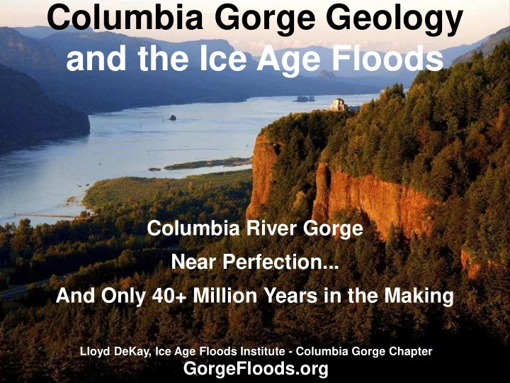
Columbia River Gorge Near Perfection... And Only 40+ Million Years in the Making
Lloyd DeKay, Ice Age Floods Institute - Columbia Gorge Chapter
and the Ice Age Floods Columbia River Gorge Near Perfection... And - - PowerPoint PPT Presentation
Columbia Gorge Geology and the Ice Age Floods Columbia River Gorge Near Perfection... And Only 40+ Million Years in the Making Lloyd DeKay, Ice Age Floods Institute - Columbia Gorge Chapter GorgeFloods.org Geologic Time If 1 MY = 1
Lloyd DeKay, Ice Age Floods Institute - Columbia Gorge Chapter
Geology has a very long time to do its work
Dinosaurs Gone = 65in Columbia River trough = ~50in Columbia River = 20in Columbia River Basalt = 17.5-14in Ice Age Floods = .018in Earth formed = 125yd BIG BANG = 1/4mi
John Day Fossil Beds National Monument
Volcanic ash from these proto-Cascade volcanos blowing eastward repeatedly buried the John Day area, preserving the world's most complete record of Miocene life
John Day Fossil Beds Natl Monument
Meanwhile weathered volcanic debris washed down the arc flanks into the Columbia trough
Eagle Creek Debris Flow ~20MYA
About 17.5 MYA volcanism shifted east to the Idaho border area, burying the Columbia Basin in 1000’s of feet of basalt
There were over 300 MASSIVE fissure eruptions that poured extremely fluid basalt from 20,000 vents, up to 30' wide and 10mi long
Stacked Basalt Layers – Horsethief Butte
Pillow Basalt - Hwy 197, I-84 exit south
Basalt Pillows Basalt Columns
Curved Columns Horsethief Butte Basalt Arch – Catherine Creek
Mt Defiance @ sunset Frosty Underwood Mtn
Mt Hood Mt Adams
Collapsed Lava Tubes – White Salmon River
Folded CRB – Coyote Wall, SR14 east of Bingen
Lava Tubes – Guler Ice Caves, Trout Lake Bird Crk Meadows – Mt Adams
At the end of the ice ages,18-12 KYA, ice dams repeatedly blocked the Clark Fork River creating Glacial Lake Missoula
The lake floated and undermined the ice dam, causing catastrophic collapse The floods swept away icebergs carrying encased rock that later melted out downstream as erratics.
Maybe 120 times (~every 50 years) these Ice dams broke catastrophically, releasing huge floods up to 1000' deep that raced at up to 60 mph across central WA, through Wallula Gap, the Gorge, and on to the Pacific Ocean
Dry Falls
Stev Ominski
140 mi3/day poured across the eastern WA landscape It striped sediment and plucked massive blocks of bedrock behind a wall of water up to 1000’ high. It could have been felt 2 hours beforehand. It left behind massive coulees, scablands, mega- ripples and bars, even lake deposits.
Touchet Lake Beds Deposited inTemporary Lakes Huge Coulees and Scablands Mega-Ripples 30+ ft high (Camas Prairie) Massive Rolled Basalt Boulders
Stev Ominski
Columbia River Gorge
Peter Marbach
Kolk Pond at The Dalles Discovery Center
Whirlpools plucked bedrock
Streamlined Bedrock Outcrops Horsethief Butte, WA Turbulent Water-Cut Benches opposite Dalles Discovery Center
Scablands at Columbia Hills State Park, WA
Upstream Dipping Foreset Beds (Canyon Road, Lyle)
Hanging Valleys with Spectacular Gorge Waterfalls like Multnomah Falls off I-84
Challenged by Six Geology Elders
Henry Ferguson Oscar E. Meinzer
James Gilluly
James Gilluly Oscar E. Meinzer
The Elders fought Bretz’s “heretical” neo-Catastrophist explanation until Joseph T. Pardee’s 1940 Glacial Lake Missoula presentation that provided the source for the floods and ended the debate
J Harlan Bretz Neo-Catastrophist in 1923
Joseph T. Pardee Proposed a megaflood explanation, but not where floods came from
Landsat Image (1970s) Bretz Map (1930s)
Bonneville Dam
Wy’east (Mt Hood) Pahtoe (Mt Adams) Loowit (Mt St Helens)
Proto-Cascades Cascades, Ice Age Floods, and Columbia River Gorge
Mt Washington
Columbia River Basalts