SLIDE 1 1
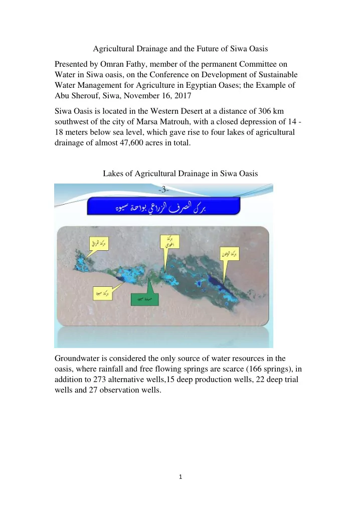
Agricultural Drainage and the Future of Siwa Oasis Presented by Omran Fathy, member of the permanent Committee on Water in Siwa oasis, on the Conference on Development of Sustainable Water Management for Agriculture in Egyptian Oases; the Example of Abu Sherouf, Siwa, November 16, 2017 Siwa Oasis is located in the Western Desert at a distance of 306 km southwest of the city of Marsa Matrouh, with a closed depression of 14 - 18 meters below sea level, which gave rise to four lakes of agricultural drainage of almost 47,600 acres in total. Lakes of Agricultural Drainage in Siwa Oasis Groundwater is considered the only source of water resources in the
- asis, where rainfall and free flowing springs are scarce (166 springs), in
addition to 273 alternative wells,15 deep production wells, 22 deep trial wells and 27 observation wells.
SLIDE 2
2
An illustration of an alternative ministerial well (with a tight lock) An illustration of a main ministerial irrigation canal for providing water and prevention of water leakage
SLIDE 3 3
Agricultural drainage system 1- The agricultural drainage water is drained through: A - Field drainage that ends in head drainage B - Head drainages transitioning to relatively low-lying areas These consist of four lakes with a total area of almost 47,600acres:
- Aghurmi Lake and Zeitouna Lake to the east
- Siwa Lake and Maraqi Lake to the west
C - The drainage system depends on the disposal of wastewater from lakes through evaporation With the beginning of the nineties, the expansion of the land reclamation significantly increased until it reached about 9,000 acres.This prompted residents to dig surface (random) wells numbering about 1,250 wells, of which nearly 611 remain. The main causes of the drainage problem: 1- There is no natural depression inside the oasis 2- The existence of an impermeable layer in the ground that does not let water through 3- Use of the flooding irrigation system, necessitated by salinity of the soil, except in sandy land to the south of the oasis 4- The presence of natural springs that are difficult to control There are natural springs leaking directly into the lakes 5- Disruption of natural equilibrium between the evaporation rates and the quantities of water drained into the lakes, especially in the winter. Which led to: 1- Converting land suitable for reclamation to marshes unsuitable for agriculture (because of high salinity)
SLIDE 4
4
2- Waterlogging of arable land (and those adjacent to the lakes) due to the rise of agricultural drainage water level in the ground, which led to: A – Drying of olive trees and some palm trees (traditional fruit trees of the oasis) and decline of soil productivity B - Residential areas affected by the emergence of lakes, leading to a worsening of the sewage problem Recent emerging causes: A - Significant increases in the steady reclamation of new agricultural land which is estimated at the present time at 28,000 acres B - Farming highland areas south of the city, which is a sandy land rising above water levels of the old agricultural land C - Lack of implementation of a drinking water project and sanitation and the use of septic tanks for sewage system to date (the proportion of the implementation of the project is 25% to date) Statement of the development of the lakes area since 1973 Land satellite image 1973 of Siwa ecosystem
SLIDE 5
5
Land satellite image 2000 of Siwa ecosystem Aster satellite image 2005 of Siwa ecosystem
SLIDE 6
6 Photo of the main Aghurmi Drainage on 21/2/2012 The Drainage Lake increased so much in breadth that it reaches all the way to the farms (Maraki village)
SLIDE 7
7 Died trees Tgagiyyain area (Siwa Lake) Died trees (Aghurmi area on 21/2/ 2012)
SLIDE 8
8 The flow of a water from a well at the center of a major drainage in Bahi al-Din area A farmer trying to access his farm after the wastewater reached it (Ummaseer area - winter)
SLIDE 9 9 Proposals to solve the problem: There were four proposals for a solution that were discussed by the Drainage Research Institute: 1- Transfer [of drainage water] to one of the natural depressions outside the oasis 2- Vertical drainage 3- Reuse of wastewater in agriculture and stabilization of sand dunes 4- Balancing water (evaporation lakes) The first proposed solution: the transfer of wastewater to a depression outside of Oasis The closest depression that can accommodate wastewater turned out to be the depression
- f Tbagbag (located on the Qattara edge) and is 80 km away from the Oasis. Siwa oasis is
separated from the depression by a highland a around 30-40 m above sea level, which requires raising the water up to 50-55 meter or dig a trench 50-55 meter deep. The second proposed solution: vertical drainage In the cavities located in the rock layers at a depth of 300-500 meters from the surface of the earth. This solution may lead to negative geological effects on the region (earthquakes – landslides, etc.) Third proposed solution: Re-use of wastewater in agriculture In agriculture: there are efforts of individual people to reuse drainage water –plus currently stalled government projects (a project to reduce the level of groundwater in the village of Aghurmi) In the stabilization of sand dunes: planting highly water-consuming trees to absorb the water (dense forest system). But no application is yet in place. The land referred to lies at a higher level than that of the oasis and water will be bounce back to the oasis in a vicious circle.
SLIDE 10 10 Fourth proposed solution: achieving water equilibrium (evaporation lakes) The exploitation of lakes in the oasis in the disposal of wastewater through evaporation and studying the water quantity that can be disposed of through evaporation. This system is currently applied in the efforts of the agricultural drainage inspection in Siwa as early as 1997.These efforts concern the lifting of wastewater from the collected main drainages by diesel lift stations into the lakes has led to a relative improvement in some areas and damage to other areas, where the area of agricultural land grew and use of water in irrigation increased. What measures have been taken to resolve the problem? 1- Formation of a permanent committee for water management in the oasis headed by the President of the Siwa Municipal Center and the sheikhs and their representatives for the coordination between the Ministry of Water Resources and Irrigation and the residents. The continued efforts to raise the awareness of the people of the seriousness of the results of excessive use of water (stop digging private wells).
- 2. Stop drilling (alternative)government wells
- 3. All agricultural investment projects use modern irrigation means (a contractual
requirement)
- 4. The Ministry of Water Resources and Irrigation in coordination with the
Matrouh governorate draw up a plan for the management of water in Siwa Oasis. It began to be implemented as early as 07.01.2010 for a period of 30 months in
- rder to complete the closure of private wells (611) and a good distribution and
exploitation of water flowing from water sources to prevent waste and to maintain water resources.
SLIDE 11 11 The operational status of the groundwater inspection plan to date:
- 1. Closure of random wells:
Number of Random wells required to be closed (during the entire plan): 611 Number of wells closed:165 Water which was provided after the closing of these wells: 8.2 million m 3 /year
- 2. Tightening the leakage of natural spring water and maintaining of water
reservoirs for the use of water in irrigation: The development of the springs (during the plan): 46 The number of springs that have been developed: 60 Quantity of water provided after spring development:2.7 million m 3 / year 3- Maintenance of wells and changing of valves and dikes as well as government wellheads: Maintenance of wells (during the plan):260 Number of wells maintained from 1/10/2010 to 20/2/2015: 160 Notes: Maintenance of 80 well-heads and 200 valves The number 350 mt dikes [mt = mega tons. in Arabic:ط م] 4- The process of laying (pvc) pipe lines and construction of irrigation complexes Statement: laying pvc Pipe Lines Building irrigation canals for the farms What has been done: 28 km in the areas of: Karshun, the Tabo, Antder, Mountain of the Dead, Khamisa, Elbarrada, Ansrani, Gazellat, Green Mountain. 39 km all in all have been built Notes: 60 private wells have been closed and 15 more will be closed
SLIDE 12 12 Requirements 1- From the Ministry of Water Resources and Irrigation: A - Assessment and study to be carried out by the Ministry of Water Resources and Irrigation to solve the problem of agricultural drainage from 1997 until 2017 that has worsened. B - Re-use of agricultural drainage water to irrigate new agricultural areas after mixing it with fresh water C - The transfer of agricultural drainage water to the nearest natural depression to Siwa Oasis (Tabaghbagh) 2- From the Ministry of Agriculture: The rehabilitation of farms affected by the agricultural drainage problem (lack of farm productivity due to soil salinization caused the problem) in the area: (2000) acres 3- From the Ministry of Environmental Affairs: That the ministry should contribute to solving the problem of the agricultural drainage through the implementation of a biological drainage project above the sand dunes (re-use of agricultural drainage water) in addition to limiting the movement of sand dunes and contributing to the fight against desertification in the oasis. 4- In case of the ineffectiveness of the measures mentioned above, the solution of the agricultural drainage problem in Siwa will require the transfer of agricultural drainage water to a depression outside of Oasis (like the Tabagabag depression which is located at a distance (80 km) outside of Oasis) or the transfer of water to the north - east of Siwa
- asis for re-use in agriculture.
SLIDE 13 13 Proposal to reduce the problem of agricultural drainage:
- Establishment of two pump stations for mixing agricultural drainage water with
fresh water
- By digging deep wells and mixing them with the main drainage water
(agricultural drainage), depending on the degree of agricultural drainage water salinity to reach the appropriate rate for irrigation in the regions of Fatnas and Bahi al-Din. A sketch of a station for mixing deep water well with agricultural drainage water