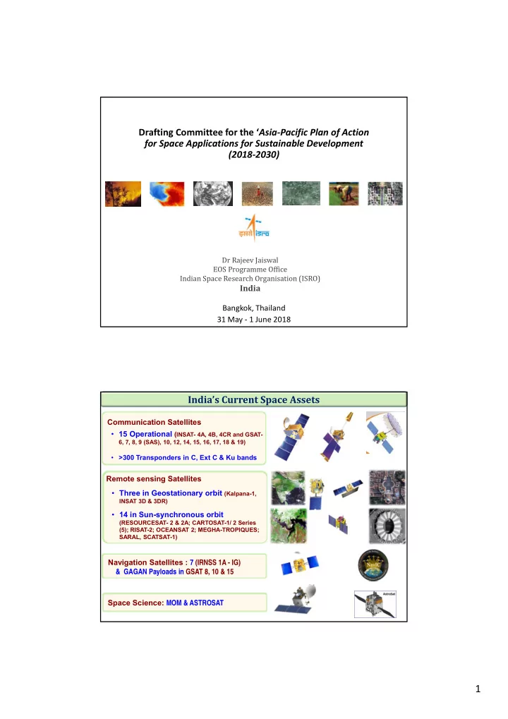
SLIDE 3 3
SDGs & Indian Space Programme
Tele-medicine, Air Quality Forecast / Monitoring, NICES (53 Products including 13 ECVs) Solar, Wind, Wave & HEP Potential Estimation Infrastructure Planning, Disaster Management Support Tele-education, e-learning, Academic collaboration, Technology transfer to industries Joint Missions with Int. Space Agencies, South Asia Satellite, Data Support for International Charter, Bilateral/Multi-lateral Cooperation, COSPAS-SARSAT, CSSTE-AP Natural Resources Census, PFZ Forecast, Areas for Crops’ Expansion, Desertification and Land Degradation
Collaboration Internalization Institutionalization IMD Weather Services MNCFC Crop Services INCOIS Ocean Services FSI
Mapping, Fire Alerts
NDEM
DM Services
Information Dissemination
Bhuvan
Weather Service INSAT 3D/ 3DR 96 images/ day Cartography Cartosat-2 Series 0.65m PAN, 2m MX GAGAN NavIC NR Mapping 3Tier Imaging) 6m/23m/56m MX
0.25m P + 1m MX 1.25m P (STEREO) + 2.5m MX 50 m MX (Daily) L & S-Band SAR
In Plan
Natural Resources Conservation Health/Climate Change Induced Impact Disaster Resilient Community Renewable Energy Capacity Building International Cooperation
Solar Energy LULC TM Network
Country practices in Action Area‐1 (Research and Knowledge sharing) Indian Trends in Support of SDGs
Product Availability AWiFS Ortho 56 m 2008, 2009, 2010, 2013 LISS-3 Ortho 23 m 2008-09, 2011, 2012, 2013 IMS-1/HYSI 2008-2012 Oceansat OCM GAC 2011-2015
Free downloads through Bhuvan
- Free downloads coarser than 23m resolution,
CartoDEM, Oceansat data, Scatsat‐1 data etc. made available free and open since 2010.
- Total 10.08 lakhs products in 2017‐18 itself.
More numbers
satellites and enhanced capability
- Three tier imaging : 56 m / 23 m / 5.8 m
- Revisit Capability : 03 / 11 / 03 days
- 2.5 m Stereo imaging
- Sub-meter PAN and 1.5 m Multi-spectral
- Ocean color 360 m with 2 days revisit
- PFZ, Ocean State Forecast
- Ocean Altimetry, Surface Wind Vector
- 6 Bands Imager – 48 images per day
- 19 Channel Sounder – Atm. Profiles
- Radio Occultation – humidity profiles
Easy access to data
- Satellite data prices are reducing
- Most of the data becoming ‘Open and Free’
- More data portals like Bhuvan, Mosdac, etc.
Space agencies are operating or planning 322 individual EO satellite in the 2017 – 2032 period ‐ CEOS report
Enhanced data processing infrastructure
- Analysis Ready Data and time series data
- Better storage to archive old data, parameter
retrieval, ECV inventory