SLIDE 1
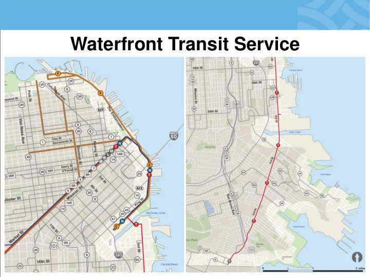
Waterfront Transit Service
SLIDE 2 Transit Service Challenges
- Safety
- Rail Reliability and
Flexibility
– E Line operational constraints – 4th & King bottleneck – MME pull-in and pull-out constraints
- Traffic Congestion
- Storage and Terminal
Facilities
- Intensity of Special Events
- Keeping up with Growing
Service Needs
SLIDE 3 Muni Forward Implementation
Changes
Projects
Safety Improvements
RECENT INVESTMENTS
SLIDE 4 Street Car & Light Rail Service Increases
– E-Line: New service from 4th and King (Caltrain) to Fisherman's Wharf
improvements
service
frequency
RECENT INVESTMENTS
SLIDE 5 Expanded and Increased Bus Service
- New route (55-16th Street) from 16th Street BART to Mission Bay
- New late night Owl service connections to southern waterfront
- Frequency increases and changes to improve reliability on routes
serving waterfront
RECENT INVESTMENTS
SLIDE 6 Signal Improvements
- New and improved signal timing
along King Street and Embarcadero
– Increases reliability and travel time
WORK UNDERWAY
SLIDE 7 Surface Light Rail Projects
Track
– Crossover: Between Harrison and Bryan – Pocket Track: Between Brannan and Townsend
Enhancements
- ATCS upgrades
- Crossovers into
Warrior’s Platform
WORK UNDERWAY
SLIDE 8 Central Subway
- Direct link and more frequent service from southern waterfront
and Mission Bay to SOMA, Downtown and Chinatown
- More fixed-rail flexibility in targeting service demands
WORK UNDERWAY
SLIDE 9 Historic Street Car Strategic Plan
- Improve service reliability and accessibility
- Preserve fleet availability
- Resolve E & F line shared terminals
UNFUNDED PROJECTS FOR FUTURE NEEDS
SLIDE 10 New Service to Meet Future Growth
- New routes concepts to connect
northern and central waterfront through SOMA and Downtown
– Pier 70 and Candlestick/Hunter’s Point
- Owl service to Fisherman’s Wharf
UNFUNDED PROJECTS FOR FUTURE NEEDS
SLIDE 11 Policy Recommendations
- Adopt SF Planning Department’s
Transit-Supportive Development Design Guidelines
- Support Transit Through Land
Use Policy
– Locate high density and activity centers within shortest walk to transit stops
- Promote Public Transit As
Primary Mode
– Design streets and transit facilities that support reliability, resiliency, and flexibility
- Encourage Transit Use Through
Travel Demand Management
SLIDE 12
Embarcadero Pedestrian and Bicycle Improvements
SLIDE 13 Pedestrian and Bicycle Planning Policy and Improvement Coordination
Taking a ‘Complete Streets’ approach towards transportation
- Embarcadero – Short and Long Term Enhancements
- Blue Greenway/Terry Francois Boulevard
- Challenges
SLIDE 14
How Popular and Multi-Modal is the Waterfront?
Very!
SLIDE 15 How Popular and Multi-Modal is the Waterfront?
Bicycle and Pedestrian Volumes – 2015
Weekday 2-hour PM peak
SLIDE 16
How Popular and Multi-Modal is the Waterfront?
SLIDE 17
Introduction
Conflict
SLIDE 18
Conflict
SLIDE 19
Introduction
Uncomfortable
SLIDE 20 20
Safety
Between 2011 and 2016, 192 people were killed or injured on The Embarcadero, including:
- 1 Pedestrian fatality
- 1 Motorist fatality
- 6 Pedestrians severely injured
- 10 Bicyclists severely injured
- 3 Motorists severely injured
SLIDE 21 Embarcadero – Short Term Improvements
– New signage and stenciling on Promenade – Bike Lane Improvements – Pedestrian Safety Treatments
SLIDE 22 What is the Project?
- Planning
- Safety and Comfort
- Design Concept
- ‘Complete Street’
Embarcadero Enhancement Project
SLIDE 23
Alignment Options
SLIDE 24
Terry Francois Boulevard Project
SLIDE 25 Supportive Projects
- Better Market Street
- Ferry Terminal Expansion Project
- Seawall Resiliency Project
- Transbay Center District Plan
- Blue Greenway/3rd Street Bridge
Retrofit
- Jefferson Street Public Realm
- E-Line Streetcar Service Expansion
- Bay Bridge West Span Pathway Study
- Waterfront Transportation Assessment
SLIDE 26 Challenges
- Funding
- Competing interests/demands
- Modal hierarchy does not necessarily apply
- Changing demands for curbside uses
- Lack of unifying transportation policy
- Congestion is variable
- Width of The Embarcadero
- One-Size Fits All Approach will not work
SLIDE 27 Curb Space: An Asset Hidden in Plain Sight
NACTO Designing Cities Conference Kevin O’Neill, Meghan Shepard September 28, 2016
SLIDE 28 Our mission, vision, and core values
Committed to 5 core values to create a city that is:
- Safe
- Interconnected
- Affordable
- Vibrant
- Innovative
For all
Mission: deliver a high-quality transportation system for Seattle Vision: connected people, places, and products
28
SLIDE 29
by geography (water, hills)
for multiple purposes (transit, freight, general purpose, access, etc.)
Seattle’s street system
SLIDE 30
focuses growth:
Urban centers Manufacturing & industrial centers Urban villages
centers/villages since 1994
2015-2035
households
Seattle’s growth strategy
SLIDE 31 Comprehensive Plan Transportation Element: key themes
Use right-of-way for multiple purposes
31
Invest in travel
Ensure goods movement
SLIDE 32
all functions of the public right-of-way, including access and activation (not just mobility)
identifies new framework ROW allocation decisions
Right-of-way (ROW) allocation
SLIDE 33 ROW allocation: zones
33
SLIDE 34 ROW allocation: functions
34
SLIDE 35
Outcome: multi-functional streets
SLIDE 36 Making the best use
36
SLIDE 37 What is the flex zone?
37
SLIDE 38 New curb demands
38
SLIDE 39 Five year changes to curb*
- Transit projects
- Bicycle projects
- Streetscape projects
- Private development
* Assumes build-out of projects in Transit, Pedestrian, Freight and Bicycle Modal Plans
SLIDE 40 Curbspace in Seattle’s CBD
40
SLIDE 41 CBD curb use and function today
41
SLIDE 42 5-year function changes
42
SLIDE 43 43
Changes in loading
SLIDE 44 Seattle curbspace priorities
44
SLIDE 45 Urban goods delivery strategy
“Provide a freight network that supports a thriving and diverse economy for Seattle and the region.”
Master Plan, September 2016
SLIDE 46
distance for loading
any business address either in on-street, alley or off-street locations
Loading minimums
SLIDE 47 Design strategies
access through creative design
alley vacations on nearby properties
3rd Avenue flex/load zone
47
SLIDE 48 Commercial load zone strategies
delivery pilot
commercial load zone permit pricing structure to better manage demand
48
SLIDE 49 Off-street strategies
in off-street loading dock and use standards
development requirements for package storage
SLIDE 50 Freight demand management strategies
- Consolidate trips
- Enable right-size
vehicles in dense areas
technology to guide deliveries and manage access
50
SLIDE 51
Questions?
kevin.oneill2@seattle.gov | (206) 386-4556
meghan.shepard@seattle.gov | (206) 684-4208
www.seattle.gov/transportation