
SLIDE 1
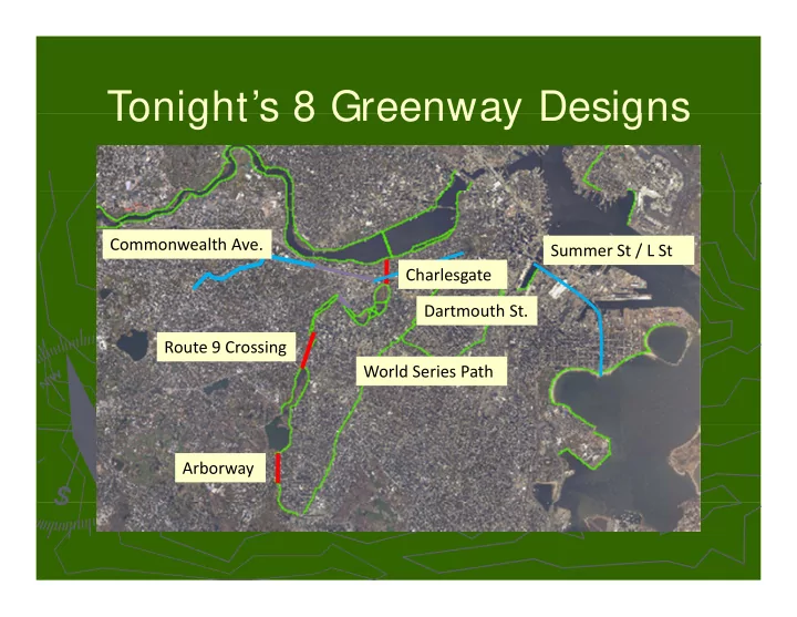
Tonight’s 8 Greenway Designs Tonight s 8 Greenway Designs
Ch l Commonwealth Ave. Summer St / L St Route 9 Crossing Charlesgate Dartmouth St. Route 9 Crossing World Series Path Arborway
Tonights 8 Greenway Designs Tonight s 8 Greenway Designs - - PowerPoint PPT Presentation
Tonights 8 Greenway Designs Tonight s 8 Greenway Designs Commonwealth Ave. Summer St / L St Ch Charlesgate l Dartmouth St. Route 9 Crossing Route 9 Crossing World Series Path Arborway 2008 Charlesgate Connection Northeastern
Ch l Commonwealth Ave. Summer St / L St Route 9 Crossing Charlesgate Dartmouth St. Route 9 Crossing World Series Path Arborway
h ’ l h ’ l Northeastern University’s Civil Engineering Transportation Design Capstone Northeastern University’s Civil Engineering Transportation Design Capstone
Bicycling Around the Back Bay “The BaBBs” M V l ki Matt Volovski Kelly Chronley Josh Barnett Tony Coward
► Harvard University with
Harvard University with Harvard Medical Harvard Medical
► Connects the beautiful
Connects the beautiful Charles River and Fens Parks Charles River and Fens Parks
► Boston University with Boston
Boston University with Boston University Medical University Medical
► MIT University with Longwood
MIT University with Longwood
► Provides access to Olmsted’s
Provides access to Olmsted’s Park Park
► Discovers the Lost Park
Discovers the Lost Park Medical Area and Jamaica Plain Medical Area and Jamaica Plain
► Massachusetts General Hospital
Massachusetts General Hospital with Longwood Medical Area with Longwood Medical Area and Jamaica Plain and Jamaica Plain and Jamaica Plain and Jamaica Plain
► Downtown to Fenway/Jamaica
Downtown to Fenway/Jamaica Plain Plain
► Emerald Necklace Master Plan (1989)
► Emerald Necklace Master Plan (1989)
► Muddy River Delta Proposal (1996)
► Charlesgate Interchange Park Charrette (1998)
► Charlesgate Interchange Park Charrette (1998)
► The Emerald Necklace Greenway Plan (2001)
► The MDC Charlesgate Connection Plan (2002)
► The MDC Charlesgate Connection Plan (2002)
► The Boston Bicycle Summit (2007)
► Accommodates:
Pedestrian Pedestrian Pedestrian
Cyclists
Handicapped ► 12 foot width
► Buffered from traffic
To get between the Bowker/Boylston intersection and Commonwealth Ave. To get between the Bowker/Boylston intersection and Commonwealth Ave.
Currently the sidewalks on the Bowker Overpass are inadequate, only 6’
Currently the sidewalks on the Bowker Overpass are inadequate, only 6’ wide and un wide and un-
buffered from traffic.
The Massachusetts Turnpike
The Massachusetts Turnpike h l d k h l d k
The railroad tracks
The railroad tracks
The Bowker Overpass
The Bowker Overpass
Additional width on the overpass
Additional width on the overpass
The structure can not support a cantilevered pedestrian bridge
The structure can not support a cantilevered pedestrian bridge
A free
A free-
standing pedestrian bridge over the Mass. Pike and railway would be Long (> 200’) and costly be Long (> 200’) and costly
► Currently there are 3 southbound
Currently there are 3 southbound l d 3 hb d l l d 3 hb d l lanes and 3 northbound lanes lanes and 3 northbound lanes
► 3 southbound lanes are critical to
3 southbound lanes are critical to the functionality of the intersection the functionality of the intersection 3 thb d l l th 3 thb d l l th
► 3 northbound lanes only serve the
3 northbound lanes only serve the function of 2 lanes: function of 2 lanes:
Only 2 lanes of traffic ever enter the northbound lanes northbound lanes
Creates additional movements and conflicts for drivers conflicts for drivers
► Elimination of 1 NB lane would
Elimination of 1 NB lane would i d i i f t hil i d i i f t hil increase driving safety while increase driving safety while providing space for a pathway. providing space for a pathway.
► Single narrow sidewalk
Single narrow sidewalk
► Not ADA compliant
Not ADA compliant
Would be very difficult to gain compliance
► 2 lanes
2 lanes
Both are necessary for queue storage
► Ramp structure can not support cantilever
Ramp structure can not support cantilever
► Single narrow sidewalk
Single narrow sidewalk
► Single narrow sidewalk
Single narrow sidewalk
► Not ADA compliant
Not ADA compliant
Currently there is a ramp that can be upgraded for that can be upgraded for pg pg compliancy compliancy
► 2 lanes
2 lanes
Both are not necessary
Two lanes merge down to
► Ramp structure can be
Ramp structure can be
► Ramp structure can be
Ramp structure can be altered altered
Proposed Conditions
This is a rendering of what the southbound lanes of the Bowker Overpass will look like.
Existing Conditions
This is an image taken from the Bowker/Boylston Intersection looking at the southbound lanes of the Intersection looking at the southbound lanes of the Bowker Overpass.
► (A)
Requires crossing Charlesgate West traffic Charlesgate West traffic twice twice twice twice ► (B)
Not enough width Not enough width ► (C)
Not enough clearance ► (D1 2 3)
fi l Th fi l ► (D1, 2, 3)
The final three alternatives were three alternatives were paths that crossed over the paths that crossed over the
ramp at different l ti l ti locations. locations.
► The Onramp Crossing
► The Onramp Crossing
Signaled crossing g g g g
125’ from intersection providing room for 10 cars providing room for 10 cars in a queue in a queue in a queue in a queue
Separate ADA ramp to Charlesgate West and Charlesgate West and g Newbury St. Newbury St.
► Connects Overpass to the corner of Charlesgate West and Newbury
Connects Overpass to the corner of Charlesgate West and Newbury Street. Street.
► Ideal Crossing Location Because:
Ideal Crossing Location Because:
Clear sightline down Charlesgate West
Short crossing distance (25’)
Motorists will be slowing to round the corner Motorists will be slowing to round the corner Motorists will be slowing to round the corner
ADA Features: ADA Features:
1/12 slope
Landings every g y g y 30 linear feet 30 linear feet
Objective: Objective:
► Improving
Improving pedestrian service pedestrian service through through intersection intersection
► While maintaining
While maintaining
vehicular service vehicular service
Pedestrians delay shortens from 69 sec to 38 sec and from 41 sec to 38 sec Vehicular delay maintained or improved Vehicular delay maintained or improved
► Currently oversized
Currently oversized lanes lanes
lanes lanes
► Reduce lane width
Reduce lane width to standard 12’ to standard 12’ E d th b E d th b
► Expand south curb
Expand south curb line line
Creates a constant
Creates a constant sightline down sightline down sightline down sightline down Beacon Beacon
Allows island to be
Allows island to be enlarged enlarged
Creates a
Creates a constant sightline constant sightline down Beacon down Beacon
Allows island to
Allows island to be enlarged be enlarged be enlarged be enlarged
► Go to Right of Pier:
► Go to Right of Pier:
Left side of pier does not have required width
Left side of pier in not buffered from traffic p
► Alternative
► Right Side of Pier
► Right Side of Pier
Current overhead clearance for clearance for right side of pier right side of pier
► Alternative B:
► Right Side of Pier
► Right Side of Pier
Overhead Clearance for Clearance for Right Side of Pier Right Side of Pier After Re After Re-
grading
► Excavation
► Excavation
Drainage solution solution
Vi f th l l f th k Vi l th Ch l Ri d t
Reclaiming 2 5 acres of parkland
View from the upper level of the park View along the Charles River downstream
Reclaiming 2.5 acres of parkland near the Charles River near the Charles River
Creating a destination rather C eat g a dest at o at e C eat g a dest at o at e than just a connection than just a connection
All bridges were designed meeting the following requirement: A clearance of 12’ from Storrow Drive to the bottom of the bridge deck A 1’ thick bridge deck A single span crossing Storrow Drive supported on both sides with
piers
An overall width of 12’ The ramp is compliant with ADA requirements 1/12 slope Landings provided every 2.5’ of elevation change
Alternative A:
Bridge crossing to Bridge crossing to the west and the resulting 193’ ramp down towards the east
Alternative B
Bridge crossing to the east and the resulting 150’ ramp down towards the west west
Alternative C Alternative C
The design calls for a piers to be placed in the Charles River. The major benefit is the relatively low visual impact. visual impact.
Alternative D
Th d d i The grand design. It calls for a cable- stayed ramp extending over the g river.
(cont )
(cont.)
Typical Elevation 3-D Rendering
Upstream Downstream Extra Travel Distance (Compaired to best Alternative) Alternative Horizontal Impact Distance
A 193' 0' 464' 407' B 150' 0' 342' 0' C 52' 62' 65' 240' D 114' 32' 0' 291'
Acknowledgements: Acknowledgements: Acknowledgements: Acknowledgements:
This report could not have been possible without the support of our Professor Peter Furth and the This report could not have been possible without the support of our Professor Peter Furth and the coordination of our design team. We would like to first thank VHB and the Boston Water and Sewer coordination of our design team. We would like to first thank VHB and the Boston Water and Sewer Commission for providing the CAD files for the existing conditions of the Charlesgate connection. We Commission for providing the CAD files for the existing conditions of the Charlesgate connection. We also would like to recognize Herb Nolan of the Solomon Fund for showing interest to advance this also would like to recognize Herb Nolan of the Solomon Fund for showing interest to advance this also would like to recognize Herb Nolan of the Solomon Fund for showing interest to advance this also would like to recognize Herb Nolan of the Solomon Fund for showing interest to advance this project further once we graduate. A few others we would like to thank: Nicole Freedman, Boston’s project further once we graduate. A few others we would like to thank: Nicole Freedman, Boston’s Bicycle Planner, Noah Bierman, Boston Globe, John Kennedy, VHB, John Ciccarelli, Bicycle Solutions, Bicycle Planner, Noah Bierman, Boston Globe, John Kennedy, VHB, John Ciccarelli, Bicycle Solutions, and Northeastern University for providing the survey equipment, as well as the software to finish this and Northeastern University for providing the survey equipment, as well as the software to finish this project. project.