SLIDE 1 REGIONAL MORRIS CANAL GREENWAY
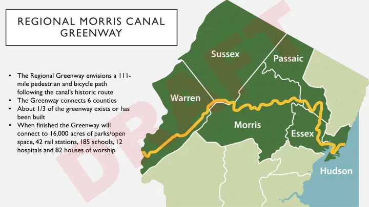
- The Regional Greenway envisions a 111-
mile pedestrian and bicycle path following the canal’s historic route
- The Greenway connects 6 counties
- About 1/3 of the greenway exists or has
been built
- When finished the Greenway will
connect to 16,000 acres of parks/open space, 42 rail stations, 185 schools, 12 hospitals and 82 houses of worship
D R A F T
SLIDE 2 GREENWAY OBJECTIVES
Morris Canal in Jersey City Greenway Rendering : Canal Crossing
- Renew connection between the community
and its history
- Provide safe and convenient access for
residents and visitors to neighborhoods, parks, schools, businesses, attractions, and transit
- Create a world-class bicycle and pedestrian
destination
D R A F T
SLIDE 3 MORRIS CANAL GREENWAY IN JERSEY CITY
- The Jersey City portion stretches 8.5 miles
- The plan calls for a combination of on-road
and off-road segments
- 50% of the Greenway is either complete or
in-progress
- Jersey City was awarded a $3.5 million
grant from the NJ Dept. of Transportation for the first phase of construction.
- Jersey City Redevelopment Agency was
awarded a $800,000 grant from the EPA to address environmental concerns.
- The Greenway will connect 20 schools, 26
parks, 24 houses of worship, 6 neighborhoods and 3 health centers
D R A F T
SLIDE 4 GREENWAY SECTIONS
Berry Lane Park: Greenway Entrance Hudson River Walkway: Paulus Hook
- 2 sections of the Greenway are complete
- Section 9: Berry Lane Park (0.4 Miles)
- Section 14: Hudson River Walkway (1.1 Miles)
- 5 Sections are In-Progress
- Section 3: Country
Village (1 Mile)
- Section 4: Mercer Park (0.2 Miles)
- Section 5: Southern End (1.3 Miles)
- Section 10: Whitlock Cordage (0.4 Miles)
- Section 11: Carbon St (0.3 Miles)
D R A F T
SLIDE 5 PROJECT FUNDING
Project is funded by 2 grants received by the City and the Jersey City Redevelopment Agency:
- Transportation Alternatives Grant
(TAP) from the NJDOT and NJTPA
- Environmental Remediation Grant
from the EPA
D R A F T
SLIDE 6 SEGMENT 3 – COUNTRY VILLAGE SECTION
McGovern Park: Greenway Entrance Trail location along Sullivan Drive
4,000 foot long section consisting of an off- street trail from the Society Hill jughandle at Route 440 to McGovern Park and then an on- street segment on Custer Avenue from McGovern Park to JFK Boulevard.
D R A F T
SLIDE 7
TRAIL ALIGNMENT
D R A F T
SLIDE 8
LOOKING NORTH FROM MINA DRIVE
D R A F T
SLIDE 9
TRAIL ALIGNMENT
D R A F T
SLIDE 10
CUSTER AVE- LOOKING EAST TO JFK BLVD
D R A F T
SLIDE 11 TRAIL FEATURES
- 10 foot wide paved trail.
- Landscaping including trees, shrubs and new
lawn area.
- Amenities including benches and trash
receptacles.
- Lighting and security cameras.
- Stormwater facilities.
- Wayfinding signage and historical markers.
- Environmental cleanup of existing historic fill
consisting of a engineered cap.
- WILL ADD A CROSS SECTION OF TRAIL
HERE.
Existing Stairs at McGovern Park Trail Rendering
D R A F T
SLIDE 12
SECTION 4: MERCER PARK
D R A F T
SLIDE 13 MORRIS CANAL GREENWAY
D R A F T
SLIDE 14
SEGMENT 5 MERCER PARK TO CAVEN POINT ROAD
Mercer Park | Merritt Street | Garfield Avenue | Gates Avenue | Princeton Avenue | Linden Avenue
D R A F T
SLIDE 15
MERRITT STREET @ AVENUE C
D R A F T
SLIDE 16
MERRITT STREET
SEGMENT 5: EXISTING CONDITIONS Merritt Street @ Avenue C
D R A F T
SLIDE 17 SEGMENT 5: OPTION 1 MERRIT STREET @ AVENUE C
- 1.14 miles of protected bike lanes
- 8,438 sq. ft. of pedestrian
enhancements (curb extensions, landscaping with green infrastructure, new lighting, additional crosswalks
- 1.14 miles of protected bike lanes
- 8,258 sq. ft. of pedestrian enhancements (curb
extensions, landscaping with green infrastructure, new lighting, additional crosswalks)
SEGMENT 5: OPTION 1 Merritt Street @ Avenue C
D R A F T
SLIDE 18
- .43 miles of protected bike lanes
- .71 miles of shared use lane markings
- 15,568 sq. ft. of pedestrian enhancements
(curb extensions, landscaping with green infrastructure new lighting additional crosswalks)
SEGMENT 5: OPTION 2 Merritt Street @ Avenue C
D R A F T
SLIDE 19
PRINCETON STREET BETWEEN BROWN PL./ WINFIELD AVE.
D R A F T
SLIDE 20
SEGMENT 5: EXISTING CONDITIONS Princeton Street Between Brown Pl. / Winfield Ave.
D R A F T
SLIDE 21
SEGMENT 5: OPTION 1 Princeton Street Between Brown Pl. / Winfield Ave.
D R A F T
SLIDE 22
SEGMENT 5: OPTION 2 Princeton Street Between Brown Pl. / Winfield Ave.
D R A F T
SLIDE 23
SEGMENT 10, 11 COMMUNIPAW AVENUE TO PACIFIC AVENUE
Whitlock Cordage | Maple Street | Van Horne Street | Carbon Street | Pacific Avenue
D R A F T
SLIDE 24
CARBON STREET BETWEEN VAN HORNE ST. + HALLADAY ST.
D R A F T
SLIDE 25
SEGMENT 11: EXISTING CONDITIONS
D R A F T
SLIDE 26
- 0.67 miles of protected bike lanes
- 12,361 sq. ft. of pedestrian enhancements
(curb extensions, landscaping with green infrastructure, new lighting, additional crosswalks)
SEGMENT 11: OPTION 1
D R A F T
SLIDE 27 SEGMENT 11: OPTION 2
- 0.42 miles of shared use lane markings
- .25 miles of protected bike lane
- 12,548 sq. ft. of pedestrian enhancements (curb
extensions, landscaping with green infrastructure, new lighting, additional crosswalks)
D R A F T
SLIDE 28
PROJECT TIMELINE
Survey completed – Winter 2020 Design & Permitting - Ongoing Complete design – Fall 2020 Bid project & award construction contract – winter 2020/2021 Start of construction – Spring 2021
D R A F T
SLIDE 29
SEGMENT 5: PARKING IMPACTS OPTION 1 VS. OPTION 2
Existing: 264 Spaces Option 1: 121spaces (54% reduction) Option 2: 208 space (22% reduction)
D R A F T
SLIDE 30
SEGMENT10,11: PARKING IMPACTS Option 1 vs. Option 2
Existing: 72 Spaces Option 1: 34 spaces (52% reduction) Option 2: 56 spaces (23% reduction)
D R A F T